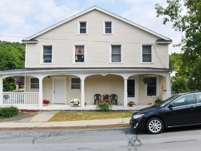
Property Record
4 Main St, Otisville, NY 10963
NEARBY LISTINGS FOR SALE OR LEASE
-
-
View all Otisville listings for sale on LoopNet.com
Property Detail
4 Main St
New York-Jersey City-White Plains, NY-NJ
Orange
334401-104-000-0002-055.000-0000
New York
Townhouserowhouse
0.19 AC
X
Middletown
36071C0231E
Northern New Jersey
4,536 SF
DEMOGRAPHICS near 4 Main St
1 Mile
3 Mile
5 Mile
2024 Total Population
1,458
6,172
13,133
2029 Population
1,484
6,268
13,341
Pop Growth 2024-2029
+ 1.78%
+ 1.56%
+ 1.58%
Average Age
41
42
42
2024 Total Households
518
1,780
4,224
HH Growth 2024-2029
+ 1.93%
+ 1.63%
+ 1.66%
Median Household Inc
$87,500
$105,804
$105,432
Avg Household Size
2.60
2.80
2.80
2024 Avg HH Vehicles
2.00
2.00
2.00
Median Home Value
$276,219
$281,901
$285,612
Median Year Built
1958
1974
1975
Nearby Places
Map Layers
Map Styles
 Street
 Aerial
- Restaurants
- Banks
- Shops
- Fitness
- Groceries
PUBLIC TRANSPORTATION
COMMUTER RAIL
Otisville (Bergen County/Port Jervis Line - NJ Transit Commuter Rail (NJ Transit), Main/Port Jervis Line - NJ Transit Commuter Rail (NJ Transit))
DRIVE
WALK
Distance
Otisville (Bergen County/Port Jervis Line - NJ Transit Commuter Rail (NJ Transit), Main/Port Jervis Line - NJ Transit Commuter Rail (NJ Transit))
1 min
12 min
0.6 mi
AIRPORT
New York Stewart International
DRIVE
WALK
Distance
New York Stewart International
44 min
31.2 mi
Freight Ports
Port Newark Container Terminal
DRIVE
WALK
Distance
Port Newark Container Terminal
107 min
79.8 mi
SALE & LEASE HISTORY
LISTING DATE
SALE/LEASE

Sep 24, 2016
For Sale
Nearby Properties
Address
Land Use
TOTAL SIZE
Lot Size
Zoning
Address
Land Use
TOTAL SIZE
Lot Size
Zoning
234.30 AC
Address
Land Use
TOTAL SIZE
Lot Size
Zoning
648.10 AC
Address
Land Use
TOTAL SIZE
Lot Size
Zoning
363.60 AC
Address
Land Use
TOTAL SIZE
Lot Size
Zoning
Address
Land Use
TOTAL SIZE
Lot Size
Zoning
153.80 AC
Address
Land Use
TOTAL SIZE
Lot Size
Zoning
46.70 AC
Address
Land Use
TOTAL SIZE
Lot Size
Zoning
26.40 AC
Address
Land Use
TOTAL SIZE
Lot Size
Zoning
9,100 SF
2.50 AC
RA
Address
Land Use
TOTAL SIZE
Lot Size
Zoning
9,200 SF
1.80 AC
Address
Land Use
TOTAL SIZE
Lot Size
Zoning
Address
Land Use
TOTAL SIZE
Lot Size
Zoning
Address
Land Use
TOTAL SIZE
Lot Size
Zoning
2,400 SF
61.60 AC
Address
Land Use
TOTAL SIZE
Lot Size
Zoning
2,137 SF
162.60 AC
Address
Land Use
TOTAL SIZE
Lot Size
Zoning
1.50 AC
RA
Address
Land Use
TOTAL SIZE
Lot Size
Zoning
35.30 AC
Address
Land Use
TOTAL SIZE
Lot Size
Zoning
1,224 SF
73 AC
RA
Address
Land Use
TOTAL SIZE
Lot Size
Zoning
12,105 SF
12.30 AC
Address
Land Use
TOTAL SIZE
Lot Size
Zoning
Address
Land Use
TOTAL SIZE
Lot Size
Zoning
17,068 SF
1.90 AC
Address
Land Use
TOTAL SIZE
Lot Size
Zoning
0.17 AC
Address
Land Use
TOTAL SIZE
Lot Size
Zoning
196 AC
Address
Land Use
TOTAL SIZE
Lot Size
Zoning
35.60 AC
Address
Land Use
TOTAL SIZE
Lot Size
Zoning
10,912 SF
1 AC
05
Address
Land Use
TOTAL SIZE
Lot Size
Zoning
Address
Land Use
TOTAL SIZE
Lot Size
Zoning
2,862 SF
41.70 AC
Address
Land Use
TOTAL SIZE
Lot Size
Zoning
12,980 SF
29.60 AC
Address
Land Use
TOTAL SIZE
Lot Size
Zoning
6,766 SF
2.90 AC
RA
Address
Land Use
TOTAL SIZE
Lot Size
Zoning
58,131 SF
52 AC
Address
Land Use
TOTAL SIZE
Lot Size
Zoning
25.20 AC
Address
Land Use
TOTAL SIZE
Lot Size
Zoning
10,264 SF
121.20 AC
RA
The World's #1 Commercial Real Estate Marketplace
Connect with us
© 2025 CoStar Group
The information above has been obtained from sources believed reliable. While we do not doubt its accuracy we have not verified it and make no guarantee, warranty or representation about it. It is your responsibility to independently confirm its accuracy and completeness. Any projections, opinions, assumptions, or estimates used are for example only and do not represent the current or future performance of the property. The value of this transaction to you depends on tax and other factors which should be evaluated by your tax, financial, and legal advisors. You and your advisors should conduct a careful, independent investigation of the property to determine to your satisfaction the suitability of the property for your needs.