Property Record
4 Merrit Pkwy, Nashua, NH 03062
NEARBY LISTINGS FOR SALE OR LEASE
Property Detail
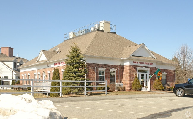
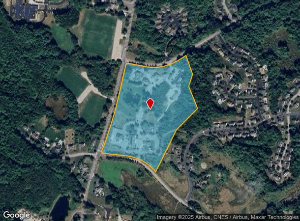
4 Merrit Pkwy
NASH-000000-002544-000004C
Commerce Center At Ma
Commercialbuilding
Hillsborough
X
New Hampshire
25017C0084F
2544
2024
Hillsborough
2024
Boston
011402
Manchester-Nashua, NH
8,000 SF
DEMOGRAPHICS near 4 Merrit Pkwy
1 Mile
3 Mile
5 Mile
2024 Total Population
4,909
45,732
106,873
2029 Population
5,027
46,561
108,565
Pop Growth 2024-2029
+ 2.40%
+ 1.81%
+ 1.58%
Average Age
42
43
41
2024 Total Households
1,715
18,552
43,690
HH Growth 2024-2029
+ 2.45%
+ 1.83%
+ 1.62%
Median Household Inc
$120,992
$101,613
$92,594
Avg Household Size
2.80
2.40
2.40
2024 Avg HH Vehicles
2.00
2.00
2.00
Median Home Value
$423,377
$369,743
$373,369
Median Year Built
1983
1980
1974
Nearby Places
Map Layers
Map Styles
 Street
 Aerial
- Restaurants
- Banks
- Shops
- Fitness
- Groceries
PUBLIC TRANSPORTATION
AIRPORT
Manchester Boston Regional
DRIVE
WALK
Distance
Manchester Boston Regional
28 min
17.7 mi
General Edward Lawrence Logan International
DRIVE
WALK
Distance
General Edward Lawrence Logan International
63 min
41.2 mi
Freight Ports
Port of Boston
DRIVE
WALK
Distance
Port of Boston
64 min
41.0 mi
Nearby Properties
Address
Land Use
TOTAL SIZE
Lot Size
Zoning
Address
Land Use
TOTAL SIZE
Lot Size
Zoning
19.70 AC
RB
Address
Land Use
TOTAL SIZE
Lot Size
Zoning
28.04 AC
PI
Address
Land Use
TOTAL SIZE
Lot Size
Zoning
38.17 AC
RC
Address
Land Use
TOTAL SIZE
Lot Size
Zoning
29.77 AC
RC
Address
Land Use
TOTAL SIZE
Lot Size
Zoning
20.72 AC
RC
Address
Land Use
TOTAL SIZE
Lot Size
Zoning
15.19 AC
RC
Address
Land Use
TOTAL SIZE
Lot Size
Zoning
60.25 AC
PI
Address
Land Use
TOTAL SIZE
Lot Size
Zoning
118.50 AC
PI
Address
Land Use
TOTAL SIZE
Lot Size
Zoning
20.80 AC
RC
Address
Land Use
TOTAL SIZE
Lot Size
Zoning
52.45 AC
R18
Address
Land Use
TOTAL SIZE
Lot Size
Zoning
21.40 AC
RC
Address
Land Use
TOTAL SIZE
Lot Size
Zoning
74.50 AC
R9
Address
Land Use
TOTAL SIZE
Lot Size
Zoning
12.55 AC
RC
Address
Land Use
TOTAL SIZE
Lot Size
Zoning
33.81 AC
PI
Address
Land Use
TOTAL SIZE
Lot Size
Zoning
21.17 AC
RC
Address
Land Use
TOTAL SIZE
Lot Size
Zoning
77,276 SF
19.50 AC
PI
Address
Land Use
TOTAL SIZE
Lot Size
Zoning
12.57 AC
RC
Address
Land Use
TOTAL SIZE
Lot Size
Zoning
144,018 SF
13.89 AC
PI
Address
Land Use
TOTAL SIZE
Lot Size
Zoning
233,668 SF
16.83 AC
PI
Address
Land Use
TOTAL SIZE
Lot Size
Zoning
161,790 SF
9 AC
PI
Address
Land Use
TOTAL SIZE
Lot Size
Zoning
129,441 SF
18.90 AC
R9
Address
Land Use
TOTAL SIZE
Lot Size
Zoning
42.06 AC
IND
Address
Land Use
TOTAL SIZE
Lot Size
Zoning
124,205 SF
19.38 AC
R9
Address
Land Use
TOTAL SIZE
Lot Size
Zoning
108,514 SF
5.79 AC
HB
Address
Land Use
TOTAL SIZE
Lot Size
Zoning
80,021 SF
4.55 AC
PI
Address
Land Use
TOTAL SIZE
Lot Size
Zoning
95,040 SF
7.33 AC
RC
Address
Land Use
TOTAL SIZE
Lot Size
Zoning
185,110 SF
11.25 AC
PI
Address
Land Use
TOTAL SIZE
Lot Size
Zoning
123,414 SF
13.98 AC
GB
Address
Land Use
TOTAL SIZE
Lot Size
Zoning
108,300 SF
7.77 AC
GB
The World's #1 Commercial Real Estate Marketplace
Connect with us
© 2025 CoStar Group
The information above has been obtained from sources believed reliable. While we do not doubt its accuracy we have not verified it and make no guarantee, warranty or representation about it. It is your responsibility to independently confirm its accuracy and completeness. Any projections, opinions, assumptions, or estimates used are for example only and do not represent the current or future performance of the property. The value of this transaction to you depends on tax and other factors which should be evaluated by your tax, financial, and legal advisors. You and your advisors should conduct a careful, independent investigation of the property to determine to your satisfaction the suitability of the property for your needs.