Property Record
4 Miltmore Rd, Antrim, NH 03440
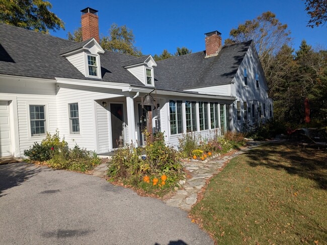
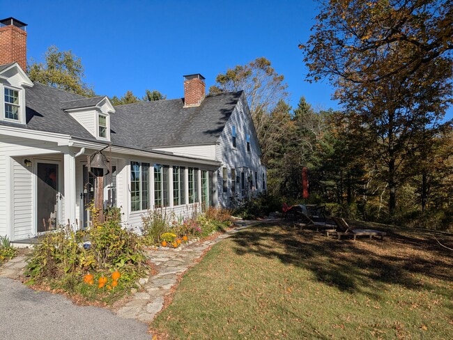
This Property Is For Sale
NEARBY LISTINGS FOR SALE OR LEASE
-
-
View all Antrim listings for sale on LoopNet.com
Property Detail
4 Miltmore Rd
Sfr
Hillsborough
X
New Hampshire
33011C0137D
32.48 AC
2024
Manchester/New Hampshire South Area
2024
Boston
025000
Manchester-Nashua, NH
3,189 SF
ANTR-000228-000000-000009
DEMOGRAPHICS near 4 Miltmore Rd
1 mile
3 mile
5 mile
2024 Total Population
281
2,819
6,773
2029 Population
298
2,912
7,016
Pop Growth 2024-2029
+ 6.05%
+ 3.30%
+ 3.59%
Average Age
45
44
45
2024 Total Households
114
1,139
2,791
HH Growth 2024-2029
+ 6.14%
+ 3.51%
+ 3.65%
Median Household Inc
$107,353
$93,430
$90,101
Avg Household Size
2.40
2.50
2.40
2024 Avg HH Vehicles
2.00
2.00
2.00
Median Home Value
$295,832
$289,262
$303,783
Median Year Built
1979
1972
1976
Nearby Places
Map Layers
Map Styles
 Street
 Aerial
Transit
 Traffic
 Biking
Places
Listings with unknown addresses are not visible on the map
- Restaurants
- Banks
- Shops
- Fitness
- Groceries
Nearby Properties
Address
Land Use
TOTAL SIZE
Lot Size
Zoning
Address
Land Use
TOTAL SIZE
Lot Size
Zoning
0.39 AC
Address
Land Use
TOTAL SIZE
Lot Size
Zoning
Address
Land Use
TOTAL SIZE
Lot Size
Zoning
35,472 SF
0.98 AC
RESIDE
Address
Land Use
TOTAL SIZE
Lot Size
Zoning
11,664 SF
116 AC
Address
Land Use
TOTAL SIZE
Lot Size
Zoning
6,500 SF
5.35 AC
RESIDE
Address
Land Use
TOTAL SIZE
Lot Size
Zoning
24,224 SF
317.60 AC
RURAL
Address
Land Use
TOTAL SIZE
Lot Size
Zoning
4,500 SF
12.87 AC
HIGHWA
Address
Land Use
TOTAL SIZE
Lot Size
Zoning
47,470 SF
4.66 AC
VILLAG
Address
Land Use
TOTAL SIZE
Lot Size
Zoning
13,238 SF
1 AC
LAKEFR
Address
Land Use
TOTAL SIZE
Lot Size
Zoning
3,914 SF
3.75 AC
LAKEFR
Address
Land Use
TOTAL SIZE
Lot Size
Zoning
3,416 SF
7.50 AC
Address
Land Use
TOTAL SIZE
Lot Size
Zoning
5,836 SF
2.07 AC
LAKEFR
Address
Land Use
TOTAL SIZE
Lot Size
Zoning
10,598 SF
124.09 AC
RURAL
Address
Land Use
TOTAL SIZE
Lot Size
Zoning
8,675 SF
3.10 AC
Address
Land Use
TOTAL SIZE
Lot Size
Zoning
2,476 SF
7 AC
LAKEFR
Address
Land Use
TOTAL SIZE
Lot Size
Zoning
6,920 SF
2.60 AC
LAKEFR
Address
Land Use
TOTAL SIZE
Lot Size
Zoning
9,727 SF
2.58 AC
CR C
Address
Land Use
TOTAL SIZE
Lot Size
Zoning
14,240 SF
142.20 AC
RURAL
Address
Land Use
TOTAL SIZE
Lot Size
Zoning
4,525 SF
3.20 AC
RURAL
Address
Land Use
TOTAL SIZE
Lot Size
Zoning
3,732 SF
2.36 AC
VILLAG
Address
Land Use
TOTAL SIZE
Lot Size
Zoning
2,503 SF
4.30 AC
LAKEFR
Address
Land Use
TOTAL SIZE
Lot Size
Zoning
1,340 SF
2.50 AC
LAKEFR
Address
Land Use
TOTAL SIZE
Lot Size
Zoning
656 SF
8.05 AC
HIGHWA
Address
Land Use
TOTAL SIZE
Lot Size
Zoning
12,924 SF
RURAL
Address
Land Use
TOTAL SIZE
Lot Size
Zoning
3,883 SF
41.60 AC
RURAL
Address
Land Use
TOTAL SIZE
Lot Size
Zoning
2,187 SF
1.70 AC
LAKEFR
Address
Land Use
TOTAL SIZE
Lot Size
Zoning
2,386 SF
3.70 AC
LAKEFR
Address
Land Use
TOTAL SIZE
Lot Size
Zoning
9,360 SF
0.60 AC
VILLAG
Address
Land Use
TOTAL SIZE
Lot Size
Zoning
2,063 SF
0.90 AC
LAKEFR
Address
Land Use
TOTAL SIZE
Lot Size
Zoning
874 SF
2.90 AC
LAKEFR
The World's #1 Commercial Real Estate Marketplace
Connect with us
© 2026 CoStar Group
The information above has been obtained from sources believed reliable. While we do not doubt its accuracy we have not verified it and make no guarantee, warranty or representation about it. It is your responsibility to independently confirm its accuracy and completeness. Any projections, opinions, assumptions, or estimates used are for example only and do not represent the current or future performance of the property. The value of this transaction to you depends on tax and other factors which should be evaluated by your tax, financial, and legal advisors. You and your advisors should conduct a careful, independent investigation of the property to determine to your satisfaction the suitability of the property for your needs.