Property Record
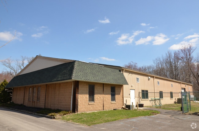
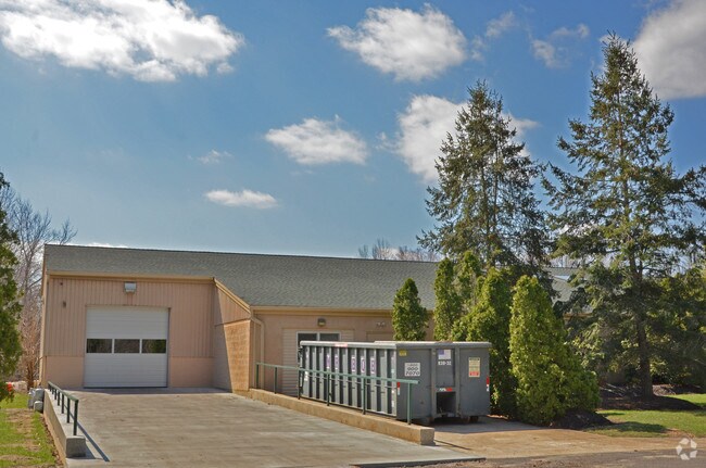
4 Ridge Rd, Southampton, NJ 08088


Property Detail
4 Ridge Rd
33-02203-0000-00026
ADDITIONAL LOTS: 27
Officebuilding
Burlington
HC
New Jersey
A Areas with a 1% annual chance of flooding and a 26% chance of flooding over the life of a 30-year mortgage.
26
2024
3.70 AC
2025
Burlington
703202
Philadelphia
7,460 SF
Philadelphia-Camden-Wilmington, PA-NJ-DE-MD
NEARBY LISTINGS FOR SALE OR LEASE
DEMOGRAPHICS near 4 Ridge Rd
1 mile
3 mile
5 mile
2025 Total Population
673
8,673
32,427
2030 Population
691
8,911
33,397
Pop Growth 2025-2030
+ 2.67%
+ 2.74%
+ 2.99%
Average Age
47
54
46
2025 Total Households
259
4,044
13,083
HH Growth 2025-2030
+ 2.70%
+ 2.87%
+ 3.13%
Median Household Inc
$110,577
$80,079
$105,821
Avg Household Size
2.60
2.10
2.40
2025 Avg HH Vehicles
2.00
2.00
2.00
Median Home Value
$392,646
$313,474
$386,719
Median Year Built
1980
1976
1976
Nearby Places
Map Layers
Map Styles
 Street
 Aerial
Layers
 Traffic
 Biking
Places
Listings with unknown addresses are not visible on the map
- Restaurants
- Banks
- Shops
- Fitness
- Groceries
PUBLIC TRANSPORTATION
AIRPORT
Trenton Mercer
Drive
Walk
Distance
Trenton Mercer
43 min
30.6 mi
Philadelphia International
Drive
Walk
Distance
Philadelphia International
48 min
34.5 mi
Freight Ports
Port of Philadelphia
Drive
Walk
Distance
Port of Philadelphia
33 min
24.6 mi
Nearby Properties
Address
Land Use
TOTAL SIZE
Lot Size
Zoning
Address
Land Use
TOTAL SIZE
Lot Size
Zoning
5.29 AC
TC
Address
Land Use
TOTAL SIZE
Lot Size
Zoning
20,460 SF
23.95 AC
AR
Address
Land Use
TOTAL SIZE
Lot Size
Zoning
1,750 SF
7.91 AC
I
Address
Land Use
TOTAL SIZE
Lot Size
Zoning
5.63 AC
HC
Address
Land Use
TOTAL SIZE
Lot Size
Zoning
8.38 AC
HC
Address
Land Use
TOTAL SIZE
Lot Size
Zoning
0.70 AC
TC
Address
Land Use
TOTAL SIZE
Lot Size
Zoning
Address
Land Use
TOTAL SIZE
Lot Size
Zoning
9.37 AC
I
Address
Land Use
TOTAL SIZE
Lot Size
Zoning
3.45 AC
I
Address
Land Use
TOTAL SIZE
Lot Size
Zoning
31 AC
TCHC
Address
Land Use
TOTAL SIZE
Lot Size
Zoning
0.38 AC
TC
Address
Land Use
TOTAL SIZE
Lot Size
Zoning
24,360 SF
15.77 AC
I
Address
Land Use
TOTAL SIZE
Lot Size
Zoning
15.65 AC
HC
Address
Land Use
TOTAL SIZE
Lot Size
Zoning
9,300 SF
26.36 AC
HC
Address
Land Use
TOTAL SIZE
Lot Size
Zoning
2.09 AC
HC
Address
Land Use
TOTAL SIZE
Lot Size
Zoning
3,366 SF
5 AC
AR
Address
Land Use
TOTAL SIZE
Lot Size
Zoning
16,000 SF
2.40 AC
I
Address
Land Use
TOTAL SIZE
Lot Size
Zoning
50.50 AC
MC
Address
Land Use
TOTAL SIZE
Lot Size
Zoning
5.30 AC
I
Address
Land Use
TOTAL SIZE
Lot Size
Zoning
3.31 AC
Address
Land Use
TOTAL SIZE
Lot Size
Zoning
5,917 SF
1 AC
AR
Address
Land Use
TOTAL SIZE
Lot Size
Zoning
5,349 SF
1 AC
APPL
Address
Land Use
TOTAL SIZE
Lot Size
Zoning
13.60 AC
I
Address
Land Use
TOTAL SIZE
Lot Size
Zoning
3.28 AC
HC
Address
Land Use
TOTAL SIZE
Lot Size
Zoning
1,351 SF
1.38 AC
HC
Address
Land Use
TOTAL SIZE
Lot Size
Zoning
57.69 AC
I
Address
Land Use
TOTAL SIZE
Lot Size
Zoning
8,750 SF
3.13 AC
I
Address
Land Use
TOTAL SIZE
Lot Size
Zoning
4.62 AC
I
Address
Land Use
TOTAL SIZE
Lot Size
Zoning
3.07 AC
HCPL
Address
Land Use
TOTAL SIZE
Lot Size
Zoning
5.29 AC
HC
The World's #1 Commercial Real Estate Marketplace
Connect with us
© 2026 CoStar Group
The information above has been obtained from sources believed reliable. While we do not doubt its accuracy we have not verified it and make no guarantee, warranty or representation about it. It is your responsibility to independently confirm its accuracy and completeness. Any projections, opinions, assumptions, or estimates used are for example only and do not represent the current or future performance of the property. The value of this transaction to you depends on tax and other factors which should be evaluated by your tax, financial, and legal advisors. You and your advisors should conduct a careful, independent investigation of the property to determine to your satisfaction the suitability of the property for your needs.