Property Record
4 Rolens Dr, Kingston, RI 02881

Save to a Folder
{{folder.Name}}
{{folder.ListingIds.length}} Properties
{{folder.ListingIds.length}} Property
Create a New Folder
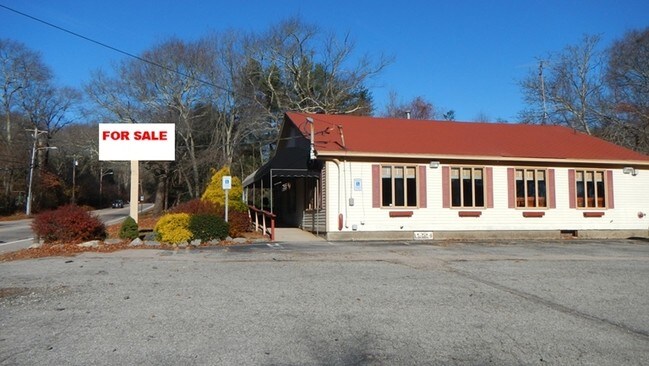
Property Detail
4 Rolens Dr
SKIN-003204-000000-000032
Washington
Apartment
Rhode Island
CN
32
B and X Area of moderate flood hazard, usually the area between the limits of the 100-year and 500-year floods.
1.23 AC
2025
Washington County
2025
Providence
051305
Providence-Warwick, RI-MA
NEARBY LISTINGS FOR SALE OR LEASE
DEMOGRAPHICS near 4 Rolens Dr
1 mile
3 mile
5 mile
2025 Total Population
3,671
22,400
41,599
2030 Population
3,592
21,938
41,273
Pop Growth 2025-2030
(2.15%)
(2.06%)
(0.78%)
Average Age
42
38
42
2025 Total Households
1,358
6,857
14,937
HH Growth 2025-2030
(2.87%)
(2.98%)
(0.97%)
Median Household Inc
$95,203
$105,938
$110,465
Avg Household Size
2.40
2.30
2.30
2025 Avg HH Vehicles
2.00
2.00
2.00
Median Home Value
$528,261
$557,091
$638,013
Median Year Built
1982
1977
1977
Nearby Places
Map Layers
Map Styles
 Street
 Aerial
Layers
 Traffic
 Biking
Places
Listings with unknown addresses are not visible on the map
- Restaurants
- Banks
- Shops
- Fitness
- Groceries
PUBLIC TRANSPORTATION
COMMUTER RAIL
Kingston Amtrak Station (Northeast Regional - Amtrak)
Drive
Walk
Distance
Kingston Amtrak Station (Northeast Regional - Amtrak)
9 min
2.6 mi
AIRPORT
Rhode Island Tf Green International
Drive
Walk
Distance
Rhode Island Tf Green International
43 min
25.5 mi
Freight Ports
Port of Davisville, RI
Drive
Walk
Distance
Port of Davisville, RI
33 min
15.3 mi
Nearby Properties
Address
Land Use
TOTAL SIZE
Lot Size
Zoning
Address
Land Use
TOTAL SIZE
Lot Size
Zoning
8.03 AC
GI
Address
Land Use
TOTAL SIZE
Lot Size
Zoning
16.50 AC
GI
Address
Land Use
TOTAL SIZE
Lot Size
Zoning
245,692 SF
11.12 AC
GI
Address
Land Use
TOTAL SIZE
Lot Size
Zoning
50.78 AC
GI
Address
Land Use
TOTAL SIZE
Lot Size
Zoning
25.32 AC
GI
Address
Land Use
TOTAL SIZE
Lot Size
Zoning
74,782 SF
6.16 AC
MU
Address
Land Use
TOTAL SIZE
Lot Size
Zoning
150.79 AC
GI
Address
Land Use
TOTAL SIZE
Lot Size
Zoning
85,477 SF
6.23 AC
GI
Address
Land Use
TOTAL SIZE
Lot Size
Zoning
340.80 AC
GI
Address
Land Use
TOTAL SIZE
Lot Size
Zoning
6.22 AC
RM
Address
Land Use
TOTAL SIZE
Lot Size
Zoning
6.54 AC
GI
Address
Land Use
TOTAL SIZE
Lot Size
Zoning
4.81 AC
GI
Address
Land Use
TOTAL SIZE
Lot Size
Zoning
6.09 AC
GI
Address
Land Use
TOTAL SIZE
Lot Size
Zoning
4.45 AC
GI
Address
Land Use
TOTAL SIZE
Lot Size
Zoning
57,663 SF
1.45 AC
GI
Address
Land Use
TOTAL SIZE
Lot Size
Zoning
10.03 AC
GI
Address
Land Use
TOTAL SIZE
Lot Size
Zoning
86,735 SF
25 AC
RM
Address
Land Use
TOTAL SIZE
Lot Size
Zoning
4.40 AC
CN
Address
Land Use
TOTAL SIZE
Lot Size
Zoning
282,537 SF
20.22 AC
IND1
Address
Land Use
TOTAL SIZE
Lot Size
Zoning
10.52 AC
GI
Address
Land Use
TOTAL SIZE
Lot Size
Zoning
11.47 AC
IND1
Address
Land Use
TOTAL SIZE
Lot Size
Zoning
1.21 AC
GI
Address
Land Use
TOTAL SIZE
Lot Size
Zoning
63,735 SF
23.79 AC
R20
Address
Land Use
TOTAL SIZE
Lot Size
Zoning
33,614 SF
4.69 AC
R80
Address
Land Use
TOTAL SIZE
Lot Size
Zoning
7.45 AC
RM
Address
Land Use
TOTAL SIZE
Lot Size
Zoning
24,089 SF
5 AC
R40
Address
Land Use
TOTAL SIZE
Lot Size
Zoning
178.20 AC
OS
Address
Land Use
TOTAL SIZE
Lot Size
Zoning
2.70 AC
IND1
Address
Land Use
TOTAL SIZE
Lot Size
Zoning
33,495 SF
4.55 AC
R20
Address
Land Use
TOTAL SIZE
Lot Size
Zoning
2.34 AC
R10
The World's #1 Commercial Real Estate Marketplace
Connect with us
© 2026 CoStar Group
The information above has been obtained from sources believed reliable. While we do not doubt its accuracy we have not verified it and make no guarantee, warranty or representation about it. It is your responsibility to independently confirm its accuracy and completeness. Any projections, opinions, assumptions, or estimates used are for example only and do not represent the current or future performance of the property. The value of this transaction to you depends on tax and other factors which should be evaluated by your tax, financial, and legal advisors. You and your advisors should conduct a careful, independent investigation of the property to determine to your satisfaction the suitability of the property for your needs.