Property Record
4 The Grn, Bethlehem, CT 06751


Save to a Folder
{{folder.Name}}
{{folder.ListingIds.length}} Properties
{{folder.ListingIds.length}} Property
Create a New Folder
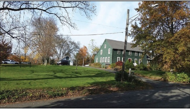
Property Detail
4 The Grn
BETH-000106-000000-000034
Naugatuck Vly
Commercialbuilding
Connecticut
R-1
1.01 AC
2025
New Milford/SW Litchfield
2025
Hartford
342100
Torrington, CT
3,279 SF
NEARBY LISTINGS FOR SALE OR LEASE
-
-
View all Bethlehem listings for sale on LoopNet.com
DEMOGRAPHICS near 4 The Grn
1 mile
3 mile
5 mile
2025 Total Population
1,097
4,675
14,834
2030 Population
1,126
4,807
15,223
Pop Growth 2025-2030
+ 2.64%
+ 2.82%
+ 2.62%
Average Age
47
47
46
2025 Total Households
455
1,888
5,846
HH Growth 2025-2030
+ 2.64%
+ 2.81%
+ 2.62%
Median Household Inc
$104,412
$107,818
$112,116
Avg Household Size
2.30
2.40
2.40
2025 Avg HH Vehicles
2.00
2.00
2.00
Median Home Value
$421,739
$442,826
$428,283
Median Year Built
1969
1969
1971
Nearby Places
Map Layers
Map Styles
 Street
 Aerial
Layers
 Traffic
 Biking
Places
Listings with unknown addresses are not visible on the map
- Restaurants
- Banks
- Shops
- Fitness
- Groceries
SALE & LEASE HISTORY
LISTING DATE
SALE/LEASE

Sep 23, 2016
For Sale
Nearby Properties
Address
Land Use
TOTAL SIZE
Lot Size
Zoning
Address
Land Use
TOTAL SIZE
Lot Size
Zoning
97.74 AC
R-1
Address
Land Use
TOTAL SIZE
Lot Size
Zoning
50.01 AC
R-1
Address
Land Use
TOTAL SIZE
Lot Size
Zoning
48,949 SF
5.06 AC
R-1
Address
Land Use
TOTAL SIZE
Lot Size
Zoning
7.12 AC
R-1
Address
Land Use
TOTAL SIZE
Lot Size
Zoning
58.78 AC
Address
Land Use
TOTAL SIZE
Lot Size
Zoning
94.88 AC
R-1
Address
Land Use
TOTAL SIZE
Lot Size
Zoning
65.50 AC
R-1
Address
Land Use
TOTAL SIZE
Lot Size
Zoning
66.55 AC
R-1
Address
Land Use
TOTAL SIZE
Lot Size
Zoning
16.33 AC
R-1
Address
Land Use
TOTAL SIZE
Lot Size
Zoning
1,440 SF
505.55 AC
L-19
Address
Land Use
TOTAL SIZE
Lot Size
Zoning
14.58 AC
R-1
Address
Land Use
TOTAL SIZE
Lot Size
Zoning
1,200 SF
54 AC
R-1
Address
Land Use
TOTAL SIZE
Lot Size
Zoning
1.75 AC
Address
Land Use
TOTAL SIZE
Lot Size
Zoning
4.47 AC
R-1
Address
Land Use
TOTAL SIZE
Lot Size
Zoning
204.81 AC
R-1
Address
Land Use
TOTAL SIZE
Lot Size
Zoning
16.45 AC
R-1
Address
Land Use
TOTAL SIZE
Lot Size
Zoning
18.52 AC
R-1
Address
Land Use
TOTAL SIZE
Lot Size
Zoning
9.52 AC
R-1
Address
Land Use
TOTAL SIZE
Lot Size
Zoning
42,124 SF
5.51 AC
M
Address
Land Use
TOTAL SIZE
Lot Size
Zoning
19,192 SF
R90
Address
Land Use
TOTAL SIZE
Lot Size
Zoning
41.61 AC
R-1
Address
Land Use
TOTAL SIZE
Lot Size
Zoning
9.46 AC
R-1
Address
Land Use
TOTAL SIZE
Lot Size
Zoning
67.93 AC
R-1
Address
Land Use
TOTAL SIZE
Lot Size
Zoning
25,046 SF
25 AC
R-24
Address
Land Use
TOTAL SIZE
Lot Size
Zoning
2,827 SF
2.69 AC
R-1
Address
Land Use
TOTAL SIZE
Lot Size
Zoning
29.50 AC
R-1
Address
Land Use
TOTAL SIZE
Lot Size
Zoning
7.25 AC
R-1
Address
Land Use
TOTAL SIZE
Lot Size
Zoning
2.79 AC
R-1
Address
Land Use
TOTAL SIZE
Lot Size
Zoning
68.41 AC
R-1
Address
Land Use
TOTAL SIZE
Lot Size
Zoning
5,083 SF
7.10 AC
R-1
The World's #1 Commercial Real Estate Marketplace
Connect with us
© 2026 CoStar Group
The information above has been obtained from sources believed reliable. While we do not doubt its accuracy we have not verified it and make no guarantee, warranty or representation about it. It is your responsibility to independently confirm its accuracy and completeness. Any projections, opinions, assumptions, or estimates used are for example only and do not represent the current or future performance of the property. The value of this transaction to you depends on tax and other factors which should be evaluated by your tax, financial, and legal advisors. You and your advisors should conduct a careful, independent investigation of the property to determine to your satisfaction the suitability of the property for your needs.