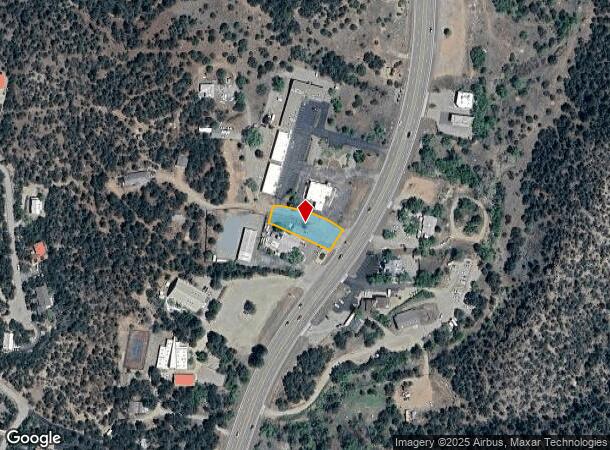
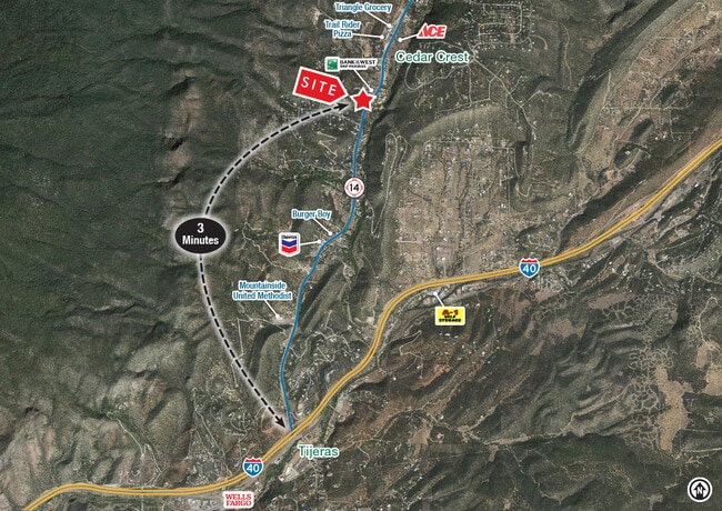
Property Record
4 Unger Rd, Cedar Crest, NM 87008

NEARBY LISTINGS FOR SALE OR LEASE
-
-
View all Cedar Crest listings for lease on LoopNet.com
Property Detail
4 Unger Rd
Albuquerque, NM
Land Div
1-029-060-322145-4-01-08
*1B LAND DIV PLAT LANDS OF RON BUNT CONT 0.36 AC M/L
Storebuilding
Bernalillo
X
New Mexico
35001C0401H
1b
2024
0.23 AC
2025
East Outlying
003805
Albuquerque
672 SF
DEMOGRAPHICS near 4 Unger Rd
1 Mile
3 Mile
5 Mile
2024 Total Population
1,066
3,689
7,391
2029 Population
1,032
3,545
7,142
Pop Growth 2024-2029
(3.19%)
(3.90%)
(3.37%)
Average Age
47
47
47
2024 Total Households
439
1,527
3,050
HH Growth 2024-2029
(3.42%)
(4.13%)
(3.64%)
Median Household Inc
$124,708
$116,321
$111,027
Avg Household Size
2.40
2.40
2.40
2024 Avg HH Vehicles
3.00
3.00
3.00
Median Home Value
$345,098
$353,101
$358,826
Median Year Built
1983
1985
1987
Nearby Places
Map Layers
Map Styles
 Street
 Aerial
- Restaurants
- Banks
- Shops
- Fitness
- Groceries
PUBLIC TRANSPORTATION
AIRPORT
Albuquerque International Sunport
DRIVE
WALK
Distance
Albuquerque International Sunport
35 min
19.4 mi
Freight Ports
Tulsa Port Of Catoosa
DRIVE
WALK
Distance
Tulsa Port Of Catoosa
672 min
648.3 mi
SALE & LEASE HISTORY
LISTING DATE
SALE/LEASE

May 23, 2023
For Lease
Jan 24, 2022
For Sale
Nearby Properties
Address
Land Use
TOTAL SIZE
Lot Size
Zoning
Address
Land Use
TOTAL SIZE
Lot Size
Zoning
Address
Land Use
TOTAL SIZE
Lot Size
Zoning
1.27 AC
Address
Land Use
TOTAL SIZE
Lot Size
Zoning
1,624 SF
2.30 AC
Address
Land Use
TOTAL SIZE
Lot Size
Zoning
Address
Land Use
TOTAL SIZE
Lot Size
Zoning
5.44 AC
Address
Land Use
TOTAL SIZE
Lot Size
Zoning
3,520 SF
18 AC
Address
Land Use
TOTAL SIZE
Lot Size
Zoning
25,795 SF
2.51 AC
Address
Land Use
TOTAL SIZE
Lot Size
Zoning
20.71 AC
Address
Land Use
TOTAL SIZE
Lot Size
Zoning
5,616 SF
8.28 AC
Address
Land Use
TOTAL SIZE
Lot Size
Zoning
Address
Land Use
TOTAL SIZE
Lot Size
Zoning
6,902 SF
3.95 AC
Address
Land Use
TOTAL SIZE
Lot Size
Zoning
14,156 SF
1.60 AC
Address
Land Use
TOTAL SIZE
Lot Size
Zoning
1,529 SF
5.09 AC
Address
Land Use
TOTAL SIZE
Lot Size
Zoning
4.06 AC
Address
Land Use
TOTAL SIZE
Lot Size
Zoning
2,100 SF
10.50 AC
Address
Land Use
TOTAL SIZE
Lot Size
Zoning
2,624 SF
14 AC
Address
Land Use
TOTAL SIZE
Lot Size
Zoning
7,300 SF
1.15 AC
Address
Land Use
TOTAL SIZE
Lot Size
Zoning
7,432 SF
2.47 AC
Address
Land Use
TOTAL SIZE
Lot Size
Zoning
14,043 SF
1.57 AC
Address
Land Use
TOTAL SIZE
Lot Size
Zoning
5,183 SF
21.49 AC
Address
Land Use
TOTAL SIZE
Lot Size
Zoning
5,469 SF
3.70 AC
Address
Land Use
TOTAL SIZE
Lot Size
Zoning
1,800 SF
10 AC
Address
Land Use
TOTAL SIZE
Lot Size
Zoning
8,427 SF
0.89 AC
Address
Land Use
TOTAL SIZE
Lot Size
Zoning
3,807 SF
0.49 AC
Address
Land Use
TOTAL SIZE
Lot Size
Zoning
168.50 AC
Address
Land Use
TOTAL SIZE
Lot Size
Zoning
5,808 SF
4.80 AC
Address
Land Use
TOTAL SIZE
Lot Size
Zoning
4,671 SF
6.36 AC
Address
Land Use
TOTAL SIZE
Lot Size
Zoning
3,858 SF
7.10 AC
Address
Land Use
TOTAL SIZE
Lot Size
Zoning
7,200 SF
1.41 AC
Address
Land Use
TOTAL SIZE
Lot Size
Zoning
2,548 SF
0.79 AC
The World's #1 Commercial Real Estate Marketplace
Connect with us
© 2025 CoStar Group
The information above has been obtained from sources believed reliable. While we do not doubt its accuracy we have not verified it and make no guarantee, warranty or representation about it. It is your responsibility to independently confirm its accuracy and completeness. Any projections, opinions, assumptions, or estimates used are for example only and do not represent the current or future performance of the property. The value of this transaction to you depends on tax and other factors which should be evaluated by your tax, financial, and legal advisors. You and your advisors should conduct a careful, independent investigation of the property to determine to your satisfaction the suitability of the property for your needs.