Property Record
4 Woodward Rd, Columbia, CT 06237
NEARBY LISTINGS FOR SALE OR LEASE
-
-
View all Columbia listings for lease on LoopNet.com
Property Detail
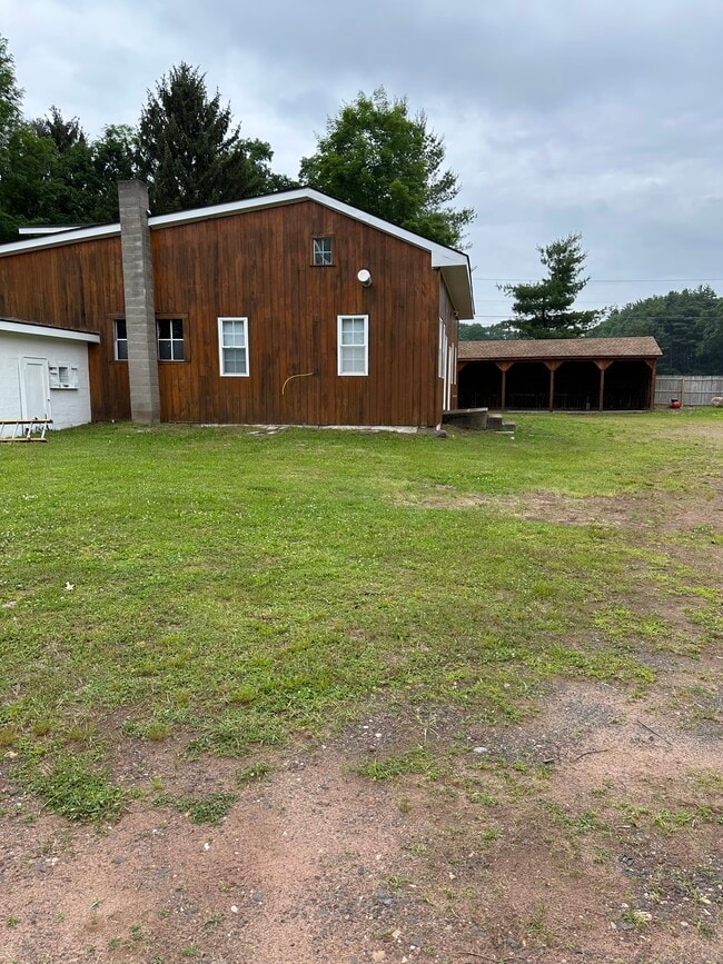
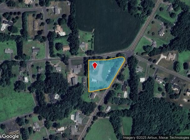
4 Woodward Rd
Industrialgeneral
Tolland
X
Connecticut
25013C0440E
1.54 AC
2025
Tolland County
2025
Hartford
538202
Hartford-West Hartford-East Hartford, CT
1,763 SF
SOME-000007-000000-000063
DEMOGRAPHICS near 4 Woodward Rd
1 Mile
3 Mile
5 Mile
2024 Total Population
1,314
15,894
53,862
2029 Population
1,336
16,086
54,288
Pop Growth 2024-2029
+ 1.67%
+ 1.21%
+ 0.79%
Average Age
44
44
44
2024 Total Households
489
5,436
20,709
HH Growth 2024-2029
+ 1.43%
+ 1.42%
+ 0.85%
Median Household Inc
$104,957
$105,693
$103,063
Avg Household Size
2.70
2.50
2.50
2024 Avg HH Vehicles
2.00
2.00
2.00
Median Home Value
$336,585
$294,635
$283,433
Median Year Built
1973
1970
1967
Nearby Places
Map Layers
Map Styles
 Street
 Aerial
- Restaurants
- Banks
- Shops
- Fitness
- Groceries
PUBLIC TRANSPORTATION
AIRPORT
Bradley International
DRIVE
WALK
Distance
Bradley International
32 min
15.0 mi
Freight Ports
Port of New Haven
DRIVE
WALK
Distance
Port of New Haven
84 min
63.5 mi
SALE & LEASE HISTORY
LISTING DATE
SALE/LEASE

Jun 09, 2025
For Lease
Nearby Properties
Address
Land Use
TOTAL SIZE
Lot Size
Zoning
Address
Land Use
TOTAL SIZE
Lot Size
Zoning
750,000 SF
405 AC
A-1
Address
Land Use
TOTAL SIZE
Lot Size
Zoning
226,545 SF
14 AC
A-1
Address
Land Use
TOTAL SIZE
Lot Size
Zoning
370.78 AC
R88
Address
Land Use
TOTAL SIZE
Lot Size
Zoning
283.30 AC
R88
Address
Land Use
TOTAL SIZE
Lot Size
Zoning
108.50 AC
A-1
Address
Land Use
TOTAL SIZE
Lot Size
Zoning
500,000 SF
71.20 AC
I-1
Address
Land Use
TOTAL SIZE
Lot Size
Zoning
121.07 AC
I-1
Address
Land Use
TOTAL SIZE
Lot Size
Zoning
49.16 AC
I-1
Address
Land Use
TOTAL SIZE
Lot Size
Zoning
36.97 AC
I-1
Address
Land Use
TOTAL SIZE
Lot Size
Zoning
211,256 SF
41.58 AC
R33
Address
Land Use
TOTAL SIZE
Lot Size
Zoning
121 AC
A-1
Address
Land Use
TOTAL SIZE
Lot Size
Zoning
57,328 SF
11.15 AC
INDG
Address
Land Use
TOTAL SIZE
Lot Size
Zoning
111,890 SF
22.08 AC
INDG
Address
Land Use
TOTAL SIZE
Lot Size
Zoning
78,835 SF
5.94 AC
Address
Land Use
TOTAL SIZE
Lot Size
Zoning
152.20 AC
A-1
Address
Land Use
TOTAL SIZE
Lot Size
Zoning
104,111 SF
11.16 AC
I-1
Address
Land Use
TOTAL SIZE
Lot Size
Zoning
53,850 SF
8.12 AC
R33
Address
Land Use
TOTAL SIZE
Lot Size
Zoning
90,776 SF
23.48 AC
I-1
Address
Land Use
TOTAL SIZE
Lot Size
Zoning
169,680 SF
11.49 AC
I-1
Address
Land Use
TOTAL SIZE
Lot Size
Zoning
47,756 SF
6.17 AC
R33
Address
Land Use
TOTAL SIZE
Lot Size
Zoning
9,948 SF
77.88 AC
A
Address
Land Use
TOTAL SIZE
Lot Size
Zoning
67.24 AC
R88
Address
Land Use
TOTAL SIZE
Lot Size
Zoning
2.20 AC
A-1
Address
Land Use
TOTAL SIZE
Lot Size
Zoning
8.10 AC
B
Address
Land Use
TOTAL SIZE
Lot Size
Zoning
16,282 SF
11 AC
A-1
Address
Land Use
TOTAL SIZE
Lot Size
Zoning
2,746 SF
45.08 AC
R88
Address
Land Use
TOTAL SIZE
Lot Size
Zoning
181.46 AC
I-1
Address
Land Use
TOTAL SIZE
Lot Size
Zoning
18.66 AC
Address
Land Use
TOTAL SIZE
Lot Size
Zoning
39,296 SF
4.77 AC
INDG
Address
Land Use
TOTAL SIZE
Lot Size
Zoning
20,208 SF
2 AC
A-1
The World's #1 Commercial Real Estate Marketplace
Connect with us
© 2025 CoStar Group
The information above has been obtained from sources believed reliable. While we do not doubt its accuracy we have not verified it and make no guarantee, warranty or representation about it. It is your responsibility to independently confirm its accuracy and completeness. Any projections, opinions, assumptions, or estimates used are for example only and do not represent the current or future performance of the property. The value of this transaction to you depends on tax and other factors which should be evaluated by your tax, financial, and legal advisors. You and your advisors should conduct a careful, independent investigation of the property to determine to your satisfaction the suitability of the property for your needs.