Property Record
40 3Rd St, Walnutport, PA 18088


Current Lease Availabilities
NEARBY LISTINGS FOR SALE OR LEASE
Property Detail
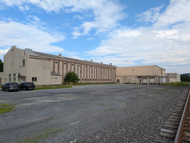
40 3Rd St
Manufacturinglight
Northampton
X
Pennsylvania
42095C0088E
3 AC
2025
Lehigh Valley
2025
Philadelphia
016002
Allentown-Bethlehem-Easton, PA-NJ
164,211 SF
J2SW1B-2-5-1033
DEMOGRAPHICS near 40 3Rd St
1 Mile
3 Mile
5 Mile
2024 Total Population
6,990
14,220
35,677
2029 Population
7,060
14,340
35,896
Pop Growth 2024-2029
+ 1.00%
+ 0.84%
+ 0.61%
Average Age
41
43
44
2024 Total Households
2,909
5,866
14,446
HH Growth 2024-2029
+ 1.00%
+ 0.87%
+ 0.63%
Median Household Inc
$56,721
$62,919
$71,784
Avg Household Size
2.40
2.40
2.40
2024 Avg HH Vehicles
2.00
2.00
2.00
Median Home Value
$186,462
$217,705
$233,890
Median Year Built
1958
1970
1971
Nearby Places
Map Layers
Map Styles
 Street
 Aerial
- Restaurants
- Banks
- Shops
- Fitness
- Groceries
PUBLIC TRANSPORTATION
AIRPORT
Lehigh Valley International
DRIVE
WALK
Distance
Lehigh Valley International
25 min
15.5 mi
Freight Ports
Port of Philadelphia
DRIVE
WALK
Distance
Port of Philadelphia
95 min
71.2 mi
Nearby Properties
Address
Land Use
TOTAL SIZE
Lot Size
Zoning
Address
Land Use
TOTAL SIZE
Lot Size
Zoning
101,962 SF
28.02 AC
SR
Address
Land Use
TOTAL SIZE
Lot Size
Zoning
112,243 SF
18 AC
SR
Address
Land Use
TOTAL SIZE
Lot Size
Zoning
71,582 SF
11.90 AC
RR
Address
Land Use
TOTAL SIZE
Lot Size
Zoning
61,636 SF
2.70 AC
TR
Address
Land Use
TOTAL SIZE
Lot Size
Zoning
784.80 AC
BM
Address
Land Use
TOTAL SIZE
Lot Size
Zoning
25,767 SF
0.39 AC
TC
Address
Land Use
TOTAL SIZE
Lot Size
Zoning
17,636 SF
2.51 AC
SR
Address
Land Use
TOTAL SIZE
Lot Size
Zoning
7,396 SF
175.58 AC
BM
Address
Land Use
TOTAL SIZE
Lot Size
Zoning
15,655 SF
11.32 AC
BM
Address
Land Use
TOTAL SIZE
Lot Size
Zoning
11,029 SF
4.79 AC
TR
Address
Land Use
TOTAL SIZE
Lot Size
Zoning
235,207 SF
11.35 AC
I
Address
Land Use
TOTAL SIZE
Lot Size
Zoning
5,534 SF
181.51 AC
BM
Address
Land Use
TOTAL SIZE
Lot Size
Zoning
12,192 SF
0.24 AC
TR
Address
Land Use
TOTAL SIZE
Lot Size
Zoning
118,072 SF
12.69 AC
R40
Address
Land Use
TOTAL SIZE
Lot Size
Zoning
15,589 SF
15.86 AC
GI
Address
Land Use
TOTAL SIZE
Lot Size
Zoning
9,220 SF
1.95 AC
RR
Address
Land Use
TOTAL SIZE
Lot Size
Zoning
9,840 SF
3.26 AC
RR
Address
Land Use
TOTAL SIZE
Lot Size
Zoning
8,774 SF
3.05 AC
C
Address
Land Use
TOTAL SIZE
Lot Size
Zoning
20,261 SF
4.40 AC
C
Address
Land Use
TOTAL SIZE
Lot Size
Zoning
3,751 SF
56.46 AC
I
Address
Land Use
TOTAL SIZE
Lot Size
Zoning
12,803 SF
0.93 AC
TR
Address
Land Use
TOTAL SIZE
Lot Size
Zoning
7,968 SF
0.40 AC
TR
Address
Land Use
TOTAL SIZE
Lot Size
Zoning
56,250 SF
5.36 AC
C
Address
Land Use
TOTAL SIZE
Lot Size
Zoning
44.92 AC
RA
Address
Land Use
TOTAL SIZE
Lot Size
Zoning
7,104 SF
3.18 AC
TR
Address
Land Use
TOTAL SIZE
Lot Size
Zoning
132.20 AC
BM
Address
Land Use
TOTAL SIZE
Lot Size
Zoning
5,460 SF
0.26 AC
TC
Address
Land Use
TOTAL SIZE
Lot Size
Zoning
4,984 SF
0.19 AC
TR
Address
Land Use
TOTAL SIZE
Lot Size
Zoning
53,708 SF
5.65 AC
C
Address
Land Use
TOTAL SIZE
Lot Size
Zoning
29.19 AC
SR
The World's #1 Commercial Real Estate Marketplace
Connect with us
© 2025 CoStar Group
The information above has been obtained from sources believed reliable. While we do not doubt its accuracy we have not verified it and make no guarantee, warranty or representation about it. It is your responsibility to independently confirm its accuracy and completeness. Any projections, opinions, assumptions, or estimates used are for example only and do not represent the current or future performance of the property. The value of this transaction to you depends on tax and other factors which should be evaluated by your tax, financial, and legal advisors. You and your advisors should conduct a careful, independent investigation of the property to determine to your satisfaction the suitability of the property for your needs.