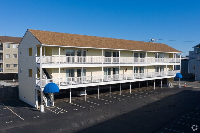
Property Record
40 Ashworth Ave, Hampton, NH 03842

NEARBY LISTINGS FOR SALE OR LEASE
-
-
View all Hampton listings for sale on LoopNet.com
Property Detail
40 Ashworth Ave
Commercialnec
Rockingham
AE
New Hampshire
33015C0437F
1.30 AC
2025
Portsmouth
2025
Boston
065008
Boston-Cambridge-Newton, MA-NH
5,120 SF
HMPT-000282-000000-000204
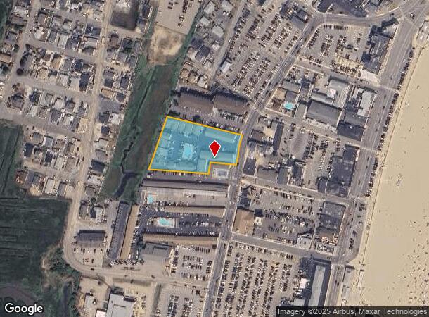
DEMOGRAPHICS near 40 Ashworth Ave
1 mile
3 mile
5 mile
2024 Total Population
4,225
19,098
37,602
2029 Population
4,694
20,396
39,705
Pop Growth 2024-2029
+ 11.10%
+ 6.80%
+ 5.59%
Average Age
52
50
48
2024 Total Households
2,287
9,193
17,074
HH Growth 2024-2029
+ 11.02%
+ 7.02%
+ 5.80%
Median Household Inc
$72,253
$94,198
$96,825
Avg Household Size
1.70
2.00
2.10
2024 Avg HH Vehicles
2.00
2.00
2.00
Median Home Value
$496,580
$493,959
$477,437
Median Year Built
1969
1976
1979
Nearby Places
Map Layers
Map Styles
 Street
 Aerial
Transit
 Traffic
 Biking
Places
Listings with unknown addresses are not visible on the map
- Restaurants
- Banks
- Shops
- Fitness
- Groceries
PUBLIC TRANSPORTATION
AIRPORT
Portsmouth International at Pease
Drive
Walk
Distance
Portsmouth International at Pease
27 min
15.7 mi
Manchester Boston Regional
Drive
Walk
Distance
Manchester Boston Regional
60 min
43.3 mi
SALE & LEASE HISTORY
LISTING DATE
SALE/LEASE

Oct 05, 2023
For Sale
May 31, 2023
For Sale
Nearby Properties
Address
Land Use
TOTAL SIZE
Lot Size
Zoning
Address
Land Use
TOTAL SIZE
Lot Size
Zoning
4,884 SF
40 AC
RB
Address
Land Use
TOTAL SIZE
Lot Size
Zoning
46,328 SF
49.50 AC
RA
Address
Land Use
TOTAL SIZE
Lot Size
Zoning
120,362 SF
32.29 AC
LA4
Address
Land Use
TOTAL SIZE
Lot Size
Zoning
112,708 SF
40 AC
50
Address
Land Use
TOTAL SIZE
Lot Size
Zoning
116,112 SF
4.52 AC
BS1
Address
Land Use
TOTAL SIZE
Lot Size
Zoning
179,840 SF
13.46 AC
LA4
Address
Land Use
TOTAL SIZE
Lot Size
Zoning
142,369 SF
8.82 AC
POR
Address
Land Use
TOTAL SIZE
Lot Size
Zoning
79,305 SF
17.18 AC
G
Address
Land Use
TOTAL SIZE
Lot Size
Zoning
850 SF
0.94 AC
BS
Address
Land Use
TOTAL SIZE
Lot Size
Zoning
25,867 SF
9.17 AC
BS
Address
Land Use
TOTAL SIZE
Lot Size
Zoning
577.79 AC
I2
Address
Land Use
TOTAL SIZE
Lot Size
Zoning
70,876 SF
17.38 AC
RA
Address
Land Use
TOTAL SIZE
Lot Size
Zoning
11,338 SF
28.90 AC
I
Address
Land Use
TOTAL SIZE
Lot Size
Zoning
29,408 SF
9.49 AC
RB
Address
Land Use
TOTAL SIZE
Lot Size
Zoning
41,864 SF
7.50 AC
RA
Address
Land Use
TOTAL SIZE
Lot Size
Zoning
47,508 SF
4.94 AC
TC-S
Address
Land Use
TOTAL SIZE
Lot Size
Zoning
57,215 SF
4.40 AC
TOWN C
Address
Land Use
TOTAL SIZE
Lot Size
Zoning
52,319 SF
5.90 AC
POR
Address
Land Use
TOTAL SIZE
Lot Size
Zoning
18,228 SF
4.10 AC
TC-S
Address
Land Use
TOTAL SIZE
Lot Size
Zoning
42,828 SF
4.69 AC
LA2
Address
Land Use
TOTAL SIZE
Lot Size
Zoning
26,928 SF
25.11 AC
G
Address
Land Use
TOTAL SIZE
Lot Size
Zoning
56,520 SF
6.46 AC
BUSINE
Address
Land Use
TOTAL SIZE
Lot Size
Zoning
9,150 SF
0.24 AC
RA
Address
Land Use
TOTAL SIZE
Lot Size
Zoning
26,652 SF
23.60 AC
I
Address
Land Use
TOTAL SIZE
Lot Size
Zoning
44,860 SF
5.54 AC
TC-N
Address
Land Use
TOTAL SIZE
Lot Size
Zoning
6,892 SF
5.70 AC
B
Address
Land Use
TOTAL SIZE
Lot Size
Zoning
12,479 SF
0.47 AC
O1
Address
Land Use
TOTAL SIZE
Lot Size
Zoning
33,771 SF
0.41 AC
BS
Address
Land Use
TOTAL SIZE
Lot Size
Zoning
7,588 SF
0.74 AC
O1
The World's #1 Commercial Real Estate Marketplace
Connect with us
© 2026 CoStar Group
The information above has been obtained from sources believed reliable. While we do not doubt its accuracy we have not verified it and make no guarantee, warranty or representation about it. It is your responsibility to independently confirm its accuracy and completeness. Any projections, opinions, assumptions, or estimates used are for example only and do not represent the current or future performance of the property. The value of this transaction to you depends on tax and other factors which should be evaluated by your tax, financial, and legal advisors. You and your advisors should conduct a careful, independent investigation of the property to determine to your satisfaction the suitability of the property for your needs.