Property Record
40 Beaver Creek Rd E, Apex, NC 27502

Property Detail
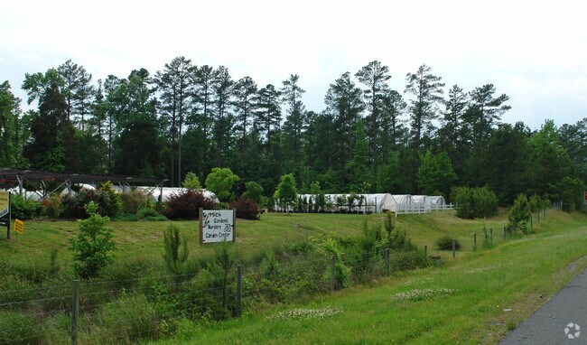
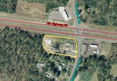
40 Beaver Creek Rd E
17707
P5-5 AC 2.147 BK 95 PG 263
Restaurantbuilding
CHATHAM
B-1
North Carolina
B and X Area of moderate flood hazard, usually the area between the limits of the 100-year and 500-year floods.
2.15 AC
2025
Chatham County
2025
Raleigh/Durham
020702
Durham-Chapel Hill, NC
756 SF
NEARBY LISTINGS FOR SALE OR LEASE
-
-
View all Apex listings for sale on LoopNet.com
DEMOGRAPHICS near 40 Beaver Creek Rd E
1 mile
3 mile
5 mile
2025 Total Population
115
1,237
16,894
2030 Population
126
1,361
18,904
Pop Growth 2025-2030
+ 9.57%
+ 10.02%
+ 11.90%
Average Age
46
45
40
2025 Total Households
46
498
5,877
HH Growth 2025-2030
+ 8.70%
+ 10.04%
+ 12.12%
Median Household Inc
$116,666
$115,393
$161,375
Avg Household Size
2.30
2.40
2.80
2025 Avg HH Vehicles
3.00
3.00
2.00
Median Home Value
$673,077
$705,026
$733,966
Median Year Built
1993
1995
2010
Nearby Places
Map Layers
Map Styles
 Street
 Aerial
Transit
 Traffic
 Biking
Places
Listings with unknown addresses are not visible on the map
- Restaurants
- Banks
- Shops
- Fitness
- Groceries
PUBLIC TRANSPORTATION
AIRPORT
Raleigh-Durham International
Drive
Walk
Distance
Raleigh-Durham International
29 min
20.4 mi
Freight Ports
Port of Wilmington
Drive
Walk
Distance
Port of Wilmington
178 min
152.9 mi
Nearby Properties
Address
Land Use
TOTAL SIZE
Lot Size
Zoning
Address
Land Use
TOTAL SIZE
Lot Size
Zoning
22,534 SF
20.01 AC
CD-RB
Address
Land Use
TOTAL SIZE
Lot Size
Zoning
39,040 SF
42.75 AC
CD-IL
Address
Land Use
TOTAL SIZE
Lot Size
Zoning
83.23 AC
M-1
Address
Land Use
TOTAL SIZE
Lot Size
Zoning
28,089 SF
16.40 AC
R-80W
Address
Land Use
TOTAL SIZE
Lot Size
Zoning
16,840 SF
25.72 AC
CD-RB
Address
Land Use
TOTAL SIZE
Lot Size
Zoning
1,350 SF
38.11 AC
MH-NC
Address
Land Use
TOTAL SIZE
Lot Size
Zoning
23,973 SF
3.30 AC
R-1
Address
Land Use
TOTAL SIZE
Lot Size
Zoning
12,000 SF
15.34 AC
CU-B-1
Address
Land Use
TOTAL SIZE
Lot Size
Zoning
2,000 SF
14.19 AC
M-1
Address
Land Use
TOTAL SIZE
Lot Size
Zoning
12,000 SF
2.04 AC
CD-CB
Address
Land Use
TOTAL SIZE
Lot Size
Zoning
33.66 AC
R-1
Address
Land Use
TOTAL SIZE
Lot Size
Zoning
35,960 SF
5.35 AC
CU-B-1
Address
Land Use
TOTAL SIZE
Lot Size
Zoning
5,784 SF
1.44 AC
B-1
Address
Land Use
TOTAL SIZE
Lot Size
Zoning
7,650 SF
6.76 AC
CD-CB
Address
Land Use
TOTAL SIZE
Lot Size
Zoning
2,738 SF
24.56 AC
R-1
Address
Land Use
TOTAL SIZE
Lot Size
Zoning
11.72 AC
M-1
Address
Land Use
TOTAL SIZE
Lot Size
Zoning
13,767 SF
0.24 AC
CU-IND-L
Address
Land Use
TOTAL SIZE
Lot Size
Zoning
10.83 AC
M-1
Address
Land Use
TOTAL SIZE
Lot Size
Zoning
2,078 SF
13.88 AC
R-1
Address
Land Use
TOTAL SIZE
Lot Size
Zoning
23,656 SF
3.42 AC
CD-NB
Address
Land Use
TOTAL SIZE
Lot Size
Zoning
36.34 AC
R-1
Address
Land Use
TOTAL SIZE
Lot Size
Zoning
9,375 SF
4.99 AC
R-1
Address
Land Use
TOTAL SIZE
Lot Size
Zoning
6,930 SF
16.58 AC
R-1
Address
Land Use
TOTAL SIZE
Lot Size
Zoning
2,164 SF
104.07 AC
R-1
Address
Land Use
TOTAL SIZE
Lot Size
Zoning
7,275 SF
2.10 AC
R-1
Address
Land Use
TOTAL SIZE
Lot Size
Zoning
3,572 SF
3.56 AC
B-1
Address
Land Use
TOTAL SIZE
Lot Size
Zoning
3,000 SF
4.90 AC
R-1
Address
Land Use
TOTAL SIZE
Lot Size
Zoning
6,600 SF
15 AC
CU-B-1
Address
Land Use
TOTAL SIZE
Lot Size
Zoning
4,800 SF
4.77 AC
B-1
Address
Land Use
TOTAL SIZE
Lot Size
Zoning
2,462 SF
4.42 AC
R-1
The World's #1 Commercial Real Estate Marketplace
Connect with us
© 2026 CoStar Group
The information above has been obtained from sources believed reliable. While we do not doubt its accuracy we have not verified it and make no guarantee, warranty or representation about it. It is your responsibility to independently confirm its accuracy and completeness. Any projections, opinions, assumptions, or estimates used are for example only and do not represent the current or future performance of the property. The value of this transaction to you depends on tax and other factors which should be evaluated by your tax, financial, and legal advisors. You and your advisors should conduct a careful, independent investigation of the property to determine to your satisfaction the suitability of the property for your needs.