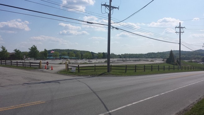
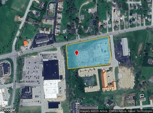
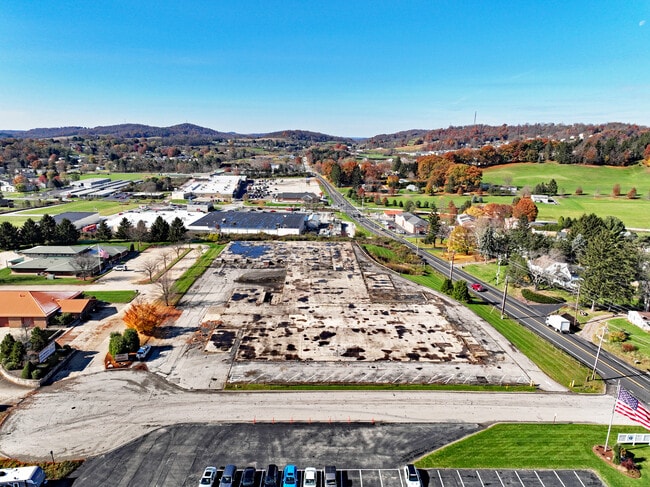
Property Record
40 Christy Park Dr, Indiana, PA 15701
NEARBY LISTINGS FOR SALE OR LEASE
Property Detail
40 Christy Park Dr
42-016-126.14
AC= 3.37 1 CB
Commercialacreage
Indiana
X
Pennsylvania
42063C0381F
3.37 AC
2025
Pennsylvania Central Area
2025
Other Market Areas
960700
Indiana, PA
DEMOGRAPHICS near 40 Christy Park Dr
1 Mile
3 Mile
5 Mile
2024 Total Population
6,189
27,644
33,933
2029 Population
6,275
27,690
33,936
Pop Growth 2024-2029
+ 1.39%
+ 0.17%
+ 0.01%
Average Age
42
38
39
2024 Total Households
2,986
10,938
13,064
HH Growth 2024-2029
+ 1.34%
+ 0.17%
(0.01%)
Median Household Inc
$61,880
$47,347
$50,723
Avg Household Size
2.00
2.10
2.10
2024 Avg HH Vehicles
2.00
2.00
2.00
Median Home Value
$194,188
$160,401
$160,770
Median Year Built
1979
1971
1971
Nearby Places
Map Layers
Map Styles
 Street
 Aerial
- Restaurants
- Banks
- Shops
- Fitness
- Groceries
PUBLIC TRANSPORTATION
AIRPORT
Arnold Palmer Regional
DRIVE
WALK
Distance
Arnold Palmer Regional
52 min
34.1 mi
Freight Ports
Port of Baltimore
DRIVE
WALK
Distance
Port of Baltimore
270 min
221.6 mi
SALE & LEASE HISTORY
LISTING DATE
SALE/LEASE

Sep 17, 2024
For Sale
Sep 12, 2023
For Sale
Nearby Properties
Address
Land Use
TOTAL SIZE
Lot Size
Zoning
Address
Land Use
TOTAL SIZE
Lot Size
Zoning
68,928 SF
7.83 AC
Address
Land Use
TOTAL SIZE
Lot Size
Zoning
92,892 SF
60.52 AC
Address
Land Use
TOTAL SIZE
Lot Size
Zoning
250,984 SF
3 AC
Address
Land Use
TOTAL SIZE
Lot Size
Zoning
70,284 SF
28.33 AC
Address
Land Use
TOTAL SIZE
Lot Size
Zoning
100,000 SF
11.44 AC
Address
Land Use
TOTAL SIZE
Lot Size
Zoning
3,015 SF
27.71 AC
Address
Land Use
TOTAL SIZE
Lot Size
Zoning
38,241 SF
18.07 AC
Address
Land Use
TOTAL SIZE
Lot Size
Zoning
41,436 SF
10.80 AC
Address
Land Use
TOTAL SIZE
Lot Size
Zoning
38,440 SF
2.06 AC
Address
Land Use
TOTAL SIZE
Lot Size
Zoning
28,828 SF
1.13 AC
Address
Land Use
TOTAL SIZE
Lot Size
Zoning
81,431 SF
5.68 AC
Address
Land Use
TOTAL SIZE
Lot Size
Zoning
57,760 SF
1.43 AC
Address
Land Use
TOTAL SIZE
Lot Size
Zoning
9,180 SF
22.93 AC
Address
Land Use
TOTAL SIZE
Lot Size
Zoning
43,644 SF
1.24 AC
Address
Land Use
TOTAL SIZE
Lot Size
Zoning
28,812 SF
2.48 AC
Address
Land Use
TOTAL SIZE
Lot Size
Zoning
116,124 SF
5.02 AC
Address
Land Use
TOTAL SIZE
Lot Size
Zoning
153,074 SF
Address
Land Use
TOTAL SIZE
Lot Size
Zoning
56,960 SF
2.17 AC
Address
Land Use
TOTAL SIZE
Lot Size
Zoning
28,743 SF
1.66 AC
Address
Land Use
TOTAL SIZE
Lot Size
Zoning
63,744 SF
1.15 AC
Address
Land Use
TOTAL SIZE
Lot Size
Zoning
78,655 SF
2.77 AC
Address
Land Use
TOTAL SIZE
Lot Size
Zoning
51,320 SF
1.52 AC
Address
Land Use
TOTAL SIZE
Lot Size
Zoning
50,922 SF
1.53 AC
Address
Land Use
TOTAL SIZE
Lot Size
Zoning
56,842 SF
1.58 AC
Address
Land Use
TOTAL SIZE
Lot Size
Zoning
60,080 SF
0.65 AC
Address
Land Use
TOTAL SIZE
Lot Size
Zoning
46,546 SF
15 AC
Address
Land Use
TOTAL SIZE
Lot Size
Zoning
76,806 SF
Address
Land Use
TOTAL SIZE
Lot Size
Zoning
800 SF
39.69 AC
Address
Land Use
TOTAL SIZE
Lot Size
Zoning
63,532 SF
4.39 AC
The World's #1 Commercial Real Estate Marketplace
Connect with us
© 2025 CoStar Group
The information above has been obtained from sources believed reliable. While we do not doubt its accuracy we have not verified it and make no guarantee, warranty or representation about it. It is your responsibility to independently confirm its accuracy and completeness. Any projections, opinions, assumptions, or estimates used are for example only and do not represent the current or future performance of the property. The value of this transaction to you depends on tax and other factors which should be evaluated by your tax, financial, and legal advisors. You and your advisors should conduct a careful, independent investigation of the property to determine to your satisfaction the suitability of the property for your needs.