Property Record
40 E 64Th St, Holland, MI 49423
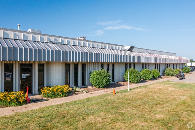

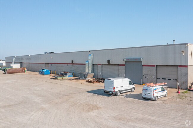
Property Detail
40 E 64Th St
53-02-17-200-023
UNIT 1 GENZINK INDUSTRIAL CENTER ACCORDING TO FIRST AMENDMENT TO MASTER DEED SEC 17 T4N R15W (2021). SPLIT/COMBINED ON 01/21/2021 FROM 53-02-17-200-008, 53-02-17-200-009, 53-02-17-200-010, 53-02-17-200-011, 53-02-17-200-012, 53-02-17-200-013;
Manufacturinglight
Allegan
B and X Area of moderate flood hazard, usually the area between the limits of the 100-year and 500-year floods.
Michigan
2024
9.85 AC
2025
NE Allegan/Holland
032401
West Michigan
86,062 SF
Holland, MI
NEARBY LISTINGS FOR SALE OR LEASE
DEMOGRAPHICS near 40 E 64Th St
1 mile
3 mile
5 mile
2025 Total Population
140
20,597
53,714
2030 Population
141
20,691
54,641
Pop Growth 2025-2030
+ 0.71%
+ 0.46%
+ 1.73%
Average Age
41
40
40
2025 Total Households
53
7,965
20,294
HH Growth 2025-2030
+ 1.89%
+ 0.44%
+ 1.84%
Median Household Inc
$80,469
$72,406
$75,973
Avg Household Size
2.60
2.50
2.50
2025 Avg HH Vehicles
2.00
2.00
2.00
Median Home Value
$287,499
$252,547
$282,613
Median Year Built
1980
1968
1973
Nearby Places
Map Layers
Map Styles
 Street
 Aerial
Transit
 Traffic
 Biking
Places
Listings with unknown addresses are not visible on the map
- Restaurants
- Banks
- Shops
- Fitness
- Groceries
PUBLIC TRANSPORTATION
COMMUTER RAIL
Drive
Walk
Distance
11 min
4.3 mi
AIRPORT
Gerald R Ford International
Drive
Walk
Distance
Gerald R Ford International
49 min
37.5 mi
Nearby Properties
Address
Land Use
TOTAL SIZE
Lot Size
Zoning
Address
Land Use
TOTAL SIZE
Lot Size
Zoning
1,599,294 SF
Address
Land Use
TOTAL SIZE
Lot Size
Zoning
1,788,352 SF
173.33 AC
Address
Land Use
TOTAL SIZE
Lot Size
Zoning
682,378 SF
99.60 AC
NA
Address
Land Use
TOTAL SIZE
Lot Size
Zoning
198,712 SF
Address
Land Use
TOTAL SIZE
Lot Size
Zoning
630,943 SF
28.50 AC
Address
Land Use
TOTAL SIZE
Lot Size
Zoning
556,819 SF
85.45 AC
Address
Land Use
TOTAL SIZE
Lot Size
Zoning
674,052 SF
79.30 AC
Address
Land Use
TOTAL SIZE
Lot Size
Zoning
154,107 SF
Address
Land Use
TOTAL SIZE
Lot Size
Zoning
239,465 SF
Address
Land Use
TOTAL SIZE
Lot Size
Zoning
118,444 SF
4.39 AC
Address
Land Use
TOTAL SIZE
Lot Size
Zoning
589,649 SF
92.65 AC
Address
Land Use
TOTAL SIZE
Lot Size
Zoning
150,822 SF
Address
Land Use
TOTAL SIZE
Lot Size
Zoning
114,088 SF
10.79 AC
PRD
Address
Land Use
TOTAL SIZE
Lot Size
Zoning
181,754 SF
13.44 AC
R3
Address
Land Use
TOTAL SIZE
Lot Size
Zoning
391,842 SF
28.34 AC
Address
Land Use
TOTAL SIZE
Lot Size
Zoning
372,017 SF
17.60 AC
R-2
Address
Land Use
TOTAL SIZE
Lot Size
Zoning
357,000 SF
23.35 AC
Address
Land Use
TOTAL SIZE
Lot Size
Zoning
73,700 SF
Address
Land Use
TOTAL SIZE
Lot Size
Zoning
397,258 SF
36.66 AC
I2
Address
Land Use
TOTAL SIZE
Lot Size
Zoning
158,661 SF
17.28 AC
Address
Land Use
TOTAL SIZE
Lot Size
Zoning
146,357 SF
20.04 AC
Address
Land Use
TOTAL SIZE
Lot Size
Zoning
73,663 SF
4.66 AC
Address
Land Use
TOTAL SIZE
Lot Size
Zoning
252,065 SF
13.98 AC
Address
Land Use
TOTAL SIZE
Lot Size
Zoning
404,600 SF
23.23 AC
I2
Address
Land Use
TOTAL SIZE
Lot Size
Zoning
132,108 SF
9.97 AC
I-1
Address
Land Use
TOTAL SIZE
Lot Size
Zoning
281,775 SF
Address
Land Use
TOTAL SIZE
Lot Size
Zoning
124,176 SF
7.88 AC
I
Address
Land Use
TOTAL SIZE
Lot Size
Zoning
55,088 SF
Address
Land Use
TOTAL SIZE
Lot Size
Zoning
300,000 SF
Address
Land Use
TOTAL SIZE
Lot Size
Zoning
140,700 SF
20.28 AC
The World's #1 Commercial Real Estate Marketplace
Connect with us
© 2026 CoStar Group
The information above has been obtained from sources believed reliable. While we do not doubt its accuracy we have not verified it and make no guarantee, warranty or representation about it. It is your responsibility to independently confirm its accuracy and completeness. Any projections, opinions, assumptions, or estimates used are for example only and do not represent the current or future performance of the property. The value of this transaction to you depends on tax and other factors which should be evaluated by your tax, financial, and legal advisors. You and your advisors should conduct a careful, independent investigation of the property to determine to your satisfaction the suitability of the property for your needs.