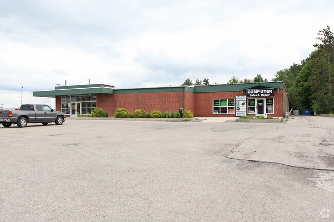
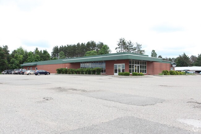
Property Record
40 E 82Nd St, Newaygo, MI 49337

Property Detail
40 E 82Nd St
19-30-160-026
LOTS 1, 2, 3, & 4 EDGEWOOD
Storebuilding
Newaygo
LOCAL ZONE
Michigan
B and X Area of moderate flood hazard, usually the area between the limits of the 100-year and 500-year floods.
1-4
2025
2.49 AC
2025
Newaygo County
971100
West Michigan
20,498 SF
NEARBY LISTINGS FOR SALE OR LEASE
DEMOGRAPHICS near 40 E 82Nd St
1 mile
3 mile
5 mile
2025 Total Population
2,071
6,541
11,571
2030 Population
2,111
6,765
11,917
Pop Growth 2025-2030
+ 1.93%
+ 3.42%
+ 2.99%
Average Age
38
41
41
2025 Total Households
771
2,513
4,406
HH Growth 2025-2030
+ 1.82%
+ 3.46%
+ 3.09%
Median Household Inc
$56,048
$65,471
$67,699
Avg Household Size
2.50
2.50
2.50
2025 Avg HH Vehicles
2.00
2.00
2.00
Median Home Value
$181,360
$216,538
$222,899
Median Year Built
1985
1982
1981
Nearby Places
Map Layers
Map Styles
 Street
 Aerial
Transit
 Traffic
 Biking
Places
Listings with unknown addresses are not visible on the map
- Restaurants
- Banks
- Shops
- Fitness
- Groceries
Nearby Properties
Address
Land Use
TOTAL SIZE
Lot Size
Zoning
Address
Land Use
TOTAL SIZE
Lot Size
Zoning
Address
Land Use
TOTAL SIZE
Lot Size
Zoning
54,366 SF
7.70 AC
LOCAL ZONE
Address
Land Use
TOTAL SIZE
Lot Size
Zoning
173,880 SF
27 AC
LOCAL ZONE
Address
Land Use
TOTAL SIZE
Lot Size
Zoning
Address
Land Use
TOTAL SIZE
Lot Size
Zoning
8 AC
LOCAL ZONE
Address
Land Use
TOTAL SIZE
Lot Size
Zoning
114,376 SF
21.20 AC
LOCAL ZONE
Address
Land Use
TOTAL SIZE
Lot Size
Zoning
46,733 SF
6.75 AC
LOCAL ZONE
Address
Land Use
TOTAL SIZE
Lot Size
Zoning
57,044 SF
606.89 AC
LOCAL ZONE
Address
Land Use
TOTAL SIZE
Lot Size
Zoning
46,611 SF
10.83 AC
LOCAL ZONE
Address
Land Use
TOTAL SIZE
Lot Size
Zoning
9,452 SF
15.95 AC
LOCAL ZONE
Address
Land Use
TOTAL SIZE
Lot Size
Zoning
35,502 SF
3.12 AC
LOCAL ZONE
Address
Land Use
TOTAL SIZE
Lot Size
Zoning
40,636 SF
10 AC
LOCAL ZONE
Address
Land Use
TOTAL SIZE
Lot Size
Zoning
1,200 SF
39.83 AC
LOCAL ZONE
Address
Land Use
TOTAL SIZE
Lot Size
Zoning
6,178 SF
7.49 AC
LOCAL ZONE
Address
Land Use
TOTAL SIZE
Lot Size
Zoning
25,200 SF
3.30 AC
LOCAL ZONE
Address
Land Use
TOTAL SIZE
Lot Size
Zoning
Address
Land Use
TOTAL SIZE
Lot Size
Zoning
67,240 SF
12.80 AC
LOCAL ZONE
Address
Land Use
TOTAL SIZE
Lot Size
Zoning
85,653 SF
5.17 AC
LOCAL ZONE
Address
Land Use
TOTAL SIZE
Lot Size
Zoning
33 AC
LOCAL ZONE
Address
Land Use
TOTAL SIZE
Lot Size
Zoning
15.43 AC
R1
Address
Land Use
TOTAL SIZE
Lot Size
Zoning
3,374 SF
1.19 AC
LOCAL ZONE
Address
Land Use
TOTAL SIZE
Lot Size
Zoning
2,824 SF
0.48 AC
LOCAL ZONE
Address
Land Use
TOTAL SIZE
Lot Size
Zoning
2,455 SF
1.08 AC
LOCAL ZONE
Address
Land Use
TOTAL SIZE
Lot Size
Zoning
28,608 SF
4.37 AC
LOCAL ZONE
Address
Land Use
TOTAL SIZE
Lot Size
Zoning
0.04 AC
LOCAL ZONE
Address
Land Use
TOTAL SIZE
Lot Size
Zoning
2,092 SF
35 AC
LOCAL ZONE
Address
Land Use
TOTAL SIZE
Lot Size
Zoning
3,304 SF
1.01 AC
LOCAL ZONE
Address
Land Use
TOTAL SIZE
Lot Size
Zoning
Address
Land Use
TOTAL SIZE
Lot Size
Zoning
3,052 SF
1.40 AC
LOCAL ZONE
Address
Land Use
TOTAL SIZE
Lot Size
Zoning
8,827 SF
1.82 AC
LOCAL ZONE
The World's #1 Commercial Real Estate Marketplace
Connect with us
© 2026 CoStar Group
The information above has been obtained from sources believed reliable. While we do not doubt its accuracy we have not verified it and make no guarantee, warranty or representation about it. It is your responsibility to independently confirm its accuracy and completeness. Any projections, opinions, assumptions, or estimates used are for example only and do not represent the current or future performance of the property. The value of this transaction to you depends on tax and other factors which should be evaluated by your tax, financial, and legal advisors. You and your advisors should conduct a careful, independent investigation of the property to determine to your satisfaction the suitability of the property for your needs.