Property Record
Avenue J8/Vic Shiloh Lane, Lancaster, CA 93535

This Property Is For Sale
Property Detail
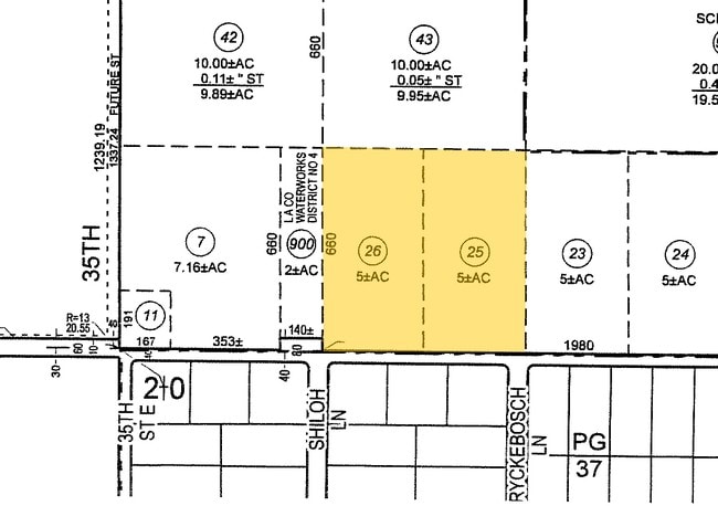
Avenue J8/Vic Shiloh Lane
3150-013-049
W 1/2 OF SE 1/4 OF SW 1/4 OF NE 1/4 EX O F ST OF SEC 20 T7N R11W
Residentialacreage
LOS ANGELES
LRSRR*
California
C and X Area of minimal flood hazard, usually depicted on FIRMs as above the 500-year flood level.
4.83 AC
2024
Antelope Valley
2025
Los Angeles
900508
Los Angeles-Long Beach-Glendale, CA
NEARBY LISTINGS FOR SALE OR LEASE
DEMOGRAPHICS near Avenue J8/Vic Shiloh Lane
1 mile
3 mile
5 mile
2025 Total Population
5,970
53,536
95,130
2030 Population
5,904
53,323
95,460
Pop Growth 2025-2030
(1.11%)
(0.40%)
+ 0.35%
Average Age
35
36
36
2025 Total Households
1,530
15,069
29,216
HH Growth 2025-2030
(1.31%)
(0.60%)
+ 0.52%
Median Household Inc
$83,799
$71,578
$63,065
Avg Household Size
3.60
3.40
3.10
2025 Avg HH Vehicles
2.00
2.00
2.00
Median Home Value
$428,018
$353,026
$342,284
Median Year Built
1992
1986
1984
Nearby Places
Map Layers
Map Styles
 Street
 Aerial
Transit
 Traffic
 Biking
Places
Listings with unknown addresses are not visible on the map
- Restaurants
- Banks
- Shops
- Fitness
- Groceries
PUBLIC TRANSPORTATION
COMMUTER RAIL
Lancaster (Antelope Valley Line - Southern California Regional Rail Authority (Metrolink))
Drive
Walk
Distance
Lancaster (Antelope Valley Line - Southern California Regional Rail Authority (Metrolink))
8 min
5.0 mi
Freight Ports
Port of Long Beach
Drive
Walk
Distance
Port of Long Beach
116 min
97.5 mi
Nearby Properties
Address
Land Use
TOTAL SIZE
Lot Size
Zoning
Address
Land Use
TOTAL SIZE
Lot Size
Zoning
106,569 SF
38.45 AC
LRRR2.5
Address
Land Use
TOTAL SIZE
Lot Size
Zoning
81,668 SF
5.67 AC
LRRPD65002
Address
Land Use
TOTAL SIZE
Lot Size
Zoning
876,730 SF
20.85 AC
LRCP
Address
Land Use
TOTAL SIZE
Lot Size
Zoning
481,066 SF
11.88 AC
LRRA7500*
Address
Land Use
TOTAL SIZE
Lot Size
Zoning
58,986 SF
4.11 AC
LRRPD65002
Address
Land Use
TOTAL SIZE
Lot Size
Zoning
1,256 SF
158.45 AC
PDM2 1/2*
Address
Land Use
TOTAL SIZE
Lot Size
Zoning
153,664 SF
9.23 AC
Address
Land Use
TOTAL SIZE
Lot Size
Zoning
56,016 SF
5.26 AC
LRRPD65002
Address
Land Use
TOTAL SIZE
Lot Size
Zoning
113,960 SF
9 AC
LRD21*
Address
Land Use
TOTAL SIZE
Lot Size
Zoning
42,668 SF
3.49 AC
LRCPD
Address
Land Use
TOTAL SIZE
Lot Size
Zoning
111,336 SF
8.54 AC
LRR17500*
Address
Land Use
TOTAL SIZE
Lot Size
Zoning
25,162 SF
4.26 AC
LRA22*
Address
Land Use
TOTAL SIZE
Lot Size
Zoning
15,126 SF
1.24 AC
LRC3*
Address
Land Use
TOTAL SIZE
Lot Size
Zoning
14,535 SF
1.69 AC
LRC4-RA650
Address
Land Use
TOTAL SIZE
Lot Size
Zoning
144,800 SF
9.19 AC
LRRA7500*
Address
Land Use
TOTAL SIZE
Lot Size
Zoning
10.15 AC
LRMUC
Address
Land Use
TOTAL SIZE
Lot Size
Zoning
19,100 SF
1.83 AC
LRCPD
Address
Land Use
TOTAL SIZE
Lot Size
Zoning
50,550 SF
4.72 AC
LRC3-RA750
Address
Land Use
TOTAL SIZE
Lot Size
Zoning
15,212 SF
1.29 AC
LRC3-RA750
Address
Land Use
TOTAL SIZE
Lot Size
Zoning
7,859 SF
0.85 AC
LRCPD*
Address
Land Use
TOTAL SIZE
Lot Size
Zoning
76,064 SF
6.08 AC
LRC3-R325U
Address
Land Use
TOTAL SIZE
Lot Size
Zoning
27,268 SF
19.86 AC
LCA22*
Address
Land Use
TOTAL SIZE
Lot Size
Zoning
3,874 SF
38.70 AC
PDM2 1/2-A
Address
Land Use
TOTAL SIZE
Lot Size
Zoning
4,587 SF
0.69 AC
LRRA7500*
Address
Land Use
TOTAL SIZE
Lot Size
Zoning
3,062 SF
0.69 AC
LRCP
Address
Land Use
TOTAL SIZE
Lot Size
Zoning
29,052 SF
3.06 AC
LRC3-RA650
Address
Land Use
TOTAL SIZE
Lot Size
Zoning
7,731 SF
0.84 AC
LRCP
Address
Land Use
TOTAL SIZE
Lot Size
Zoning
38.55 AC
PDMI
Address
Land Use
TOTAL SIZE
Lot Size
Zoning
27,776 SF
1.89 AC
LRR315U*
Address
Land Use
TOTAL SIZE
Lot Size
Zoning
15,168 SF
1.64 AC
LRC3-RA750
The World's #1 Commercial Real Estate Marketplace
Connect with us
© 2026 CoStar Group
The information above has been obtained from sources believed reliable. While we do not doubt its accuracy we have not verified it and make no guarantee, warranty or representation about it. It is your responsibility to independently confirm its accuracy and completeness. Any projections, opinions, assumptions, or estimates used are for example only and do not represent the current or future performance of the property. The value of this transaction to you depends on tax and other factors which should be evaluated by your tax, financial, and legal advisors. You and your advisors should conduct a careful, independent investigation of the property to determine to your satisfaction the suitability of the property for your needs.