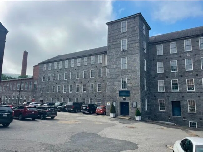
Property Record
40 E Main St, Ware, MA 01082


Current Lease Availabilities
Property Detail
40 E Main St
WARE-000057-000000-000113
HAMPSHIRE
Commercialofficeresidentialmixeduse
Massachusetts
MY
113
2025
0.89 AC
2025
Hampshire County
820102
Hartford
29,778 SF
Amherst Town-Northampton, MA
NEARBY LISTINGS FOR SALE OR LEASE
DEMOGRAPHICS near 40 E Main St
1 mile
3 mile
5 mile
2024 Total Population
5,257
9,110
18,540
2029 Population
5,265
9,165
18,763
Pop Growth 2024-2029
+ 0.15%
+ 0.60%
+ 1.20%
Average Age
41
42
43
2024 Total Households
2,293
3,923
7,819
HH Growth 2024-2029
+ 0.31%
+ 0.79%
+ 1.36%
Median Household Inc
$54,014
$63,524
$67,653
Avg Household Size
2.20
2.30
2.30
2024 Avg HH Vehicles
1.00
2.00
2.00
Median Home Value
$232,353
$264,403
$315,374
Median Year Built
1951
1966
1966
Nearby Places
Map Layers
Map Styles
 Street
 Aerial
Transit
 Traffic
 Biking
Places
Listings with unknown addresses are not visible on the map
- Restaurants
- Banks
- Shops
- Fitness
- Groceries
PUBLIC TRANSPORTATION
AIRPORT
Worcester Regional
Drive
Walk
Distance
Worcester Regional
48 min
25.9 mi
Freight Ports
Port of Davisville, RI
Drive
Walk
Distance
Port of Davisville, RI
119 min
84.7 mi
Nearby Properties
Address
Land Use
TOTAL SIZE
Lot Size
Zoning
Address
Land Use
TOTAL SIZE
Lot Size
Zoning
197,466 SF
41 AC
RB
Address
Land Use
TOTAL SIZE
Lot Size
Zoning
110,982 SF
6.08 AC
SR
Address
Land Use
TOTAL SIZE
Lot Size
Zoning
162,818 SF
21.37 AC
CI
Address
Land Use
TOTAL SIZE
Lot Size
Zoning
131,737 SF
20.78 AC
CI
Address
Land Use
TOTAL SIZE
Lot Size
Zoning
277,467 SF
9.87 AC
I
Address
Land Use
TOTAL SIZE
Lot Size
Zoning
780 SF
2,295.68 AC
RQ
Address
Land Use
TOTAL SIZE
Lot Size
Zoning
90,406 SF
12.14 AC
DTR
Address
Land Use
TOTAL SIZE
Lot Size
Zoning
88,170 SF
6 AC
DTR
Address
Land Use
TOTAL SIZE
Lot Size
Zoning
58,131 SF
47.36 AC
RR
Address
Land Use
TOTAL SIZE
Lot Size
Zoning
50,567 SF
5.15 AC
SR
Address
Land Use
TOTAL SIZE
Lot Size
Zoning
166,000 SF
13.28 AC
I
Address
Land Use
TOTAL SIZE
Lot Size
Zoning
56,238 SF
3.59 AC
HC
Address
Land Use
TOTAL SIZE
Lot Size
Zoning
25,042 SF
3.70 AC
CI
Address
Land Use
TOTAL SIZE
Lot Size
Zoning
55,633 SF
8.59 AC
HC
Address
Land Use
TOTAL SIZE
Lot Size
Zoning
21,635 SF
0.46 AC
DTC
Address
Land Use
TOTAL SIZE
Lot Size
Zoning
29,576 SF
0.54 AC
DTC
Address
Land Use
TOTAL SIZE
Lot Size
Zoning
18,075 SF
4.38 AC
HC
Address
Land Use
TOTAL SIZE
Lot Size
Zoning
17,146 SF
0.26 AC
DTC
Address
Land Use
TOTAL SIZE
Lot Size
Zoning
41,966 SF
2.88 AC
DTR
Address
Land Use
TOTAL SIZE
Lot Size
Zoning
10,874 SF
8 AC
I
Address
Land Use
TOTAL SIZE
Lot Size
Zoning
14,262 SF
2.59 AC
HC
Address
Land Use
TOTAL SIZE
Lot Size
Zoning
27,282 SF
1.15 AC
SR
Address
Land Use
TOTAL SIZE
Lot Size
Zoning
26,080 SF
3.96 AC
HC
Address
Land Use
TOTAL SIZE
Lot Size
Zoning
18,000 SF
1.73 AC
HC
Address
Land Use
TOTAL SIZE
Lot Size
Zoning
20,757 SF
4 AC
SR
Address
Land Use
TOTAL SIZE
Lot Size
Zoning
13,080 SF
6.74 AC
HC
Address
Land Use
TOTAL SIZE
Lot Size
Zoning
14,578 SF
1.72 AC
DTR
Address
Land Use
TOTAL SIZE
Lot Size
Zoning
90,194 SF
3 AC
DTC
Address
Land Use
TOTAL SIZE
Lot Size
Zoning
16,609 SF
7 AC
HC
Address
Land Use
TOTAL SIZE
Lot Size
Zoning
121 SF
11.47 AC
RR
The World's #1 Commercial Real Estate Marketplace
Connect with us
© 2026 CoStar Group
The information above has been obtained from sources believed reliable. While we do not doubt its accuracy we have not verified it and make no guarantee, warranty or representation about it. It is your responsibility to independently confirm its accuracy and completeness. Any projections, opinions, assumptions, or estimates used are for example only and do not represent the current or future performance of the property. The value of this transaction to you depends on tax and other factors which should be evaluated by your tax, financial, and legal advisors. You and your advisors should conduct a careful, independent investigation of the property to determine to your satisfaction the suitability of the property for your needs.