Property Record
40 Farrington Rd, Brewster, NY 10509
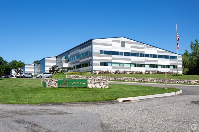

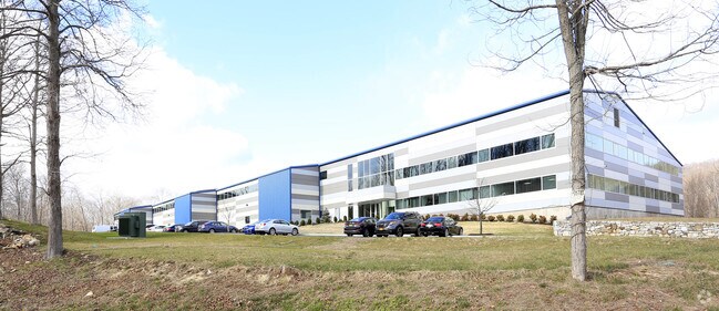
Property Detail
40 Farrington Rd
373089-068-000-0002-017-000-0000
Putnam
Warehouse
New York
SR 6
17.00
B and X Area of moderate flood hazard, usually the area between the limits of the 100-year and 500-year floods.
6.46 AC
2024
Brewster
2025
Westchester/So Connecticut
011900
New York-Jersey City-White Plains, NY-NJ
48,443 SF
NEARBY LISTINGS FOR SALE OR LEASE
DEMOGRAPHICS near 40 Farrington Rd
1 mile
3 mile
5 mile
2025 Total Population
466
16,584
44,383
2030 Population
459
16,844
45,019
Pop Growth 2025-2030
(1.50%)
+ 1.57%
+ 1.43%
Average Age
44
43
43
2025 Total Households
168
6,629
16,554
HH Growth 2025-2030
(1.19%)
+ 1.98%
+ 1.60%
Median Household Inc
$150,735
$115,371
$122,370
Avg Household Size
2.70
2.50
2.60
2025 Avg HH Vehicles
3.00
2.00
2.00
Median Home Value
$636,111
$526,576
$499,321
Median Year Built
1966
1982
1977
Nearby Places
Map Layers
Map Styles
 Street
 Aerial
Layers
 Traffic
 Biking
Places
Listings with unknown addresses are not visible on the map
- Restaurants
- Banks
- Shops
- Fitness
- Groceries
PUBLIC TRANSPORTATION
COMMUTER RAIL
Brewster Station (Harlem Line - Metro-North Commuter Railroad Company (Metro-North))
Drive
Walk
Distance
Brewster Station (Harlem Line - Metro-North Commuter Railroad Company (Metro-North))
5 min
3.2 mi
Southeast Station (Harlem Line - Metro-North Commuter Railroad Company (Metro-North))
Drive
Walk
Distance
Southeast Station (Harlem Line - Metro-North Commuter Railroad Company (Metro-North))
15 min
7.1 mi
AIRPORT
Westchester County
Drive
Walk
Distance
Westchester County
35 min
27.7 mi
New York Stewart International
Drive
Walk
Distance
New York Stewart International
52 min
38.9 mi
Freight Ports
Port of New Haven
Drive
Walk
Distance
Port of New Haven
64 min
43.3 mi
Nearby Properties
Address
Land Use
TOTAL SIZE
Lot Size
Zoning
Address
Land Use
TOTAL SIZE
Lot Size
Zoning
23,091 SF
84.73 AC
R160
Address
Land Use
TOTAL SIZE
Lot Size
Zoning
1,078.50 AC
SR 6
Address
Land Use
TOTAL SIZE
Lot Size
Zoning
505.03 AC
PND
Address
Land Use
TOTAL SIZE
Lot Size
Zoning
670.72 AC
SP Z
Address
Land Use
TOTAL SIZE
Lot Size
Zoning
47.39 AC
PND
Address
Land Use
TOTAL SIZE
Lot Size
Zoning
32.98 AC
PND
Address
Land Use
TOTAL SIZE
Lot Size
Zoning
146,484 SF
23.06 AC
SR 22
Address
Land Use
TOTAL SIZE
Lot Size
Zoning
196,513 SF
PND
Address
Land Use
TOTAL SIZE
Lot Size
Zoning
196,544 SF
PND
Address
Land Use
TOTAL SIZE
Lot Size
Zoning
10.44 AC
CA80
Address
Land Use
TOTAL SIZE
Lot Size
Zoning
13.39 AC
RMF-6
Address
Land Use
TOTAL SIZE
Lot Size
Zoning
99,900 SF
21.48 AC
OP1
Address
Land Use
TOTAL SIZE
Lot Size
Zoning
Address
Land Use
TOTAL SIZE
Lot Size
Zoning
67.30 AC
Address
Land Use
TOTAL SIZE
Lot Size
Zoning
1.16 AC
SR 6
Address
Land Use
TOTAL SIZE
Lot Size
Zoning
136,073 SF
PND
Address
Land Use
TOTAL SIZE
Lot Size
Zoning
135,929 SF
PND
Address
Land Use
TOTAL SIZE
Lot Size
Zoning
134,436 SF
99.53 AC
PND
Address
Land Use
TOTAL SIZE
Lot Size
Zoning
134,407 SF
PND
Address
Land Use
TOTAL SIZE
Lot Size
Zoning
42.30 AC
Address
Land Use
TOTAL SIZE
Lot Size
Zoning
201,776 SF
34 AC
IL40
Address
Land Use
TOTAL SIZE
Lot Size
Zoning
3.98 AC
IL40
Address
Land Use
TOTAL SIZE
Lot Size
Zoning
22,338 SF
2.37 AC
C
Address
Land Use
TOTAL SIZE
Lot Size
Zoning
Address
Land Use
TOTAL SIZE
Lot Size
Zoning
2.03 AC
C
Address
Land Use
TOTAL SIZE
Lot Size
Zoning
59,257 SF
21 AC
SR 6
Address
Land Use
TOTAL SIZE
Lot Size
Zoning
3,060 SF
2.47 AC
R40
Address
Land Use
TOTAL SIZE
Lot Size
Zoning
29,847 SF
5.86 AC
PND
Address
Land Use
TOTAL SIZE
Lot Size
Zoning
2,168 SF
51.21 AC
RAAA
Address
Land Use
TOTAL SIZE
Lot Size
Zoning
63,221 SF
10 AC
SP Z
The World's #1 Commercial Real Estate Marketplace
Connect with us
© 2026 CoStar Group
The information above has been obtained from sources believed reliable. While we do not doubt its accuracy we have not verified it and make no guarantee, warranty or representation about it. It is your responsibility to independently confirm its accuracy and completeness. Any projections, opinions, assumptions, or estimates used are for example only and do not represent the current or future performance of the property. The value of this transaction to you depends on tax and other factors which should be evaluated by your tax, financial, and legal advisors. You and your advisors should conduct a careful, independent investigation of the property to determine to your satisfaction the suitability of the property for your needs.