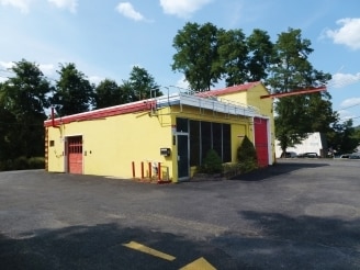
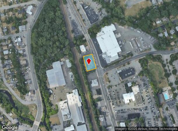
Property Record
40 Franklin Tpke, Mahwah, NJ 07430
NEARBY LISTINGS FOR SALE OR LEASE
-
-
-
-
No Photo
-
View all Mahwah listings for sale on LoopNet.com
Property Detail
40 Franklin Tpke
New York-Jersey City-White Plains, NY-NJ
150X100 4LT (30,2-B-1)
33-00068-0000-00005
Bergen
Commercialnec
New Jersey
X
5
34003C0057H
0.34 AC
2024
North 17 Corridor
2025
Northern New Jersey
032202
DEMOGRAPHICS near 40 Franklin Tpke
1 Mile
3 Mile
5 Mile
2024 Total Population
12,725
48,318
134,618
2029 Population
12,637
48,267
134,265
Pop Growth 2024-2029
(0.69%)
(0.11%)
(0.26%)
Average Age
41
43
36
2024 Total Households
4,951
18,643
41,036
HH Growth 2024-2029
(0.69%)
(0.13%)
(0.18%)
Median Household Inc
$100,362
$106,003
$101,762
Avg Household Size
2.50
2.50
3.10
2024 Avg HH Vehicles
2.00
2.00
2.00
Median Home Value
$379,479
$481,835
$653,399
Median Year Built
1968
1977
1975
Nearby Places
Map Layers
Map Styles
 Street
 Aerial
- Restaurants
- Banks
- Shops
- Fitness
- Groceries
PUBLIC TRANSPORTATION
COMMUTER RAIL
Suffern (Bergen County/Port Jervis Line - NJ Transit Commuter Rail (NJ Transit), Main/Port Jervis Line - NJ Transit Commuter Rail (NJ Transit))
DRIVE
WALK
Distance
Suffern (Bergen County/Port Jervis Line - NJ Transit Commuter Rail (NJ Transit), Main/Port Jervis Line - NJ Transit Commuter Rail (NJ Transit))
2 min
15 min
0.8 mi
Mahwah (Bergen County/Port Jervis Line - NJ Transit Commuter Rail (NJ Transit), Main/Port Jervis Line - NJ Transit Commuter Rail (NJ Transit))
DRIVE
WALK
Distance
Mahwah (Bergen County/Port Jervis Line - NJ Transit Commuter Rail (NJ Transit), Main/Port Jervis Line - NJ Transit Commuter Rail (NJ Transit))
1 min
16 min
0.8 mi
AIRPORT
Westchester County
DRIVE
WALK
Distance
Westchester County
44 min
31.2 mi
LaGuardia
DRIVE
WALK
Distance
LaGuardia
50 min
32.9 mi
New York Stewart International
DRIVE
WALK
Distance
New York Stewart International
47 min
35.9 mi
Freight Ports
Port Newark Container Terminal
DRIVE
WALK
Distance
Port Newark Container Terminal
49 min
34.9 mi
SALE & LEASE HISTORY
LISTING DATE
SALE/LEASE

Sep 23, 2016
For Sale
Oct 21, 2016
For Sale
Mar 08, 2017
For Sale
Nearby Properties
Address
Land Use
TOTAL SIZE
Lot Size
Zoning
Address
Land Use
TOTAL SIZE
Lot Size
Zoning
284 AC
P40
Address
Land Use
TOTAL SIZE
Lot Size
Zoning
28.44 AC
Address
Land Use
TOTAL SIZE
Lot Size
Zoning
28.28 AC
GI80
Address
Land Use
TOTAL SIZE
Lot Size
Zoning
39.50 AC
Address
Land Use
TOTAL SIZE
Lot Size
Zoning
46.89 AC
IP120
Address
Land Use
TOTAL SIZE
Lot Size
Zoning
1,056 SF
99.35 AC
OP200
Address
Land Use
TOTAL SIZE
Lot Size
Zoning
61.37 AC
PED
Address
Land Use
TOTAL SIZE
Lot Size
Zoning
17.71 AC
B3
Address
Land Use
TOTAL SIZE
Lot Size
Zoning
7.11 AC
Address
Land Use
TOTAL SIZE
Lot Size
Zoning
23.32 AC
Address
Land Use
TOTAL SIZE
Lot Size
Zoning
10.38 AC
Address
Land Use
TOTAL SIZE
Lot Size
Zoning
6.52 AC
Address
Land Use
TOTAL SIZE
Lot Size
Zoning
17.90 AC
IP
Address
Land Use
TOTAL SIZE
Lot Size
Zoning
2.33 AC
B3
Address
Land Use
TOTAL SIZE
Lot Size
Zoning
20 AC
ORP200
Address
Land Use
TOTAL SIZE
Lot Size
Zoning
170,941 SF
10.04 AC
IP
Address
Land Use
TOTAL SIZE
Lot Size
Zoning
14.09 AC
B200
Address
Land Use
TOTAL SIZE
Lot Size
Zoning
106,836 SF
8.85 AC
LO
Address
Land Use
TOTAL SIZE
Lot Size
Zoning
Address
Land Use
TOTAL SIZE
Lot Size
Zoning
15.98 AC
Address
Land Use
TOTAL SIZE
Lot Size
Zoning
15.30 AC
R1
Address
Land Use
TOTAL SIZE
Lot Size
Zoning
133,140 SF
8.10 AC
B3
Address
Land Use
TOTAL SIZE
Lot Size
Zoning
68.78 AC
OP20
Address
Land Use
TOTAL SIZE
Lot Size
Zoning
146,442 SF
7.97 AC
LO
Address
Land Use
TOTAL SIZE
Lot Size
Zoning
92,851 SF
8.66 AC
Address
Land Use
TOTAL SIZE
Lot Size
Zoning
20.26 AC
Address
Land Use
TOTAL SIZE
Lot Size
Zoning
19.60 AC
OP200
Address
Land Use
TOTAL SIZE
Lot Size
Zoning
5.67 AC
Address
Land Use
TOTAL SIZE
Lot Size
Zoning
6.76 AC
IP120
Address
Land Use
TOTAL SIZE
Lot Size
Zoning
33.78 AC
CEDR40
The World's #1 Commercial Real Estate Marketplace
Connect with us
© 2025 CoStar Group
The information above has been obtained from sources believed reliable. While we do not doubt its accuracy we have not verified it and make no guarantee, warranty or representation about it. It is your responsibility to independently confirm its accuracy and completeness. Any projections, opinions, assumptions, or estimates used are for example only and do not represent the current or future performance of the property. The value of this transaction to you depends on tax and other factors which should be evaluated by your tax, financial, and legal advisors. You and your advisors should conduct a careful, independent investigation of the property to determine to your satisfaction the suitability of the property for your needs.