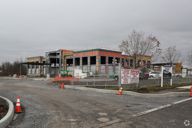
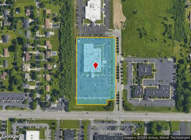
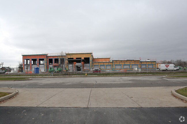
Property Record
40 George Karl Blvd, Buffalo, NY 14221

NEARBY LISTINGS FOR SALE OR LEASE
Property Detail
40 George Karl Blvd
142289 81.02-2-12.12
Erie
Professionalbldglegalinsurancerealestateetc
New York
X
12.120
36029C0229H
5 AC
2025
East
2024
Buffalo/Niagara Falls
009601
Buffalo-Cheektowaga, NY
60,268 SF
DEMOGRAPHICS near 40 George Karl Blvd
1 Mile
3 Mile
5 Mile
2024 Total Population
3,398
61,865
175,685
2029 Population
3,391
61,786
175,506
Pop Growth 2024-2029
(0.21%)
(0.13%)
(0.10%)
Average Age
44
45
43
2024 Total Households
1,489
27,109
74,034
HH Growth 2024-2029
(0.13%)
(0.19%)
(0.20%)
Median Household Inc
$90,364
$78,320
$81,856
Avg Household Size
2.20
2.20
2.30
2024 Avg HH Vehicles
2.00
2.00
2.00
Median Home Value
$259,431
$231,468
$232,721
Median Year Built
1989
1967
1965
Nearby Places
Map Layers
Map Styles
 Street
 Aerial
- Restaurants
- Banks
- Shops
- Fitness
- Groceries
PUBLIC TRANSPORTATION
COMMUTER RAIL
DRIVE
WALK
Distance
11 min
5.1 mi
DRIVE
WALK
Distance
13 min
5.6 mi
AIRPORT
Buffalo Niagara International
DRIVE
WALK
Distance
Buffalo Niagara International
7 min
2.1 mi
Niagara Falls International
DRIVE
WALK
Distance
Niagara Falls International
35 min
18.7 mi
Nearby Properties
Address
Land Use
TOTAL SIZE
Lot Size
Zoning
Address
Land Use
TOTAL SIZE
Lot Size
Zoning
462,256 SF
568.62 AC
05C
Address
Land Use
TOTAL SIZE
Lot Size
Zoning
308,191 SF
19.74 AC
CF
Address
Land Use
TOTAL SIZE
Lot Size
Zoning
Address
Land Use
TOTAL SIZE
Lot Size
Zoning
322,151 SF
44.99 AC
Address
Land Use
TOTAL SIZE
Lot Size
Zoning
24,600 SF
19.20 AC
00000
Address
Land Use
TOTAL SIZE
Lot Size
Zoning
176,108 SF
20.04 AC
GB
Address
Land Use
TOTAL SIZE
Lot Size
Zoning
82,802 SF
12.80 AC
05C
Address
Land Use
TOTAL SIZE
Lot Size
Zoning
172,400 SF
116.50 AC
Address
Land Use
TOTAL SIZE
Lot Size
Zoning
82.29 AC
05C
Address
Land Use
TOTAL SIZE
Lot Size
Zoning
260,326 SF
22.70 AC
Address
Land Use
TOTAL SIZE
Lot Size
Zoning
203,546 SF
13.55 AC
Address
Land Use
TOTAL SIZE
Lot Size
Zoning
216,724 SF
66.09 AC
05C
Address
Land Use
TOTAL SIZE
Lot Size
Zoning
12,576 SF
18.15 AC
Address
Land Use
TOTAL SIZE
Lot Size
Zoning
2,173 SF
15.33 AC
Address
Land Use
TOTAL SIZE
Lot Size
Zoning
Address
Land Use
TOTAL SIZE
Lot Size
Zoning
8,296 SF
16.60 AC
Address
Land Use
TOTAL SIZE
Lot Size
Zoning
172,001 SF
23.49 AC
Address
Land Use
TOTAL SIZE
Lot Size
Zoning
Address
Land Use
TOTAL SIZE
Lot Size
Zoning
3,630 SF
10.50 AC
Address
Land Use
TOTAL SIZE
Lot Size
Zoning
7,744 SF
17.82 AC
Address
Land Use
TOTAL SIZE
Lot Size
Zoning
196,113 SF
21.09 AC
Address
Land Use
TOTAL SIZE
Lot Size
Zoning
54,109 SF
6.19 AC
OB
Address
Land Use
TOTAL SIZE
Lot Size
Zoning
Address
Land Use
TOTAL SIZE
Lot Size
Zoning
124,407 SF
10.38 AC
SC
Address
Land Use
TOTAL SIZE
Lot Size
Zoning
722,642 SF
46.80 AC
05C
Address
Land Use
TOTAL SIZE
Lot Size
Zoning
11,520 SF
8.70 AC
Address
Land Use
TOTAL SIZE
Lot Size
Zoning
211,647 SF
1.76 AC
GB
Address
Land Use
TOTAL SIZE
Lot Size
Zoning
19,558 SF
11.07 AC
Address
Land Use
TOTAL SIZE
Lot Size
Zoning
146,776 SF
9.19 AC
Address
Land Use
TOTAL SIZE
Lot Size
Zoning
19,640 SF
13.34 AC
00000
The World's #1 Commercial Real Estate Marketplace
Connect with us
© 2026 CoStar Group
The information above has been obtained from sources believed reliable. While we do not doubt its accuracy we have not verified it and make no guarantee, warranty or representation about it. It is your responsibility to independently confirm its accuracy and completeness. Any projections, opinions, assumptions, or estimates used are for example only and do not represent the current or future performance of the property. The value of this transaction to you depends on tax and other factors which should be evaluated by your tax, financial, and legal advisors. You and your advisors should conduct a careful, independent investigation of the property to determine to your satisfaction the suitability of the property for your needs.