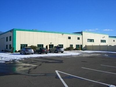
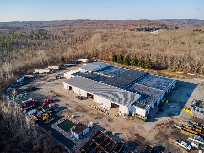
Property Record
40 High Bridge Rd, Sandy Hook, CT 06482

Current Lease Availabilities
Property Detail
40 High Bridge Rd
NEWT-000048-000001-000003
Western Ct
Industrialgeneral
Connecticut
M-1
3
B and X Area of moderate flood hazard, usually the area between the limits of the 100-year and 500-year floods.
6 AC
2025
Newtown
2025
Westchester/So Connecticut
230501
Bridgeport-Stamford-Danbury, CT
58,718 SF
NEARBY LISTINGS FOR SALE OR LEASE
DEMOGRAPHICS near 40 High Bridge Rd
1 mile
3 mile
5 mile
2025 Total Population
1,137
17,017
45,938
2030 Population
1,169
17,452
47,265
Pop Growth 2025-2030
+ 2.81%
+ 2.56%
+ 2.89%
Average Age
43
43
43
2025 Total Households
354
5,921
16,235
HH Growth 2025-2030
+ 2.82%
+ 2.55%
+ 2.90%
Median Household Inc
$168,421
$146,572
$153,999
Avg Household Size
2.90
2.70
2.80
2025 Avg HH Vehicles
2.00
2.00
2.00
Median Home Value
$592,500
$496,935
$520,427
Median Year Built
1988
1979
1977
Nearby Places
Map Layers
Map Styles
 Street
 Aerial
Transit
 Traffic
 Biking
Places
Listings with unknown addresses are not visible on the map
- Restaurants
- Banks
- Shops
- Fitness
- Groceries
PUBLIC TRANSPORTATION
AIRPORT
Tweed/New Haven
Drive
Walk
Distance
Tweed/New Haven
45 min
25.3 mi
Freight Ports
Port of New Haven
Drive
Walk
Distance
Port of New Haven
40 min
22.4 mi
Nearby Properties
Address
Land Use
TOTAL SIZE
Lot Size
Zoning
Address
Land Use
TOTAL SIZE
Lot Size
Zoning
114.88 AC
CA
Address
Land Use
TOTAL SIZE
Lot Size
Zoning
260,491 SF
42.60 AC
RF2
Address
Land Use
TOTAL SIZE
Lot Size
Zoning
71.97 AC
RF2
Address
Land Use
TOTAL SIZE
Lot Size
Zoning
167,124 SF
37.33 AC
M-1
Address
Land Use
TOTAL SIZE
Lot Size
Zoning
43.38 AC
EH-10
Address
Land Use
TOTAL SIZE
Lot Size
Zoning
13,922 SF
62.75 AC
EH-10
Address
Land Use
TOTAL SIZE
Lot Size
Zoning
19.16 AC
R-2
Address
Land Use
TOTAL SIZE
Lot Size
Zoning
23.95 AC
M-1
Address
Land Use
TOTAL SIZE
Lot Size
Zoning
252,800 SF
22.70 AC
M-1
Address
Land Use
TOTAL SIZE
Lot Size
Zoning
12,074 SF
22.73 AC
SDD1
Address
Land Use
TOTAL SIZE
Lot Size
Zoning
30,220 SF
5.48 AC
M-4
Address
Land Use
TOTAL SIZE
Lot Size
Zoning
13.98 AC
M-4
Address
Land Use
TOTAL SIZE
Lot Size
Zoning
85,649 SF
16.15 AC
I2
Address
Land Use
TOTAL SIZE
Lot Size
Zoning
7.52 AC
M-1
Address
Land Use
TOTAL SIZE
Lot Size
Zoning
114,140 SF
10.35 AC
I3
Address
Land Use
TOTAL SIZE
Lot Size
Zoning
15.72 AC
I2
Address
Land Use
TOTAL SIZE
Lot Size
Zoning
41,569 SF
7.15 AC
I2
Address
Land Use
TOTAL SIZE
Lot Size
Zoning
40,144 SF
8.69 AC
M-1
Address
Land Use
TOTAL SIZE
Lot Size
Zoning
42,060 SF
16.64 AC
I2
Address
Land Use
TOTAL SIZE
Lot Size
Zoning
7.50 AC
I2
Address
Land Use
TOTAL SIZE
Lot Size
Zoning
141,282 SF
41.59 AC
M-1
Address
Land Use
TOTAL SIZE
Lot Size
Zoning
66,380 SF
8.02 AC
M-4
Address
Land Use
TOTAL SIZE
Lot Size
Zoning
30 AC
M-3
Address
Land Use
TOTAL SIZE
Lot Size
Zoning
128,744 SF
17.68 AC
M-5
Address
Land Use
TOTAL SIZE
Lot Size
Zoning
28,013 SF
10.64 AC
M-1
Address
Land Use
TOTAL SIZE
Lot Size
Zoning
35,860 SF
12.03 AC
I2
Address
Land Use
TOTAL SIZE
Lot Size
Zoning
48,096 SF
4.04 AC
I1 RF1
Address
Land Use
TOTAL SIZE
Lot Size
Zoning
35,000 SF
6.99 AC
I2
Address
Land Use
TOTAL SIZE
Lot Size
Zoning
60,720 SF
10.64 AC
M-1
Address
Land Use
TOTAL SIZE
Lot Size
Zoning
4.48 AC
SDD1
The World's #1 Commercial Real Estate Marketplace
Connect with us
© 2026 CoStar Group
The information above has been obtained from sources believed reliable. While we do not doubt its accuracy we have not verified it and make no guarantee, warranty or representation about it. It is your responsibility to independently confirm its accuracy and completeness. Any projections, opinions, assumptions, or estimates used are for example only and do not represent the current or future performance of the property. The value of this transaction to you depends on tax and other factors which should be evaluated by your tax, financial, and legal advisors. You and your advisors should conduct a careful, independent investigation of the property to determine to your satisfaction the suitability of the property for your needs.