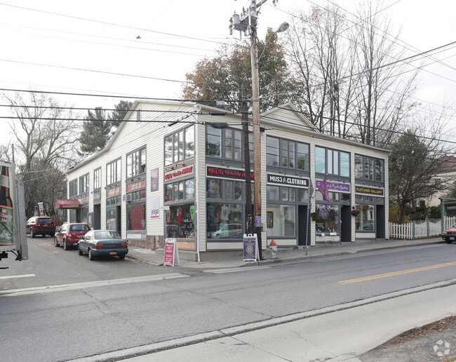
Property Record
40 Mill Hill Rd, Woodstock, NY 12498


NEARBY LISTINGS FOR SALE OR LEASE
Property Detail
40 Mill Hill Rd
5800-027.055-0004-007.000-0000
Ulster
Commercialofficeresidentialmixeduse
New York
X
7.000
36111C0290F
0.28 AC
2025
Hudson Valley Area
2024
Other Market Areas
950500
Kingston, NY
7,486 SF
DEMOGRAPHICS near 40 Mill Hill Rd
1 Mile
3 Mile
5 Mile
2024 Total Population
1,940
7,540
10,932
2029 Population
1,961
7,598
11,008
Pop Growth 2024-2029
+ 1.08%
+ 0.77%
+ 0.70%
Average Age
51
51
50
2024 Total Households
1,027
3,696
5,276
HH Growth 2024-2029
+ 1.07%
+ 0.78%
+ 0.70%
Median Household Inc
$54,142
$74,534
$76,385
Avg Household Size
1.80
2.00
2.00
2024 Avg HH Vehicles
1.00
2.00
2.00
Median Home Value
$613,506
$418,523
$392,878
Median Year Built
1957
1965
1966
Nearby Places
Map Layers
Map Styles
 Street
 Aerial
- Restaurants
- Banks
- Shops
- Fitness
- Groceries
SALE & LEASE HISTORY
LISTING DATE
SALE/LEASE

Nov 16, 2017
For Lease
May 14, 2025
For Lease
May 13, 2025
For Lease
Jun 17, 2021
For Sale
Jul 06, 2021
For Sale
Aug 22, 2022
For Lease
Aug 18, 2021
For Sale
Nearby Properties
Address
Land Use
TOTAL SIZE
Lot Size
Zoning
Address
Land Use
TOTAL SIZE
Lot Size
Zoning
46,888 SF
23.04 AC
R5
Address
Land Use
TOTAL SIZE
Lot Size
Zoning
15,400 SF
7.43 AC
B1
Address
Land Use
TOTAL SIZE
Lot Size
Zoning
19,075 SF
1.74 AC
R1.5
Address
Land Use
TOTAL SIZE
Lot Size
Zoning
60,400 SF
11.50 AC
Address
Land Use
TOTAL SIZE
Lot Size
Zoning
10,878 SF
14.54 AC
NC
Address
Land Use
TOTAL SIZE
Lot Size
Zoning
13,204 SF
2.38 AC
HC
Address
Land Use
TOTAL SIZE
Lot Size
Zoning
14,956 SF
12.70 AC
R1
Address
Land Use
TOTAL SIZE
Lot Size
Zoning
11,032 SF
7.40 AC
A4
Address
Land Use
TOTAL SIZE
Lot Size
Zoning
1,853 SF
153.90 AC
R5
Address
Land Use
TOTAL SIZE
Lot Size
Zoning
10.57 AC
05 - COMME
Address
Land Use
TOTAL SIZE
Lot Size
Zoning
11,365 SF
2.42 AC
HR
Address
Land Use
TOTAL SIZE
Lot Size
Zoning
2,380 SF
27.67 AC
R8
Address
Land Use
TOTAL SIZE
Lot Size
Zoning
14,658 SF
6.96 AC
R3
Address
Land Use
TOTAL SIZE
Lot Size
Zoning
8,846 SF
8.90 AC
R1
Address
Land Use
TOTAL SIZE
Lot Size
Zoning
14,976 SF
4.64 AC
R3
Address
Land Use
TOTAL SIZE
Lot Size
Zoning
43,455 SF
6.15 AC
LI
Address
Land Use
TOTAL SIZE
Lot Size
Zoning
14,584 SF
1.31 AC
HC
Address
Land Use
TOTAL SIZE
Lot Size
Zoning
14,871 SF
1.90 AC
Address
Land Use
TOTAL SIZE
Lot Size
Zoning
3,117 SF
7.62 AC
R3
Address
Land Use
TOTAL SIZE
Lot Size
Zoning
3,572 SF
7.38 AC
R3
Address
Land Use
TOTAL SIZE
Lot Size
Zoning
2,464 SF
7.30 AC
02 - SINGL
Address
Land Use
TOTAL SIZE
Lot Size
Zoning
60,301 SF
27.63 AC
R1.5
Address
Land Use
TOTAL SIZE
Lot Size
Zoning
2,488 SF
3.60 AC
R1
Address
Land Use
TOTAL SIZE
Lot Size
Zoning
12,895 SF
1.48 AC
LI
Address
Land Use
TOTAL SIZE
Lot Size
Zoning
8,732 SF
3.16 AC
R1.5
Address
Land Use
TOTAL SIZE
Lot Size
Zoning
7,692 SF
6.46 AC
R1
Address
Land Use
TOTAL SIZE
Lot Size
Zoning
9,076 SF
5.60 AC
R1
Address
Land Use
TOTAL SIZE
Lot Size
Zoning
4,874 SF
5.68 AC
R5
Address
Land Use
TOTAL SIZE
Lot Size
Zoning
3,968 SF
3.17 AC
R3
Address
Land Use
TOTAL SIZE
Lot Size
Zoning
2,727 SF
3.90 AC
R1
The World's #1 Commercial Real Estate Marketplace
Connect with us
© 2026 CoStar Group
The information above has been obtained from sources believed reliable. While we do not doubt its accuracy we have not verified it and make no guarantee, warranty or representation about it. It is your responsibility to independently confirm its accuracy and completeness. Any projections, opinions, assumptions, or estimates used are for example only and do not represent the current or future performance of the property. The value of this transaction to you depends on tax and other factors which should be evaluated by your tax, financial, and legal advisors. You and your advisors should conduct a careful, independent investigation of the property to determine to your satisfaction the suitability of the property for your needs.