Property Record
40 N Main St, Honea Path, SC 29654
Save to a Folder
{{folder.Name}}
{{folder.ListingIds.length}} Properties
{{folder.ListingIds.length}} Property
Create a New Folder
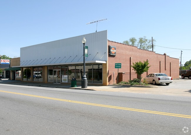
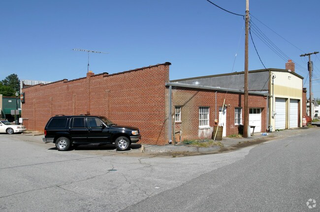
Property Detail
40 N Main St
275-07-03-004
CP 000/00000 D 00247F 00163 PP 000/00000 PARK RD
Storebuilding
Anderson
B and X Area of moderate flood hazard, usually the area between the limits of the 100-year and 500-year floods.
South Carolina
2025
0.15 AC
2025
Anderson Cy S of I-85
011401
Greenville/Spartanburg
5,889 SF
Greenville-Anderson-Greer, SC
NEARBY LISTINGS FOR SALE OR LEASE
-
-
View all Honea Path listings for sale on LoopNet.com
DEMOGRAPHICS near 40 N Main St
1 mile
3 mile
5 mile
2025 Total Population
3,674
5,903
8,886
2030 Population
3,846
6,158
9,250
Pop Growth 2025-2030
+ 4.68%
+ 4.32%
+ 4.10%
Average Age
40
41
41
2025 Total Households
1,483
2,389
3,579
HH Growth 2025-2030
+ 4.86%
+ 4.48%
+ 4.25%
Median Household Inc
$60,643
$59,733
$60,937
Avg Household Size
2.50
2.50
2.50
2025 Avg HH Vehicles
2.00
2.00
2.00
Median Home Value
$155,135
$161,170
$170,023
Median Year Built
1972
1974
1977
Nearby Places
Map Layers
Map Styles
 Street
 Aerial
Layers
 Traffic
 Biking
Places
Listings with unknown addresses are not visible on the map
- Restaurants
- Banks
- Shops
- Fitness
- Groceries
Nearby Properties
Address
Land Use
TOTAL SIZE
Lot Size
Zoning
Address
Land Use
TOTAL SIZE
Lot Size
Zoning
1,782 SF
22.28 AC
Address
Land Use
TOTAL SIZE
Lot Size
Zoning
60,901 SF
6.44 AC
Address
Land Use
TOTAL SIZE
Lot Size
Zoning
65.73 AC
Address
Land Use
TOTAL SIZE
Lot Size
Zoning
13,805 SF
1.85 AC
Address
Land Use
TOTAL SIZE
Lot Size
Zoning
7,296 SF
1.41 AC
Address
Land Use
TOTAL SIZE
Lot Size
Zoning
29,165 SF
3.38 AC
Address
Land Use
TOTAL SIZE
Lot Size
Zoning
2,289 SF
6.09 AC
Address
Land Use
TOTAL SIZE
Lot Size
Zoning
1,907 SF
2.84 AC
Address
Land Use
TOTAL SIZE
Lot Size
Zoning
7,859 SF
4.03 AC
Address
Land Use
TOTAL SIZE
Lot Size
Zoning
9,966 SF
1.64 AC
Address
Land Use
TOTAL SIZE
Lot Size
Zoning
1,084 SF
2.40 AC
Address
Land Use
TOTAL SIZE
Lot Size
Zoning
1,432 SF
2.96 AC
Address
Land Use
TOTAL SIZE
Lot Size
Zoning
13,079 SF
3 AC
Address
Land Use
TOTAL SIZE
Lot Size
Zoning
3,194 SF
0.93 AC
Address
Land Use
TOTAL SIZE
Lot Size
Zoning
1,611 SF
1.48 AC
Address
Land Use
TOTAL SIZE
Lot Size
Zoning
3,158 SF
1.30 AC
Address
Land Use
TOTAL SIZE
Lot Size
Zoning
2,396 SF
1.83 AC
Address
Land Use
TOTAL SIZE
Lot Size
Zoning
2,356 SF
Address
Land Use
TOTAL SIZE
Lot Size
Zoning
1,056 SF
3 AC
Address
Land Use
TOTAL SIZE
Lot Size
Zoning
4.20 AC
Address
Land Use
TOTAL SIZE
Lot Size
Zoning
4,850 SF
1 AC
Address
Land Use
TOTAL SIZE
Lot Size
Zoning
887 SF
3.06 AC
Address
Land Use
TOTAL SIZE
Lot Size
Zoning
2,999 SF
1.89 AC
Address
Land Use
TOTAL SIZE
Lot Size
Zoning
1,715 SF
Address
Land Use
TOTAL SIZE
Lot Size
Zoning
122,670 SF
10.94 AC
Address
Land Use
TOTAL SIZE
Lot Size
Zoning
12.08 AC
Address
Land Use
TOTAL SIZE
Lot Size
Zoning
6,222 SF
1.39 AC
Address
Land Use
TOTAL SIZE
Lot Size
Zoning
21,600 SF
4 AC
Address
Land Use
TOTAL SIZE
Lot Size
Zoning
The World's #1 Commercial Real Estate Marketplace
Connect with us
© 2026 CoStar Group
The information above has been obtained from sources believed reliable. While we do not doubt its accuracy we have not verified it and make no guarantee, warranty or representation about it. It is your responsibility to independently confirm its accuracy and completeness. Any projections, opinions, assumptions, or estimates used are for example only and do not represent the current or future performance of the property. The value of this transaction to you depends on tax and other factors which should be evaluated by your tax, financial, and legal advisors. You and your advisors should conduct a careful, independent investigation of the property to determine to your satisfaction the suitability of the property for your needs.