Property Record
40 N Main St, Springboro, OH 45066
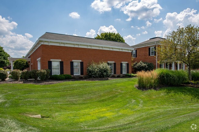

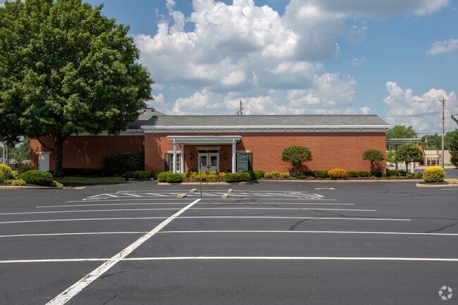
Property Detail
40 N Main St
04-07-102-098
MAIN
Funeralhome
Warren
B and X Area of moderate flood hazard, usually the area between the limits of the 100-year and 500-year floods.
Ohio
2024
0.78 AC
2025
Outlying Warren County
030504
Cincinnati/Dayton
9,222 SF
Cincinnati, OH-KY-IN
NEARBY LISTINGS FOR SALE OR LEASE
DEMOGRAPHICS near 40 N Main St
1 mile
3 mile
5 mile
2025 Total Population
6,757
37,927
89,028
2030 Population
6,960
39,346
91,428
Pop Growth 2025-2030
+ 3.00%
+ 3.74%
+ 2.70%
Average Age
41
41
40
2025 Total Households
2,564
13,913
34,554
HH Growth 2025-2030
+ 3.08%
+ 3.78%
+ 2.49%
Median Household Inc
$110,288
$111,390
$101,333
Avg Household Size
2.60
2.70
2.50
2025 Avg HH Vehicles
2.00
2.00
2.00
Median Home Value
$310,470
$362,083
$340,487
Median Year Built
1980
1994
1992
Nearby Places
Map Layers
Map Styles
 Street
 Aerial
Layers
 Traffic
 Biking
Places
Listings with unknown addresses are not visible on the map
- Restaurants
- Banks
- Shops
- Fitness
- Groceries
PUBLIC TRANSPORTATION
AIRPORT
James M Cox Dayton International
Drive
Walk
Distance
James M Cox Dayton International
40 min
27.8 mi
Nearby Properties
Address
Land Use
TOTAL SIZE
Lot Size
Zoning
Address
Land Use
TOTAL SIZE
Lot Size
Zoning
2,908 SF
16.01 AC
Address
Land Use
TOTAL SIZE
Lot Size
Zoning
142,758 SF
11.15 AC
Address
Land Use
TOTAL SIZE
Lot Size
Zoning
6,048 SF
51.16 AC
Address
Land Use
TOTAL SIZE
Lot Size
Zoning
507,846 SF
23.90 AC
Address
Land Use
TOTAL SIZE
Lot Size
Zoning
39,404 SF
55.59 AC
Address
Land Use
TOTAL SIZE
Lot Size
Zoning
36,570 SF
20.29 AC
Address
Land Use
TOTAL SIZE
Lot Size
Zoning
64,121 SF
21.21 AC
Address
Land Use
TOTAL SIZE
Lot Size
Zoning
16.05 AC
Address
Land Use
TOTAL SIZE
Lot Size
Zoning
56.81 AC
R1
Address
Land Use
TOTAL SIZE
Lot Size
Zoning
4,578 SF
10.81 AC
Address
Land Use
TOTAL SIZE
Lot Size
Zoning
20,093 SF
11.15 AC
Address
Land Use
TOTAL SIZE
Lot Size
Zoning
139,382 SF
40.01 AC
Address
Land Use
TOTAL SIZE
Lot Size
Zoning
11,260 SF
6.32 AC
Address
Land Use
TOTAL SIZE
Lot Size
Zoning
122,344 SF
2.17 AC
Address
Land Use
TOTAL SIZE
Lot Size
Zoning
48,378 SF
63.28 AC
Address
Land Use
TOTAL SIZE
Lot Size
Zoning
41,424 SF
50.03 AC
Address
Land Use
TOTAL SIZE
Lot Size
Zoning
55,611 SF
9.56 AC
Address
Land Use
TOTAL SIZE
Lot Size
Zoning
66,650 SF
14.98 AC
Address
Land Use
TOTAL SIZE
Lot Size
Zoning
11,847 SF
5.96 AC
Address
Land Use
TOTAL SIZE
Lot Size
Zoning
70,217 SF
12.25 AC
Address
Land Use
TOTAL SIZE
Lot Size
Zoning
32,550 SF
26.11 AC
Address
Land Use
TOTAL SIZE
Lot Size
Zoning
1,848 SF
50.22 AC
Address
Land Use
TOTAL SIZE
Lot Size
Zoning
487,924 SF
22.33 AC
Address
Land Use
TOTAL SIZE
Lot Size
Zoning
85,514 SF
3.20 AC
Address
Land Use
TOTAL SIZE
Lot Size
Zoning
217,679 SF
25.16 AC
Address
Land Use
TOTAL SIZE
Lot Size
Zoning
26,459 SF
6.95 AC
Address
Land Use
TOTAL SIZE
Lot Size
Zoning
80,388 SF
2.36 AC
Address
Land Use
TOTAL SIZE
Lot Size
Zoning
13.19 AC
Address
Land Use
TOTAL SIZE
Lot Size
Zoning
78.15 AC
Address
Land Use
TOTAL SIZE
Lot Size
Zoning
63,278 SF
10 AC
The World's #1 Commercial Real Estate Marketplace
Connect with us
© 2026 CoStar Group
The information above has been obtained from sources believed reliable. While we do not doubt its accuracy we have not verified it and make no guarantee, warranty or representation about it. It is your responsibility to independently confirm its accuracy and completeness. Any projections, opinions, assumptions, or estimates used are for example only and do not represent the current or future performance of the property. The value of this transaction to you depends on tax and other factors which should be evaluated by your tax, financial, and legal advisors. You and your advisors should conduct a careful, independent investigation of the property to determine to your satisfaction the suitability of the property for your needs.