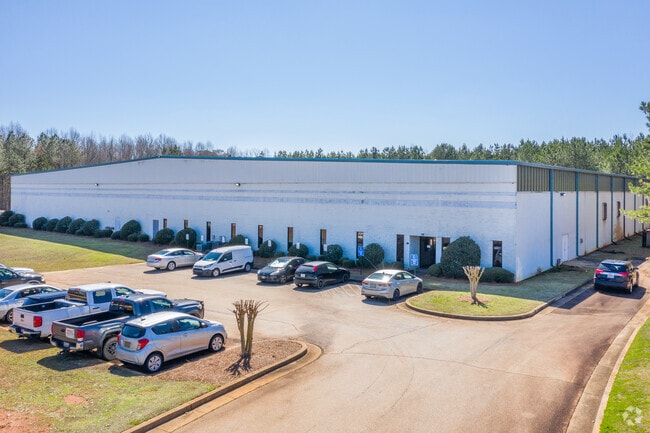
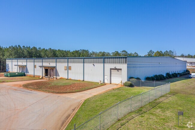
Property Record
40 Pinyon Rd, Covington, GA 30016

Property Detail
40 Pinyon Rd
0024000000192000
10.71AC LOT D PINYON RD
Warehouse
Newton
I1
Georgia
A Areas with a 1% annual chance of flooding and a 26% chance of flooding over the life of a 30-year mortgage.
d
2025
10.71 AC
2025
Rockdale/Newton Cnty
100505
Atlanta
60,000 SF
Atlanta-Sandy Springs-Roswell, GA
NEARBY LISTINGS FOR SALE OR LEASE
DEMOGRAPHICS near 40 Pinyon Rd
1 mile
3 mile
5 mile
2025 Total Population
4,109
36,446
96,190
2030 Population
4,435
39,196
103,042
Pop Growth 2025-2030
+ 7.93%
+ 7.55%
+ 7.12%
Average Age
38
37
38
2025 Total Households
1,396
12,765
33,798
HH Growth 2025-2030
+ 8.09%
+ 7.66%
+ 7.28%
Median Household Inc
$110,548
$73,768
$73,857
Avg Household Size
2.90
2.80
2.80
2025 Avg HH Vehicles
3.00
2.00
2.00
Median Home Value
$314,927
$286,052
$277,450
Median Year Built
1999
1999
1996
Nearby Places
Map Layers
Map Styles
 Street
 Aerial
Transit
 Traffic
 Biking
Places
Listings with unknown addresses are not visible on the map
- Restaurants
- Banks
- Shops
- Fitness
- Groceries
PUBLIC TRANSPORTATION
AIRPORT
Hartsfield - Jackson Atlanta International
Drive
Walk
Distance
Hartsfield - Jackson Atlanta International
50 min
33.9 mi
SALE & LEASE HISTORY
LISTING DATE
SALE/LEASE

May 17, 2018
For Lease
Jun 26, 2019
For Lease
Jul 25, 2018
For Sale
Nearby Properties
Address
Land Use
TOTAL SIZE
Lot Size
Zoning
Address
Land Use
TOTAL SIZE
Lot Size
Zoning
4,734 SF
35.19 AC
RMF
Address
Land Use
TOTAL SIZE
Lot Size
Zoning
4,162 SF
37.52 AC
R3
Address
Land Use
TOTAL SIZE
Lot Size
Zoning
306,886 SF
118.50 AC
R2
Address
Land Use
TOTAL SIZE
Lot Size
Zoning
1,648 SF
25.08 AC
C1
Address
Land Use
TOTAL SIZE
Lot Size
Zoning
882,960 SF
0.01 AC
Address
Land Use
TOTAL SIZE
Lot Size
Zoning
324,975 SF
35.98 AC
M1
Address
Land Use
TOTAL SIZE
Lot Size
Zoning
135,000 SF
24.77 AC
M1
Address
Land Use
TOTAL SIZE
Lot Size
Zoning
33,216 SF
8.26 AC
MXD/CID/MU
Address
Land Use
TOTAL SIZE
Lot Size
Zoning
17,056 SF
16.78 AC
C1
Address
Land Use
TOTAL SIZE
Lot Size
Zoning
177,123 SF
9.63 AC
MXD/CID/MU
Address
Land Use
TOTAL SIZE
Lot Size
Zoning
5,902 SF
903.52 AC
RES AG
Address
Land Use
TOTAL SIZE
Lot Size
Zoning
131,111 SF
22.17 AC
R3
Address
Land Use
TOTAL SIZE
Lot Size
Zoning
372,762 SF
32.27 AC
A1
Address
Land Use
TOTAL SIZE
Lot Size
Zoning
163,807 SF
10.60 AC
M1
Address
Land Use
TOTAL SIZE
Lot Size
Zoning
5,160 SF
45.17 AC
C1
Address
Land Use
TOTAL SIZE
Lot Size
Zoning
882,960 SF
114.02 AC
M1
Address
Land Use
TOTAL SIZE
Lot Size
Zoning
154,980 SF
17.37 AC
M1
Address
Land Use
TOTAL SIZE
Lot Size
Zoning
8,156 SF
14.49 AC
C1
Address
Land Use
TOTAL SIZE
Lot Size
Zoning
8,832 SF
8.26 AC
C1
Address
Land Use
TOTAL SIZE
Lot Size
Zoning
8,632 SF
8.11 AC
C1
Address
Land Use
TOTAL SIZE
Lot Size
Zoning
42,540 SF
2.40 AC
MXD
Address
Land Use
TOTAL SIZE
Lot Size
Zoning
77,016 SF
15.28 AC
C2
Address
Land Use
TOTAL SIZE
Lot Size
Zoning
115,823 SF
14.20 AC
M1
Address
Land Use
TOTAL SIZE
Lot Size
Zoning
125,971 SF
23.84 AC
C1
Address
Land Use
TOTAL SIZE
Lot Size
Zoning
65,520 SF
35 AC
E6
Address
Land Use
TOTAL SIZE
Lot Size
Zoning
65,008 SF
23.81 AC
R2
Address
Land Use
TOTAL SIZE
Lot Size
Zoning
19,197 SF
9.72 AC
R3
Address
Land Use
TOTAL SIZE
Lot Size
Zoning
4,768 SF
263.26 AC
C1
Address
Land Use
TOTAL SIZE
Lot Size
Zoning
154,336 SF
19.77 AC
M1
Address
Land Use
TOTAL SIZE
Lot Size
Zoning
46,536 SF
3.49 AC
MXD/CID/MU
The World's #1 Commercial Real Estate Marketplace
Connect with us
© 2026 CoStar Group
The information above has been obtained from sources believed reliable. While we do not doubt its accuracy we have not verified it and make no guarantee, warranty or representation about it. It is your responsibility to independently confirm its accuracy and completeness. Any projections, opinions, assumptions, or estimates used are for example only and do not represent the current or future performance of the property. The value of this transaction to you depends on tax and other factors which should be evaluated by your tax, financial, and legal advisors. You and your advisors should conduct a careful, independent investigation of the property to determine to your satisfaction the suitability of the property for your needs.