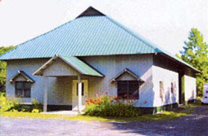
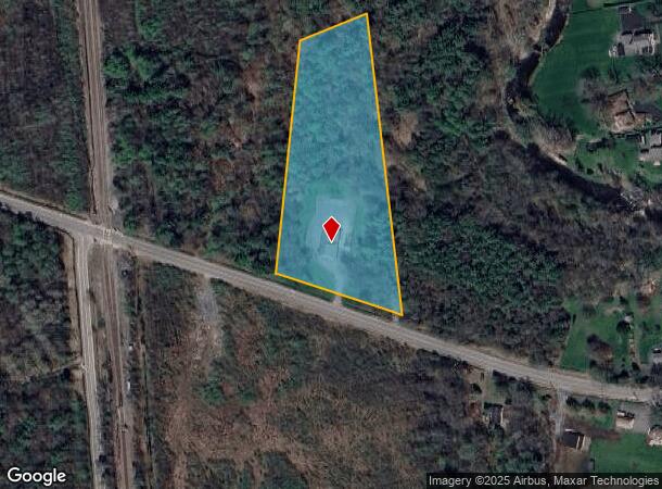
Property Record
40 S Junction Rd, Plattsburgh, NY 12901
NEARBY LISTINGS FOR SALE OR LEASE
Property Detail
40 S Junction Rd
094200-246-000-0001-013-002-0000
BOOTH SUB LOT 2
Storesoffices
Clinton
X
New York
36019C0614E
13.002
2025
3.61 AC
2024
Upstate New York Area
102100
Other Market Areas
3,498 SF
Plattsburgh, NY
DEMOGRAPHICS near 40 S Junction Rd
1 Mile
3 Mile
5 Mile
2024 Total Population
291
3,371
19,828
2029 Population
292
3,357
19,689
Pop Growth 2024-2029
+ 0.34%
(0.42%)
(0.70%)
Average Age
44
43
42
2024 Total Households
124
1,408
9,131
HH Growth 2024-2029
+ 0.81%
(0.36%)
(0.74%)
Median Household Inc
$68,181
$73,676
$54,126
Avg Household Size
2.40
2.40
2.10
2024 Avg HH Vehicles
2.00
2.00
1.00
Median Home Value
$247,500
$163,182
$151,876
Median Year Built
1973
1977
1971
Nearby Places
- Restaurants
- Banks
- Shops
- Fitness
- Groceries
PUBLIC TRANSPORTATION
COMMUTER RAIL
Plattsburgh Amtrak Station (Adirondack - Amtrak)
DRIVE
WALK
Distance
Plattsburgh Amtrak Station (Adirondack - Amtrak)
9 min
5.5 mi
AIRPORT
Plattsburgh International
DRIVE
WALK
Distance
Plattsburgh International
8 min
4.2 mi
Patrick Leahy Burlington International
DRIVE
WALK
Distance
Patrick Leahy Burlington International
75 min
36.3 mi
Freight Ports
Montreal
DRIVE
WALK
Distance
Montreal
95 min
70.7 mi
Nearby Properties
Address
Land Use
TOTAL SIZE
Lot Size
Zoning
Address
Land Use
TOTAL SIZE
Lot Size
Zoning
800 SF
776.23 AC
A1
Address
Land Use
TOTAL SIZE
Lot Size
Zoning
121,465 SF
92 AC
R-2
Address
Land Use
TOTAL SIZE
Lot Size
Zoning
564.20 AC
A1
Address
Land Use
TOTAL SIZE
Lot Size
Zoning
114,712 SF
9.72 AC
A2
Address
Land Use
TOTAL SIZE
Lot Size
Zoning
160.68 AC
LC_OS
Address
Land Use
TOTAL SIZE
Lot Size
Zoning
40,926 SF
27.50 AC
C
Address
Land Use
TOTAL SIZE
Lot Size
Zoning
60,693 SF
9.40 AC
A1
Address
Land Use
TOTAL SIZE
Lot Size
Zoning
101,505 SF
6.16 AC
A2
Address
Land Use
TOTAL SIZE
Lot Size
Zoning
67,573 SF
24.31 AC
NC
Address
Land Use
TOTAL SIZE
Lot Size
Zoning
80,936 SF
89.34 AC
A1
Address
Land Use
TOTAL SIZE
Lot Size
Zoning
26,964 SF
3.03 AC
I
Address
Land Use
TOTAL SIZE
Lot Size
Zoning
76,516 SF
4.49 AC
A2
Address
Land Use
TOTAL SIZE
Lot Size
Zoning
10,726 SF
8.46 AC
MDR
Address
Land Use
TOTAL SIZE
Lot Size
Zoning
51,594 SF
6.35 AC
A2
Address
Land Use
TOTAL SIZE
Lot Size
Zoning
26,500 SF
14.55 AC
A2
Address
Land Use
TOTAL SIZE
Lot Size
Zoning
3,131 SF
136.11 AC
R-2
Address
Land Use
TOTAL SIZE
Lot Size
Zoning
21,456 SF
16.05 AC
NC
Address
Land Use
TOTAL SIZE
Lot Size
Zoning
65,045 SF
5.89 AC
A2
Address
Land Use
TOTAL SIZE
Lot Size
Zoning
6,000 SF
12.67 AC
SC
Address
Land Use
TOTAL SIZE
Lot Size
Zoning
50,400 SF
4.52 AC
A2
Address
Land Use
TOTAL SIZE
Lot Size
Zoning
31,451 SF
8.07 AC
NC
Address
Land Use
TOTAL SIZE
Lot Size
Zoning
2,081 SF
13.08 AC
R-2
Address
Land Use
TOTAL SIZE
Lot Size
Zoning
16,289 SF
6.53 AC
NC
Address
Land Use
TOTAL SIZE
Lot Size
Zoning
1,216 SF
54.89 AC
Address
Land Use
TOTAL SIZE
Lot Size
Zoning
43,213 SF
7.62 AC
A2
Address
Land Use
TOTAL SIZE
Lot Size
Zoning
Address
Land Use
TOTAL SIZE
Lot Size
Zoning
4,338 SF
7.80 AC
Address
Land Use
TOTAL SIZE
Lot Size
Zoning
4,459 SF
1.28 AC
C
Address
Land Use
TOTAL SIZE
Lot Size
Zoning
7,089 SF
8.10 AC
Address
Land Use
TOTAL SIZE
Lot Size
Zoning
17,440 SF
8 AC
SC
The World's #1 Commercial Real Estate Marketplace
Connect with us
© 2025 CoStar Group
The information above has been obtained from sources believed reliable. While we do not doubt its accuracy we have not verified it and make no guarantee, warranty or representation about it. It is your responsibility to independently confirm its accuracy and completeness. Any projections, opinions, assumptions, or estimates used are for example only and do not represent the current or future performance of the property. The value of this transaction to you depends on tax and other factors which should be evaluated by your tax, financial, and legal advisors. You and your advisors should conduct a careful, independent investigation of the property to determine to your satisfaction the suitability of the property for your needs.