Property Record
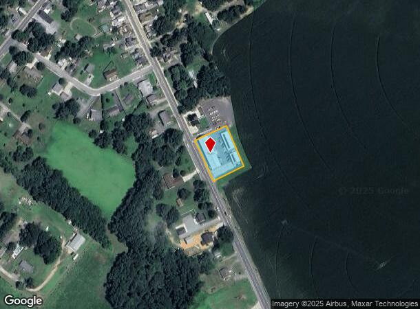
40 N Main St, Magnolia, DE 19962

NEARBY LISTINGS FOR SALE OR LEASE
Property Detail
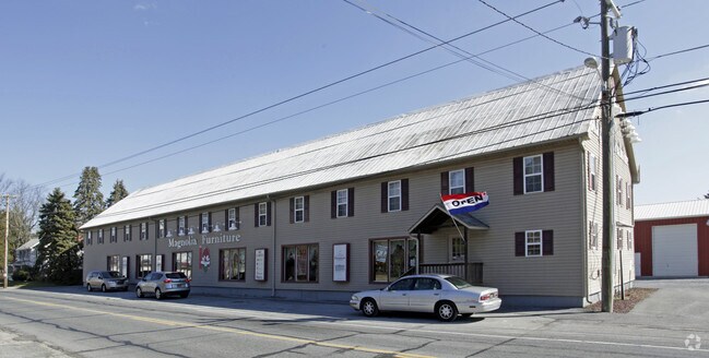
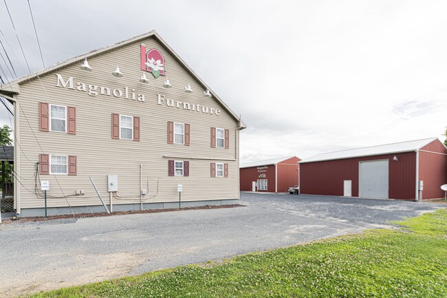
40 N Main St
8-15-11310-01-1700-000
East Side Of Main Street
Commercialnec
E. SD. MAIN ST., MAGNOLIA, 0.674 A. W/LARGE FRAME BLDG.
X
Kent
10001C0253J
Delaware
2025
0.68 AC
2025
Kent County
042207
Philadelphia
12,000 SF
Dover, DE
DEMOGRAPHICS near 40 N Main St
1 Mile
3 Mile
5 Mile
2024 Total Population
1,295
15,082
43,173
2029 Population
1,371
16,076
46,249
Pop Growth 2024-2029
+ 5.87%
+ 6.59%
+ 7.12%
Average Age
40
40
39
2024 Total Households
461
5,378
15,814
HH Growth 2024-2029
+ 6.29%
+ 6.92%
+ 7.41%
Median Household Inc
$91,517
$87,445
$75,130
Avg Household Size
2.80
2.80
2.70
2024 Avg HH Vehicles
2.00
2.00
2.00
Median Home Value
$287,650
$322,742
$301,323
Median Year Built
1988
2001
1996
Nearby Places
Map Layers
Map Styles
 Street
 Aerial
- Restaurants
- Banks
- Shops
- Fitness
- Groceries
SALE & LEASE HISTORY
LISTING DATE
SALE/LEASE

Sep 24, 2016
For Sale
Nov 29, 2016
For Sale
Jul 03, 2019
For Sale
Apr 18, 2018
For Sale
Nearby Properties
Address
Land Use
TOTAL SIZE
Lot Size
Zoning
Address
Land Use
TOTAL SIZE
Lot Size
Zoning
990 AC
AC
Address
Land Use
TOTAL SIZE
Lot Size
Zoning
62,728 SF
25 AC
AC
Address
Land Use
TOTAL SIZE
Lot Size
Zoning
2,768 SF
335.80 AC
AC
Address
Land Use
TOTAL SIZE
Lot Size
Zoning
64,067 SF
33.61 AC
AC
Address
Land Use
TOTAL SIZE
Lot Size
Zoning
1,175 SF
53.20 AC
RMH
Address
Land Use
TOTAL SIZE
Lot Size
Zoning
323.98 AC
AP/10
Address
Land Use
TOTAL SIZE
Lot Size
Zoning
1,792 SF
27.10 AC
RMH
Address
Land Use
TOTAL SIZE
Lot Size
Zoning
33,674 SF
20 AC
AC
Address
Land Use
TOTAL SIZE
Lot Size
Zoning
343.80 AC
AC
Address
Land Use
TOTAL SIZE
Lot Size
Zoning
21,864 SF
233.90 AC
AC
Address
Land Use
TOTAL SIZE
Lot Size
Zoning
60,679 SF
8.13 AC
NA
Address
Land Use
TOTAL SIZE
Lot Size
Zoning
1,399 SF
21.60 AC
RMH
Address
Land Use
TOTAL SIZE
Lot Size
Zoning
37,980 SF
4.30 AC
BN
Address
Land Use
TOTAL SIZE
Lot Size
Zoning
9,384 SF
40.17 AC
AC
Address
Land Use
TOTAL SIZE
Lot Size
Zoning
17.50 AC
RMH
Address
Land Use
TOTAL SIZE
Lot Size
Zoning
14,040 SF
4.90 AC
BN
Address
Land Use
TOTAL SIZE
Lot Size
Zoning
2,922 SF
28.80 AC
AC
Address
Land Use
TOTAL SIZE
Lot Size
Zoning
7,366 SF
87.50 AC
AC
Address
Land Use
TOTAL SIZE
Lot Size
Zoning
1,026 SF
23.12 AC
RMH
Address
Land Use
TOTAL SIZE
Lot Size
Zoning
95.40 AC
AC
Address
Land Use
TOTAL SIZE
Lot Size
Zoning
16.10 AC
RMH
Address
Land Use
TOTAL SIZE
Lot Size
Zoning
48 AC
AC
Address
Land Use
TOTAL SIZE
Lot Size
Zoning
13.50 AC
MULTI
Address
Land Use
TOTAL SIZE
Lot Size
Zoning
206 AC
MULTI
Address
Land Use
TOTAL SIZE
Lot Size
Zoning
1,495 SF
20.18 AC
RMH
Address
Land Use
TOTAL SIZE
Lot Size
Zoning
7.20 AC
RMH
Address
Land Use
TOTAL SIZE
Lot Size
Zoning
217.90 AC
AC
Address
Land Use
TOTAL SIZE
Lot Size
Zoning
17,508 SF
1.40 AC
NA
Address
Land Use
TOTAL SIZE
Lot Size
Zoning
2,300 SF
9 AC
RMH
The World's #1 Commercial Real Estate Marketplace
Connect with us
© 2025 CoStar Group
The information above has been obtained from sources believed reliable. While we do not doubt its accuracy we have not verified it and make no guarantee, warranty or representation about it. It is your responsibility to independently confirm its accuracy and completeness. Any projections, opinions, assumptions, or estimates used are for example only and do not represent the current or future performance of the property. The value of this transaction to you depends on tax and other factors which should be evaluated by your tax, financial, and legal advisors. You and your advisors should conduct a careful, independent investigation of the property to determine to your satisfaction the suitability of the property for your needs.