Property Record
40 S Stephanie St, Henderson, NV 89012

Save to a Folder
{{folder.Name}}
{{folder.ListingIds.length}} Properties
{{folder.ListingIds.length}} Property
Create a New Folder
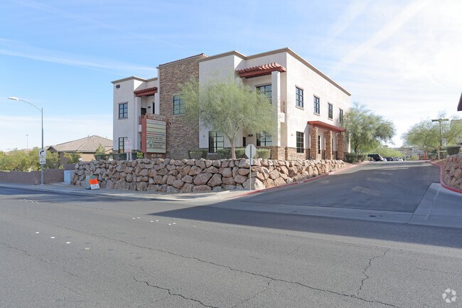
Property Detail
40 S Stephanie St
Las Vegas-Henderson-North Las Vegas, NV
STEPHANIE PASEO VERDE NORTHEAST A 1 LOT COML SUB PLAT BOOK 137 PAGE 55 PT LOT 1 (AIR PARCEL BLDG 5 1ST FLR 5789 SQFT)
178-22-118-008
CLARK
Commercialnec
Nevada
B and X Area of moderate flood hazard, usually the area between the limits of the 100-year and 500-year floods.
1
2026
0.13 AC
2026
South Las Vegas
005353
Las Vegas
5,660 SF
NEARBY LISTINGS FOR SALE OR LEASE
DEMOGRAPHICS near 40 S Stephanie St
1 mile
3 mile
5 mile
2025 Total Population
20,902
109,804
308,081
2030 Population
22,070
115,271
323,697
Pop Growth 2025-2030
+ 5.59%
+ 4.98%
+ 5.07%
Average Age
40
42
41
2025 Total Households
8,869
45,021
122,135
HH Growth 2025-2030
+ 5.64%
+ 5.01%
+ 5.10%
Median Household Inc
$90,601
$92,355
$86,675
Avg Household Size
2.30
2.40
2.50
2025 Avg HH Vehicles
2.00
2.00
2.00
Median Home Value
$490,274
$484,601
$471,177
Median Year Built
2003
1996
1997
Nearby Places
Map Layers
Map Styles
 Street
 Aerial
Layers
 Traffic
 Biking
Places
Listings with unknown addresses are not visible on the map
- Restaurants
- Banks
- Shops
- Fitness
- Groceries
PUBLIC TRANSPORTATION
AIRPORT
Harry Reid International
Drive
Walk
Distance
Harry Reid International
14 min
9.6 mi
Boulder City Municipal
Drive
Walk
Distance
Boulder City Municipal
21 min
14.2 mi
SALE & LEASE HISTORY
LISTING DATE
SALE/LEASE

Sep 25, 2016
For Lease
Mar 10, 2021
For Lease
Nearby Properties
Address
Land Use
TOTAL SIZE
Lot Size
Zoning
Address
Land Use
TOTAL SIZE
Lot Size
Zoning
630,906 SF
39.87 AC
CT
Address
Land Use
TOTAL SIZE
Lot Size
Zoning
678,168 SF
69.69 AC
Address
Land Use
TOTAL SIZE
Lot Size
Zoning
8,536 SF
24.93 AC
Address
Land Use
TOTAL SIZE
Lot Size
Zoning
62,258 SF
59.95 AC
Address
Land Use
TOTAL SIZE
Lot Size
Zoning
14,840 SF
38.54 AC
CC
Address
Land Use
TOTAL SIZE
Lot Size
Zoning
7,177 SF
15.88 AC
Address
Land Use
TOTAL SIZE
Lot Size
Zoning
502,625 SF
45.92 AC
Address
Land Use
TOTAL SIZE
Lot Size
Zoning
7,825 SF
15.41 AC
Address
Land Use
TOTAL SIZE
Lot Size
Zoning
358,212 SF
9.06 AC
CC
Address
Land Use
TOTAL SIZE
Lot Size
Zoning
5,658 SF
16.18 AC
RH24
Address
Land Use
TOTAL SIZE
Lot Size
Zoning
213,957 SF
19.68 AC
Address
Land Use
TOTAL SIZE
Lot Size
Zoning
1,500 SF
25.08 AC
Address
Land Use
TOTAL SIZE
Lot Size
Zoning
61,157 SF
2.54 AC
Address
Land Use
TOTAL SIZE
Lot Size
Zoning
383,889 SF
31.11 AC
Address
Land Use
TOTAL SIZE
Lot Size
Zoning
59,421 SF
14 AC
Address
Land Use
TOTAL SIZE
Lot Size
Zoning
4,446 SF
15.81 AC
CC
Address
Land Use
TOTAL SIZE
Lot Size
Zoning
314,454 SF
22.94 AC
CC
Address
Land Use
TOTAL SIZE
Lot Size
Zoning
17.18 AC
PS
Address
Land Use
TOTAL SIZE
Lot Size
Zoning
222,167 SF
6.99 AC
Address
Land Use
TOTAL SIZE
Lot Size
Zoning
233,958 SF
12.49 AC
RS2
Address
Land Use
TOTAL SIZE
Lot Size
Zoning
4,578 SF
13.23 AC
H:RH-24-MP
Address
Land Use
TOTAL SIZE
Lot Size
Zoning
4,496 SF
15.59 AC
H:RH-24-MP
Address
Land Use
TOTAL SIZE
Lot Size
Zoning
239,288 SF
14.10 AC
Address
Land Use
TOTAL SIZE
Lot Size
Zoning
250,076 SF
24.61 AC
Address
Land Use
TOTAL SIZE
Lot Size
Zoning
3,126 SF
17.69 AC
RM16
Address
Land Use
TOTAL SIZE
Lot Size
Zoning
4,280 SF
18.25 AC
H:RM-16-MP
Address
Land Use
TOTAL SIZE
Lot Size
Zoning
279,107 SF
22.64 AC
CC
Address
Land Use
TOTAL SIZE
Lot Size
Zoning
237,955 SF
40 AC
IG
Address
Land Use
TOTAL SIZE
Lot Size
Zoning
15.17 AC
PS
Address
Land Use
TOTAL SIZE
Lot Size
Zoning
229,309 SF
4.85 AC
The World's #1 Commercial Real Estate Marketplace
Connect with us
© 2026 CoStar Group
The information above has been obtained from sources believed reliable. While we do not doubt its accuracy we have not verified it and make no guarantee, warranty or representation about it. It is your responsibility to independently confirm its accuracy and completeness. Any projections, opinions, assumptions, or estimates used are for example only and do not represent the current or future performance of the property. The value of this transaction to you depends on tax and other factors which should be evaluated by your tax, financial, and legal advisors. You and your advisors should conduct a careful, independent investigation of the property to determine to your satisfaction the suitability of the property for your needs.