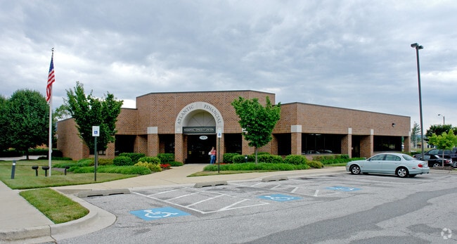
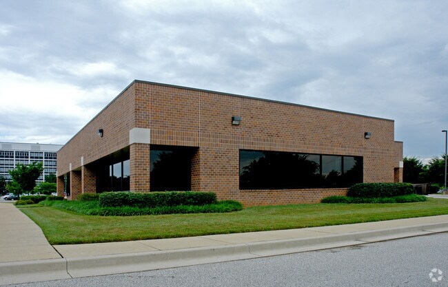
Property Record
40 Schilling Rd, Hunt Valley, MD 21031

NEARBY LISTINGS FOR SALE OR LEASE
Property Detail
40 Schilling Rd
Baltimore-Columbia-Towson, MD
Bell Atlantic
08-2200025171
1.6516 AC BELL ATLANTIC
Financialbuilding
Baltimore
X
Maryland
2400100235G
5
2024
1.65 AC
2025
Route 83 Corridor North
408400
Baltimore
9,320 SF
DEMOGRAPHICS near 40 Schilling Rd
1 mile
3 mile
5 mile
2024 Total Population
3,971
33,460
69,961
2029 Population
3,993
33,078
69,090
Pop Growth 2024-2029
+ 0.55%
(1.14%)
(1.24%)
Average Age
47
42
43
2024 Total Households
1,688
14,695
28,309
HH Growth 2024-2029
+ 0.71%
(1.22%)
(1.29%)
Median Household Inc
$127,542
$88,507
$107,391
Avg Household Size
2.10
2.20
2.40
2024 Avg HH Vehicles
2.00
2.00
2.00
Median Home Value
$425,000
$393,223
$453,893
Median Year Built
2000
1982
1979
Nearby Places
Map Layers
Map Styles
 Street
 Aerial
Transit
 Traffic
 Biking
Places
Listings with unknown addresses are not visible on the map
- Restaurants
- Banks
- Shops
- Fitness
- Groceries
PUBLIC TRANSPORTATION
TRANSIT/SUBWAY
Pepper Road (Hunt Valley & BWI Marshall - Maryland Transit Administration Light Rail (Baltimore Light Rail))
Drive
Walk
Distance
Pepper Road (Hunt Valley & BWI Marshall - Maryland Transit Administration Light Rail (Baltimore Light Rail))
2 min
7 min
0.4 mi
Hunt Valley (Hunt Valley & BWI Marshall - Maryland Transit Administration Light Rail (Baltimore Light Rail))
Drive
Walk
Distance
Hunt Valley (Hunt Valley & BWI Marshall - Maryland Transit Administration Light Rail (Baltimore Light Rail))
3 min
9 min
0.4 mi
Mccormick Road (Hunt Valley & BWI Marshall - Maryland Transit Administration Light Rail (Baltimore Light Rail))
Drive
Walk
Distance
Mccormick Road (Hunt Valley & BWI Marshall - Maryland Transit Administration Light Rail (Baltimore Light Rail))
3 min
12 min
0.6 mi
AIRPORT
Baltimore/Washington International Thurgood Marshall
Drive
Walk
Distance
Baltimore/Washington International Thurgood Marshall
45 min
30.0 mi
Freight Ports
Port of Baltimore
Drive
Walk
Distance
Port of Baltimore
32 min
18.9 mi
Nearby Properties
Address
Land Use
TOTAL SIZE
Lot Size
Zoning
Address
Land Use
TOTAL SIZE
Lot Size
Zoning
513,056 SF
55.49 AC
BM
Address
Land Use
TOTAL SIZE
Lot Size
Zoning
343,606 SF
19.65 AC
Address
Land Use
TOTAL SIZE
Lot Size
Zoning
595,100 SF
5.73 AC
Address
Land Use
TOTAL SIZE
Lot Size
Zoning
38.89 AC
DR16
Address
Land Use
TOTAL SIZE
Lot Size
Zoning
512,317 SF
2.76 AC
BM
Address
Land Use
TOTAL SIZE
Lot Size
Zoning
13,468 SF
32.08 AC
DR16
Address
Land Use
TOTAL SIZE
Lot Size
Zoning
28.74 AC
DR16
Address
Land Use
TOTAL SIZE
Lot Size
Zoning
489,483 SF
84.32 AC
RC4
Address
Land Use
TOTAL SIZE
Lot Size
Zoning
237,800 SF
1.28 AC
BM
Address
Land Use
TOTAL SIZE
Lot Size
Zoning
26.73 AC
DR16
Address
Land Use
TOTAL SIZE
Lot Size
Zoning
250,462 SF
185.60 AC
Address
Land Use
TOTAL SIZE
Lot Size
Zoning
330,802 SF
14.81 AC
ML-IM
Address
Land Use
TOTAL SIZE
Lot Size
Zoning
218,049 SF
22.47 AC
Address
Land Use
TOTAL SIZE
Lot Size
Zoning
176,584 SF
31 AC
Address
Land Use
TOTAL SIZE
Lot Size
Zoning
44.76 AC
DR3.5
Address
Land Use
TOTAL SIZE
Lot Size
Zoning
Address
Land Use
TOTAL SIZE
Lot Size
Zoning
138,000 SF
3.09 AC
Address
Land Use
TOTAL SIZE
Lot Size
Zoning
418,286 SF
22.60 AC
ML
Address
Land Use
TOTAL SIZE
Lot Size
Zoning
172,782 SF
5.35 AC
ML-IM
Address
Land Use
TOTAL SIZE
Lot Size
Zoning
14.49 AC
DR16
Address
Land Use
TOTAL SIZE
Lot Size
Zoning
18.07 AC
DR3.5
Address
Land Use
TOTAL SIZE
Lot Size
Zoning
326,069 SF
9.28 AC
ML-IM
Address
Land Use
TOTAL SIZE
Lot Size
Zoning
204,329 SF
25.45 AC
ML
Address
Land Use
TOTAL SIZE
Lot Size
Zoning
143,260 SF
7.31 AC
ML
Address
Land Use
TOTAL SIZE
Lot Size
Zoning
4,000 SF
23.97 AC
DR3.5
Address
Land Use
TOTAL SIZE
Lot Size
Zoning
90,173 SF
10.06 AC
Address
Land Use
TOTAL SIZE
Lot Size
Zoning
374,156 SF
16.09 AC
MLIM
Address
Land Use
TOTAL SIZE
Lot Size
Zoning
424,897 SF
38.53 AC
ML
Address
Land Use
TOTAL SIZE
Lot Size
Zoning
130,720 SF
10.48 AC
ML
Address
Land Use
TOTAL SIZE
Lot Size
Zoning
867,806 SF
48.59 AC
MLIM
The World's #1 Commercial Real Estate Marketplace
Connect with us
© 2026 CoStar Group
The information above has been obtained from sources believed reliable. While we do not doubt its accuracy we have not verified it and make no guarantee, warranty or representation about it. It is your responsibility to independently confirm its accuracy and completeness. Any projections, opinions, assumptions, or estimates used are for example only and do not represent the current or future performance of the property. The value of this transaction to you depends on tax and other factors which should be evaluated by your tax, financial, and legal advisors. You and your advisors should conduct a careful, independent investigation of the property to determine to your satisfaction the suitability of the property for your needs.