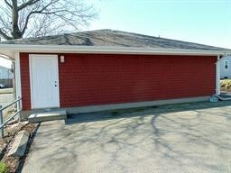
Property Record
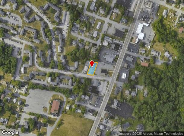
40 Shawomet Ave, Somerset, MA 02726
NEARBY LISTINGS FOR SALE OR LEASE
Property Detail
40 Shawomet Ave
SOME-000005C-000000-000274
Somerset Moss Const Co
Medicalbuilding
Bristol
X
Massachusetts
25005C0332G
274
2025
0.18 AC
2025
Attleboro/New Bedford
644101
Boston
1,386 SF
Providence-Warwick, RI-MA
DEMOGRAPHICS near 40 Shawomet Ave
1 Mile
3 Mile
5 Mile
2024 Total Population
6,163
54,381
127,629
2029 Population
6,108
54,206
126,933
Pop Growth 2024-2029
(0.89%)
(0.32%)
(0.55%)
Average Age
44
43
41
2024 Total Households
2,484
22,742
54,175
HH Growth 2024-2029
(0.93%)
(0.31%)
(0.55%)
Median Household Inc
$92,486
$71,074
$58,201
Avg Household Size
2.40
2.30
2.30
2024 Avg HH Vehicles
2.00
2.00
2.00
Median Home Value
$367,529
$370,256
$367,108
Median Year Built
1956
1959
1951
Nearby Places
Map Layers
Map Styles
 Street
 Aerial
- Restaurants
- Banks
- Shops
- Fitness
- Groceries
PUBLIC TRANSPORTATION
AIRPORT
Rhode Island Tf Green International
DRIVE
WALK
Distance
Rhode Island Tf Green International
37 min
23.4 mi
Freight Ports
Port of New Bedford Harbor
DRIVE
WALK
Distance
Port of New Bedford Harbor
28 min
18.4 mi
SALE & LEASE HISTORY
LISTING DATE
SALE/LEASE

Jul 29, 2019
For Sale
Nearby Properties
Address
Land Use
TOTAL SIZE
Lot Size
Zoning
Address
Land Use
TOTAL SIZE
Lot Size
Zoning
634,182 SF
63.86 AC
N/A
Address
Land Use
TOTAL SIZE
Lot Size
Zoning
226,473 SF
29.10 AC
R1
Address
Land Use
TOTAL SIZE
Lot Size
Zoning
203,989 SF
2.01 AC
A-2
Address
Land Use
TOTAL SIZE
Lot Size
Zoning
14.30 AC
G
Address
Land Use
TOTAL SIZE
Lot Size
Zoning
0.06 AC
A-2
Address
Land Use
TOTAL SIZE
Lot Size
Zoning
90.84 AC
N/A
Address
Land Use
TOTAL SIZE
Lot Size
Zoning
115,119 SF
151.54 AC
WR
Address
Land Use
TOTAL SIZE
Lot Size
Zoning
599,760 SF
33.60 AC
INPK
Address
Land Use
TOTAL SIZE
Lot Size
Zoning
105,949 SF
25.21 AC
R1
Address
Land Use
TOTAL SIZE
Lot Size
Zoning
104,822 SF
16.61 AC
R1
Address
Land Use
TOTAL SIZE
Lot Size
Zoning
17.18 AC
IND
Address
Land Use
TOTAL SIZE
Lot Size
Zoning
53.87 AC
N/A
Address
Land Use
TOTAL SIZE
Lot Size
Zoning
136,622 SF
55.54 AC
S
Address
Land Use
TOTAL SIZE
Lot Size
Zoning
10 AC
B
Address
Land Use
TOTAL SIZE
Lot Size
Zoning
126,146 SF
1.18 AC
A-2
Address
Land Use
TOTAL SIZE
Lot Size
Zoning
18.65 AC
A-2
Address
Land Use
TOTAL SIZE
Lot Size
Zoning
85,692 SF
4.05 AC
S
Address
Land Use
TOTAL SIZE
Lot Size
Zoning
255,600 SF
12.46 AC
R4
Address
Land Use
TOTAL SIZE
Lot Size
Zoning
28,438 SF
245 AC
C
Address
Land Use
TOTAL SIZE
Lot Size
Zoning
497,656 SF
30.47 AC
INPK
Address
Land Use
TOTAL SIZE
Lot Size
Zoning
26.51 AC
G
Address
Land Use
TOTAL SIZE
Lot Size
Zoning
3,150 SF
7.91 AC
S
Address
Land Use
TOTAL SIZE
Lot Size
Zoning
155,364 SF
15.27 AC
C
Address
Land Use
TOTAL SIZE
Lot Size
Zoning
119,932 SF
4.79 AC
G
Address
Land Use
TOTAL SIZE
Lot Size
Zoning
136,814 SF
4.07 AC
IND
Address
Land Use
TOTAL SIZE
Lot Size
Zoning
143,084 SF
12.60 AC
R1
Address
Land Use
TOTAL SIZE
Lot Size
Zoning
341,531 SF
17.57 AC
INPK
Address
Land Use
TOTAL SIZE
Lot Size
Zoning
114,424 SF
12.94 AC
C
Address
Land Use
TOTAL SIZE
Lot Size
Zoning
199,138 SF
15.10 AC
INPK
Address
Land Use
TOTAL SIZE
Lot Size
Zoning
6.48 AC
G
The World's #1 Commercial Real Estate Marketplace
Connect with us
© 2025 CoStar Group
The information above has been obtained from sources believed reliable. While we do not doubt its accuracy we have not verified it and make no guarantee, warranty or representation about it. It is your responsibility to independently confirm its accuracy and completeness. Any projections, opinions, assumptions, or estimates used are for example only and do not represent the current or future performance of the property. The value of this transaction to you depends on tax and other factors which should be evaluated by your tax, financial, and legal advisors. You and your advisors should conduct a careful, independent investigation of the property to determine to your satisfaction the suitability of the property for your needs.