Property Record
40 Silva Ln, Dracut, MA 01826
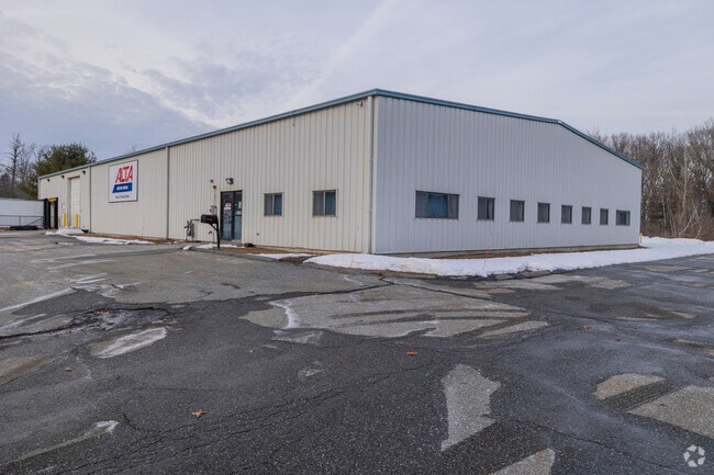

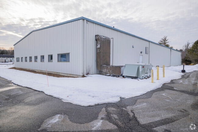
Property Detail
40 Silva Ln
DRAC-000021-000016-000003
Middlesex
Commercialbuilding
Massachusetts
I1
3
B and X Area of moderate flood hazard, usually the area between the limits of the 100-year and 500-year floods.
2.60 AC
2025
Groton/Townsend
2025
Boston
314302
Boston-Cambridge-Newton, MA-NH
12,000 SF
NEARBY LISTINGS FOR SALE OR LEASE
DEMOGRAPHICS near 40 Silva Ln
1 mile
3 mile
5 mile
2025 Total Population
1,627
28,481
189,295
2030 Population
1,725
29,492
193,013
Pop Growth 2025-2030
+ 6.02%
+ 3.55%
+ 1.96%
Average Age
40
42
39
2025 Total Households
507
10,143
68,170
HH Growth 2025-2030
+ 6.11%
+ 3.50%
+ 2.15%
Median Household Inc
$139,889
$129,405
$83,109
Avg Household Size
3.20
2.80
2.60
2025 Avg HH Vehicles
2.00
2.00
2.00
Median Home Value
$686,327
$633,749
$493,029
Median Year Built
1990
1978
1962
Nearby Places
Map Layers
Map Styles
 Street
 Aerial
Transit
 Traffic
 Biking
Places
Listings with unknown addresses are not visible on the map
- Restaurants
- Banks
- Shops
- Fitness
- Groceries
PUBLIC TRANSPORTATION
COMMUTER RAIL
Lowell (Lowell Line - Massachusetts Bay Transportation Authority Commuter Rail (Purple Line))
Drive
Walk
Distance
Lowell (Lowell Line - Massachusetts Bay Transportation Authority Commuter Rail (Purple Line))
13 min
6.0 mi
Lawrence (Haverhill Line - Massachusetts Bay Transportation Authority Commuter Rail (Purple Line))
Drive
Walk
Distance
Lawrence (Haverhill Line - Massachusetts Bay Transportation Authority Commuter Rail (Purple Line))
14 min
6.9 mi
AIRPORT
Manchester Boston Regional
Drive
Walk
Distance
Manchester Boston Regional
43 min
28.0 mi
General Edward Lawrence Logan International
Drive
Walk
Distance
General Edward Lawrence Logan International
43 min
31.7 mi
Freight Ports
Port of Boston
Drive
Walk
Distance
Port of Boston
44 min
31.4 mi
SALE & LEASE HISTORY
LISTING DATE
SALE/LEASE

Jul 26, 2024
For Sale
Nearby Properties
Address
Land Use
TOTAL SIZE
Lot Size
Zoning
Address
Land Use
TOTAL SIZE
Lot Size
Zoning
52.02 AC
ID
Address
Land Use
TOTAL SIZE
Lot Size
Zoning
309.16 AC
ID2
Address
Land Use
TOTAL SIZE
Lot Size
Zoning
144.01 AC
ID
Address
Land Use
TOTAL SIZE
Lot Size
Zoning
382,753 SF
25.86 AC
ID2
Address
Land Use
TOTAL SIZE
Lot Size
Zoning
803 SF
3.29 AC
R1
Address
Land Use
TOTAL SIZE
Lot Size
Zoning
96.66 AC
ID
Address
Land Use
TOTAL SIZE
Lot Size
Zoning
210,192 SF
15.06 AC
CN
Address
Land Use
TOTAL SIZE
Lot Size
Zoning
152,040 SF
9.10 AC
SRC
Address
Land Use
TOTAL SIZE
Lot Size
Zoning
196,152 SF
20.20 AC
ID2
Address
Land Use
TOTAL SIZE
Lot Size
Zoning
105,949 SF
28.24 AC
ID2
Address
Land Use
TOTAL SIZE
Lot Size
Zoning
162,978 SF
13.73 AC
ID2
Address
Land Use
TOTAL SIZE
Lot Size
Zoning
150,292 SF
22.77 AC
ID2
Address
Land Use
TOTAL SIZE
Lot Size
Zoning
27.15 AC
ID
Address
Land Use
TOTAL SIZE
Lot Size
Zoning
9.10 AC
MB
Address
Land Use
TOTAL SIZE
Lot Size
Zoning
124,760 SF
13.51 AC
ID
Address
Land Use
TOTAL SIZE
Lot Size
Zoning
127,448 SF
13.14 AC
ID
Address
Land Use
TOTAL SIZE
Lot Size
Zoning
288,106 SF
20.73 AC
IL
Address
Land Use
TOTAL SIZE
Lot Size
Zoning
114,785 SF
8.51 AC
ID
Address
Land Use
TOTAL SIZE
Lot Size
Zoning
90,404 SF
6 AC
ID
Address
Land Use
TOTAL SIZE
Lot Size
Zoning
121,615 SF
9.62 AC
ID2
Address
Land Use
TOTAL SIZE
Lot Size
Zoning
105,902 SF
8.09 AC
ID
Address
Land Use
TOTAL SIZE
Lot Size
Zoning
125,896 SF
9.41 AC
ID
Address
Land Use
TOTAL SIZE
Lot Size
Zoning
27.16 AC
ID2
Address
Land Use
TOTAL SIZE
Lot Size
Zoning
120,807 SF
11 AC
R1
Address
Land Use
TOTAL SIZE
Lot Size
Zoning
88,056 SF
43.67 AC
ID2
Address
Land Use
TOTAL SIZE
Lot Size
Zoning
8 AC
R3
Address
Land Use
TOTAL SIZE
Lot Size
Zoning
95,496 SF
5.75 AC
BH
Address
Land Use
TOTAL SIZE
Lot Size
Zoning
88,818 SF
17.29 AC
ID2
Address
Land Use
TOTAL SIZE
Lot Size
Zoning
7,968 SF
5.50 AC
CN
Address
Land Use
TOTAL SIZE
Lot Size
Zoning
65,988 SF
12.16 AC
ID2
The World's #1 Commercial Real Estate Marketplace
Connect with us
© 2026 CoStar Group
The information above has been obtained from sources believed reliable. While we do not doubt its accuracy we have not verified it and make no guarantee, warranty or representation about it. It is your responsibility to independently confirm its accuracy and completeness. Any projections, opinions, assumptions, or estimates used are for example only and do not represent the current or future performance of the property. The value of this transaction to you depends on tax and other factors which should be evaluated by your tax, financial, and legal advisors. You and your advisors should conduct a careful, independent investigation of the property to determine to your satisfaction the suitability of the property for your needs.