Property Record
40 Stone Rd, Rochester, NY 14616


This Property Is For Sale
NEARBY LISTINGS FOR SALE OR LEASE
Property Detail
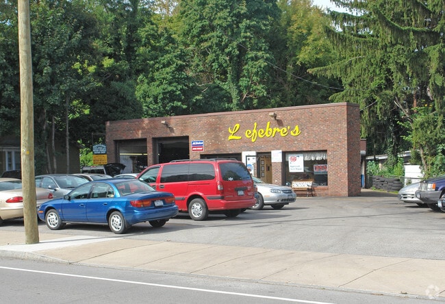
40 Stone Rd
262800-060-670-0001-014-000
1ST DIV L59 T2 S2 CRAGGSITE A 84-17 L C
Servicestation
Monroe
X
New York
36055C0182G
14.000
2025
0.62 AC
2024
Northwest
013800
Rochester
2,615 SF
Rochester, NY
DEMOGRAPHICS near 40 Stone Rd
1 Mile
3 Mile
5 Mile
2024 Total Population
14,093
95,053
222,096
2029 Population
13,883
93,877
218,881
Pop Growth 2024-2029
(1.49%)
(1.24%)
(1.45%)
Average Age
40
41
40
2024 Total Households
6,137
42,121
93,224
HH Growth 2024-2029
(1.58%)
(1.31%)
(1.50%)
Median Household Inc
$55,747
$56,822
$51,753
Avg Household Size
2.20
2.20
2.30
2024 Avg HH Vehicles
2.00
2.00
1.00
Median Home Value
$107,559
$140,350
$139,460
Median Year Built
1949
1957
1957
Nearby Places
Map Layers
Map Styles
 Street
 Aerial
- Restaurants
- Banks
- Shops
- Fitness
- Groceries
PUBLIC TRANSPORTATION
COMMUTER RAIL
DRIVE
WALK
Distance
11 min
6.0 mi
AIRPORT
Frederick Douglass/Greater Rochester International
DRIVE
WALK
Distance
Frederick Douglass/Greater Rochester International
18 min
9.9 mi
Nearby Properties
Address
Land Use
TOTAL SIZE
Lot Size
Zoning
Address
Land Use
TOTAL SIZE
Lot Size
Zoning
270,150 SF
34.40 AC
02 - SINGL
Address
Land Use
TOTAL SIZE
Lot Size
Zoning
Address
Land Use
TOTAL SIZE
Lot Size
Zoning
352,001 SF
76.90 AC
Address
Land Use
TOTAL SIZE
Lot Size
Zoning
3,200 SF
36.50 AC
Address
Land Use
TOTAL SIZE
Lot Size
Zoning
211,954 SF
9.91 AC
15
Address
Land Use
TOTAL SIZE
Lot Size
Zoning
180,406 SF
28.80 AC
Address
Land Use
TOTAL SIZE
Lot Size
Zoning
65,000 SF
5.10 AC
Address
Land Use
TOTAL SIZE
Lot Size
Zoning
37,487 SF
47.63 AC
Address
Land Use
TOTAL SIZE
Lot Size
Zoning
491,375 SF
5.90 AC
Address
Land Use
TOTAL SIZE
Lot Size
Zoning
410,400 SF
2.88 AC
Address
Land Use
TOTAL SIZE
Lot Size
Zoning
225,793 SF
32.60 AC
Address
Land Use
TOTAL SIZE
Lot Size
Zoning
227,808 SF
69.10 AC
Address
Land Use
TOTAL SIZE
Lot Size
Zoning
273,663 SF
80.37 AC
Address
Land Use
TOTAL SIZE
Lot Size
Zoning
148,440 SF
4.18 AC
Address
Land Use
TOTAL SIZE
Lot Size
Zoning
205,616 SF
3.10 AC
Address
Land Use
TOTAL SIZE
Lot Size
Zoning
Address
Land Use
TOTAL SIZE
Lot Size
Zoning
2,855 SF
243.50 AC
Address
Land Use
TOTAL SIZE
Lot Size
Zoning
179,837 SF
8.01 AC
Address
Land Use
TOTAL SIZE
Lot Size
Zoning
521,507 SF
37.98 AC
Address
Land Use
TOTAL SIZE
Lot Size
Zoning
187.40 AC
Address
Land Use
TOTAL SIZE
Lot Size
Zoning
104,880 SF
9 AC
05 - COMME
Address
Land Use
TOTAL SIZE
Lot Size
Zoning
145,943 SF
16.15 AC
05 - COMME
Address
Land Use
TOTAL SIZE
Lot Size
Zoning
3,348 SF
31.29 AC
07 - MIXED
Address
Land Use
TOTAL SIZE
Lot Size
Zoning
14,800 SF
14.91 AC
05 - COMME
Address
Land Use
TOTAL SIZE
Lot Size
Zoning
54,606 SF
5.53 AC
05 - COMME
Address
Land Use
TOTAL SIZE
Lot Size
Zoning
99,308 SF
6.80 AC
05 - COMME
Address
Land Use
TOTAL SIZE
Lot Size
Zoning
Address
Land Use
TOTAL SIZE
Lot Size
Zoning
22,308 SF
34.40 AC
02 - SINGL
Address
Land Use
TOTAL SIZE
Lot Size
Zoning
Address
Land Use
TOTAL SIZE
Lot Size
Zoning
129,096 SF
5.02 AC
05 - COMME
The World's #1 Commercial Real Estate Marketplace
Connect with us
© 2025 CoStar Group
The information above has been obtained from sources believed reliable. While we do not doubt its accuracy we have not verified it and make no guarantee, warranty or representation about it. It is your responsibility to independently confirm its accuracy and completeness. Any projections, opinions, assumptions, or estimates used are for example only and do not represent the current or future performance of the property. The value of this transaction to you depends on tax and other factors which should be evaluated by your tax, financial, and legal advisors. You and your advisors should conduct a careful, independent investigation of the property to determine to your satisfaction the suitability of the property for your needs.