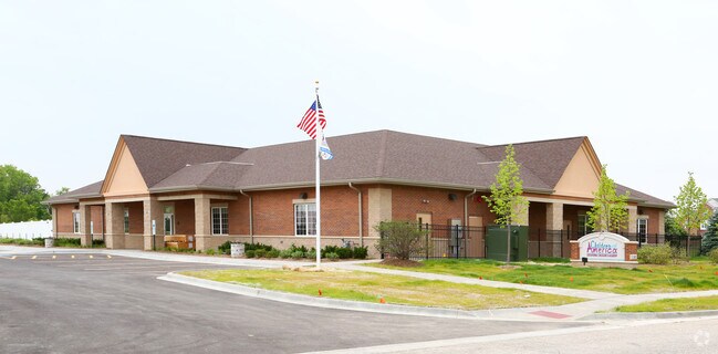
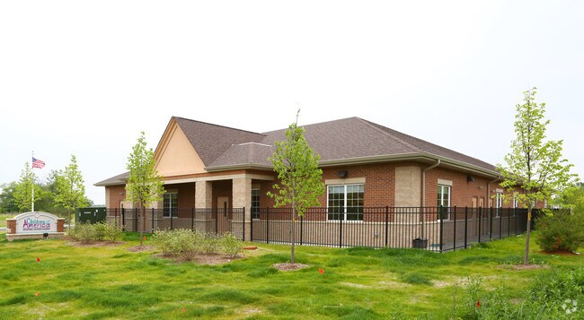
Property Record
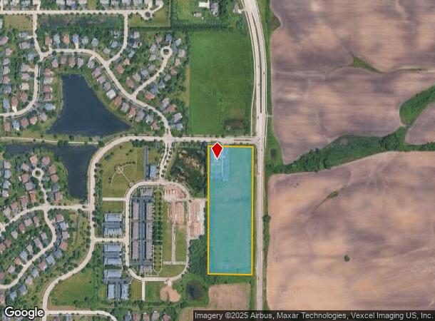
40 Us Highway 45 Pl, Lindenhurst, IL 60046

NEARBY LISTINGS FOR SALE OR LEASE
Property Detail
40 Us Highway 45 Pl
Chicago-Naperville-Elgin, IL-IN
Heritage Park Subdivision
06-01-206-110
HERITAGE PARK SUBDIVISION;UNIT 1 & 12.47% INT IN COMMON ELEM ENTS IN LINDENHURST MANOR CONDO PER DOC 7095525 PT LOT 102
Commercialbuilding
Lake
X
Illinois
17097C0042L
102
2023
1.06 AC
2024
Far North
861009
Chicago
10,000 SF
DEMOGRAPHICS near 40 Us Highway 45 Pl
1 Mile
3 Mile
5 Mile
2024 Total Population
4,642
29,711
94,674
2029 Population
4,544
29,267
93,329
Pop Growth 2024-2029
(2.11%)
(1.49%)
(1.42%)
Average Age
38
40
40
2024 Total Households
1,572
10,481
33,583
HH Growth 2024-2029
(2.35%)
(1.62%)
(1.54%)
Median Household Inc
$139,566
$116,637
$110,845
Avg Household Size
2.90
2.80
2.80
2024 Avg HH Vehicles
2.00
2.00
2.00
Median Home Value
$263,389
$265,125
$261,353
Median Year Built
1992
1990
1991
Nearby Places
Map Layers
Map Styles
 Street
 Aerial
- Restaurants
- Banks
- Shops
- Fitness
- Groceries
PUBLIC TRANSPORTATION
COMMUTER RAIL
Lake Villa Station (North Central Service - Northeast Illinois Regional Commuter Railroad (Metra))
DRIVE
WALK
Distance
Lake Villa Station (North Central Service - Northeast Illinois Regional Commuter Railroad (Metra))
11 min
4.8 mi
Round Lake Beach Station (North Central Service - Northeast Illinois Regional Commuter Railroad (Metra))
DRIVE
WALK
Distance
Round Lake Beach Station (North Central Service - Northeast Illinois Regional Commuter Railroad (Metra))
11 min
5.8 mi
AIRPORT
Chicago O'Hare International
DRIVE
WALK
Distance
Chicago O'Hare International
48 min
36.3 mi
Nearby Properties
Address
Land Use
TOTAL SIZE
Lot Size
Zoning
Address
Land Use
TOTAL SIZE
Lot Size
Zoning
1,670,193 SF
20.98 AC
Address
Land Use
TOTAL SIZE
Lot Size
Zoning
286,618 SF
11.81 AC
Address
Land Use
TOTAL SIZE
Lot Size
Zoning
763,480 SF
16.88 AC
Address
Land Use
TOTAL SIZE
Lot Size
Zoning
5,303,058 SF
26.82 AC
Address
Land Use
TOTAL SIZE
Lot Size
Zoning
951,408 SF
36.36 AC
Address
Land Use
TOTAL SIZE
Lot Size
Zoning
2,415,756 SF
12.61 AC
Address
Land Use
TOTAL SIZE
Lot Size
Zoning
79,458 SF
6.79 AC
Address
Land Use
TOTAL SIZE
Lot Size
Zoning
Address
Land Use
TOTAL SIZE
Lot Size
Zoning
119,855 SF
10.30 AC
Address
Land Use
TOTAL SIZE
Lot Size
Zoning
46,068 SF
0.65 AC
Address
Land Use
TOTAL SIZE
Lot Size
Zoning
200,944 SF
5.84 AC
Address
Land Use
TOTAL SIZE
Lot Size
Zoning
209,803 SF
3.88 AC
Address
Land Use
TOTAL SIZE
Lot Size
Zoning
84,976 SF
2.41 AC
Address
Land Use
TOTAL SIZE
Lot Size
Zoning
50,540 SF
1.54 AC
Address
Land Use
TOTAL SIZE
Lot Size
Zoning
120,611 SF
9.74 AC
Address
Land Use
TOTAL SIZE
Lot Size
Zoning
63,240 SF
7.45 AC
Address
Land Use
TOTAL SIZE
Lot Size
Zoning
39,284 SF
6.51 AC
Address
Land Use
TOTAL SIZE
Lot Size
Zoning
28,723 SF
5.78 AC
Address
Land Use
TOTAL SIZE
Lot Size
Zoning
31,652 SF
2.80 AC
Address
Land Use
TOTAL SIZE
Lot Size
Zoning
57,398 SF
5.23 AC
Address
Land Use
TOTAL SIZE
Lot Size
Zoning
28,419 SF
5.17 AC
Address
Land Use
TOTAL SIZE
Lot Size
Zoning
10,998 SF
2.50 AC
Address
Land Use
TOTAL SIZE
Lot Size
Zoning
3.53 AC
Address
Land Use
TOTAL SIZE
Lot Size
Zoning
21,772 SF
4 AC
Address
Land Use
TOTAL SIZE
Lot Size
Zoning
26,920 SF
4.43 AC
Address
Land Use
TOTAL SIZE
Lot Size
Zoning
21,420 SF
2.25 AC
Address
Land Use
TOTAL SIZE
Lot Size
Zoning
18.94 AC
Address
Land Use
TOTAL SIZE
Lot Size
Zoning
35,871 SF
0.33 AC
Address
Land Use
TOTAL SIZE
Lot Size
Zoning
20,286 SF
2.26 AC
Address
Land Use
TOTAL SIZE
Lot Size
Zoning
63,643 SF
9.12 AC
The World's #1 Commercial Real Estate Marketplace
Connect with us
© 2026 CoStar Group
The information above has been obtained from sources believed reliable. While we do not doubt its accuracy we have not verified it and make no guarantee, warranty or representation about it. It is your responsibility to independently confirm its accuracy and completeness. Any projections, opinions, assumptions, or estimates used are for example only and do not represent the current or future performance of the property. The value of this transaction to you depends on tax and other factors which should be evaluated by your tax, financial, and legal advisors. You and your advisors should conduct a careful, independent investigation of the property to determine to your satisfaction the suitability of the property for your needs.