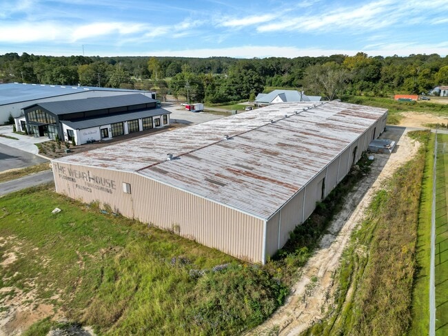
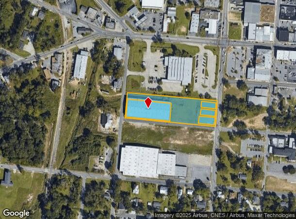
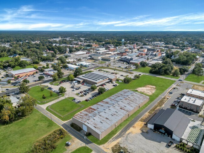
Property Record
40 W Cherry St, Statesboro, GA 30458
Current Lease Availabilities
NEARBY LISTINGS FOR SALE OR LEASE
Property Detail
40 W Cherry St
S18-000170-000
West Waters
Commercialnec
CHERRY/INSTIT S
X
Bulloch
13031C0208D
Georgia
2024
1.92 AC
2024
Downtown Statesboro
110401
Other Market Areas
36,000 SF
Statesboro, GA
DEMOGRAPHICS near 40 W Cherry St
1 Mile
3 Mile
5 Mile
2024 Total Population
7,057
35,215
50,644
2029 Population
7,797
38,185
55,220
Pop Growth 2024-2029
+ 10.49%
+ 8.43%
+ 9.04%
Average Age
37
32
33
2024 Total Households
2,860
13,112
18,828
HH Growth 2024-2029
+ 11.29%
+ 9.23%
+ 9.84%
Median Household Inc
$40,789
$46,337
$52,229
Avg Household Size
2.30
2.30
2.40
2024 Avg HH Vehicles
2.00
2.00
2.00
Median Home Value
$140,131
$173,127
$201,905
Median Year Built
1969
1988
1991
Nearby Places
- Restaurants
- Banks
- Shops
- Fitness
- Groceries
Nearby Properties
Address
Land Use
TOTAL SIZE
Lot Size
Zoning
Address
Land Use
TOTAL SIZE
Lot Size
Zoning
612.82 AC
EXPT
Address
Land Use
TOTAL SIZE
Lot Size
Zoning
250,037 SF
30.67 AC
O
Address
Land Use
TOTAL SIZE
Lot Size
Zoning
10,228 SF
24.06 AC
R4
Address
Land Use
TOTAL SIZE
Lot Size
Zoning
7,470 SF
39.71 AC
CR
Address
Land Use
TOTAL SIZE
Lot Size
Zoning
11,490 SF
10.01 AC
R4
Address
Land Use
TOTAL SIZE
Lot Size
Zoning
5.54 AC
EXPT
Address
Land Use
TOTAL SIZE
Lot Size
Zoning
146,137 SF
17.78 AC
CR
Address
Land Use
TOTAL SIZE
Lot Size
Zoning
8,824 SF
29.25 AC
PUD/R4
Address
Land Use
TOTAL SIZE
Lot Size
Zoning
41.09 AC
R3/R15
Address
Land Use
TOTAL SIZE
Lot Size
Zoning
55 AC
EXPT
Address
Land Use
TOTAL SIZE
Lot Size
Zoning
3,659 SF
38.60 AC
R40
Address
Land Use
TOTAL SIZE
Lot Size
Zoning
37,918 SF
9.93 AC
R4
Address
Land Use
TOTAL SIZE
Lot Size
Zoning
3,951 SF
20.19 AC
CR
Address
Land Use
TOTAL SIZE
Lot Size
Zoning
950 SF
12.73 AC
PUD/R4
Address
Land Use
TOTAL SIZE
Lot Size
Zoning
4,622 SF
17 AC
R4/CR
Address
Land Use
TOTAL SIZE
Lot Size
Zoning
449,500 SF
118.42 AC
LI
Address
Land Use
TOTAL SIZE
Lot Size
Zoning
22,392 SF
13.97 AC
R4
Address
Land Use
TOTAL SIZE
Lot Size
Zoning
102,529 SF
18.07 AC
CR
Address
Land Use
TOTAL SIZE
Lot Size
Zoning
4,450 SF
26.60 AC
R4
Address
Land Use
TOTAL SIZE
Lot Size
Zoning
190,382 SF
23.53 AC
CR
Address
Land Use
TOTAL SIZE
Lot Size
Zoning
153.74 AC
R40
Address
Land Use
TOTAL SIZE
Lot Size
Zoning
60,537 SF
8.76 AC
CR
Address
Land Use
TOTAL SIZE
Lot Size
Zoning
12,010 SF
21.14 AC
HC
Address
Land Use
TOTAL SIZE
Lot Size
Zoning
8,394 SF
14.34 AC
R4/CR
Address
Land Use
TOTAL SIZE
Lot Size
Zoning
13 AC
R20
Address
Land Use
TOTAL SIZE
Lot Size
Zoning
4,969 SF
13.52 AC
PUD/R4
Address
Land Use
TOTAL SIZE
Lot Size
Zoning
1,893 SF
10.73 AC
R4
Address
Land Use
TOTAL SIZE
Lot Size
Zoning
21.05 AC
PUD/R4
Address
Land Use
TOTAL SIZE
Lot Size
Zoning
449,500 SF
118.42 AC
LI
Address
Land Use
TOTAL SIZE
Lot Size
Zoning
76,118 SF
12.31 AC
CR
The World's #1 Commercial Real Estate Marketplace
Connect with us
© 2025 CoStar Group
The information above has been obtained from sources believed reliable. While we do not doubt its accuracy we have not verified it and make no guarantee, warranty or representation about it. It is your responsibility to independently confirm its accuracy and completeness. Any projections, opinions, assumptions, or estimates used are for example only and do not represent the current or future performance of the property. The value of this transaction to you depends on tax and other factors which should be evaluated by your tax, financial, and legal advisors. You and your advisors should conduct a careful, independent investigation of the property to determine to your satisfaction the suitability of the property for your needs.