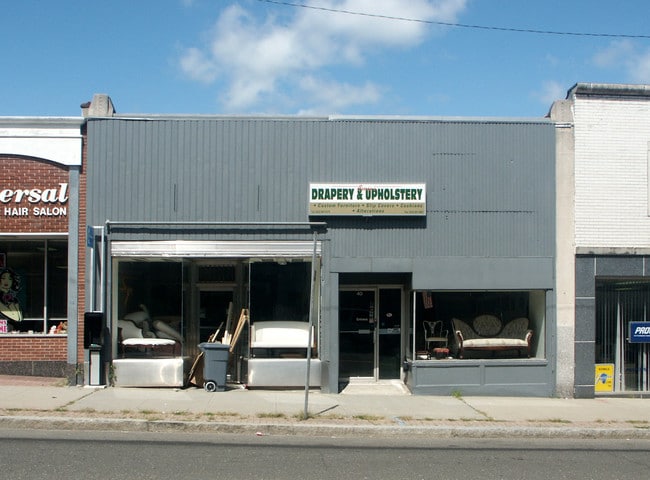
Property Record
40 Wall St, Norwalk, CT 06850

Property Detail
40 Wall St
NORW-000001-000037-000003
Western Ct
Storebuilding
Connecticut
CBDA
3
B and X Area of moderate flood hazard, usually the area between the limits of the 100-year and 500-year floods.
0.04 AC
2025
Norwalk
2025
Westchester/So Connecticut
043700
Bridgeport-Stamford-Danbury, CT
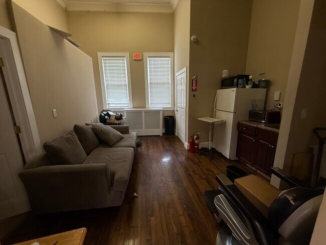
1,932 SF
NEARBY LISTINGS FOR SALE OR LEASE
DEMOGRAPHICS near 40 Wall St
1 mile
3 mile
5 mile
2025 Total Population
22,099
93,636
145,599
2030 Population
22,449
95,369
149,081
Pop Growth 2025-2030
+ 1.58%
+ 1.85%
+ 2.39%
Average Age
40
41
41
2025 Total Households
8,987
37,009
55,034
HH Growth 2025-2030
+ 1.66%
+ 1.95%
+ 2.41%
Median Household Inc
$104,134
$107,016
$131,175
Avg Household Size
2.40
2.40
2.60
2025 Avg HH Vehicles
2.00
2.00
2.00
Median Home Value
$496,222
$632,651
$829,779
Median Year Built
1963
1966
1965
Nearby Places
Map Layers
Map Styles
 Street
 Aerial
Layers
 Traffic
 Biking
Places
Listings with unknown addresses are not visible on the map
- Restaurants
- Banks
- Shops
- Fitness
- Groceries
PUBLIC TRANSPORTATION
COMMUTER RAIL
East Norwalk Station (New Haven Line - Metro-North Commuter Railroad Company (Metro-North))
Drive
Walk
Distance
East Norwalk Station (New Haven Line - Metro-North Commuter Railroad Company (Metro-North))
2 min
1.2 mi
South Norwalk Station (New Haven Line - Metro-North Commuter Railroad Company (Metro-North))
Drive
Walk
Distance
South Norwalk Station (New Haven Line - Metro-North Commuter Railroad Company (Metro-North))
4 min
1.8 mi
AIRPORT
Westchester County
Drive
Walk
Distance
Westchester County
34 min
22.4 mi
Tweed/New Haven
Drive
Walk
Distance
Tweed/New Haven
56 min
35.9 mi
Freight Ports
Port of New Haven
Drive
Walk
Distance
Port of New Haven
49 min
33.7 mi
SALE & LEASE HISTORY
LISTING DATE
SALE/LEASE

Sep 18, 2025
For Lease
Nearby Properties
Address
Land Use
TOTAL SIZE
Lot Size
Zoning
Address
Land Use
TOTAL SIZE
Lot Size
Zoning
4.49 AC
CBDB
Address
Land Use
TOTAL SIZE
Lot Size
Zoning
749,988 SF
4.52 AC
CBDB
Address
Land Use
TOTAL SIZE
Lot Size
Zoning
339,272 SF
4.07 AC
EO
Address
Land Use
TOTAL SIZE
Lot Size
Zoning
6.80 AC
B2
Address
Land Use
TOTAL SIZE
Lot Size
Zoning
226,920 SF
24.75 AC
B
Address
Land Use
TOTAL SIZE
Lot Size
Zoning
4.44 AC
CBDB
Address
Land Use
TOTAL SIZE
Lot Size
Zoning
248,486 SF
6.57 AC
EO
Address
Land Use
TOTAL SIZE
Lot Size
Zoning
292,852 SF
3.38 AC
EO
Address
Land Use
TOTAL SIZE
Lot Size
Zoning
254,126 SF
3.33 AC
EO
Address
Land Use
TOTAL SIZE
Lot Size
Zoning
269,100 SF
38.37 AC
RI
Address
Land Use
TOTAL SIZE
Lot Size
Zoning
320,588 SF
3.22 AC
EO
Address
Land Use
TOTAL SIZE
Lot Size
Zoning
254,126 SF
3.06 AC
EO
Address
Land Use
TOTAL SIZE
Lot Size
Zoning
252,316 SF
Address
Land Use
TOTAL SIZE
Lot Size
Zoning
271,344 SF
2.36 AC
EO
Address
Land Use
TOTAL SIZE
Lot Size
Zoning
124,373 SF
13.87 AC
A2
Address
Land Use
TOTAL SIZE
Lot Size
Zoning
101,688 SF
5 AC
RI
Address
Land Use
TOTAL SIZE
Lot Size
Zoning
17 AC
A2
Address
Land Use
TOTAL SIZE
Lot Size
Zoning
21.34 AC
B2
Address
Land Use
TOTAL SIZE
Lot Size
Zoning
Address
Land Use
TOTAL SIZE
Lot Size
Zoning
128,459 SF
1.49 AC
I1
Address
Land Use
TOTAL SIZE
Lot Size
Zoning
13.46 AC
RB
Address
Land Use
TOTAL SIZE
Lot Size
Zoning
130,394 SF
28.72 AC
B
Address
Land Use
TOTAL SIZE
Lot Size
Zoning
13.10 AC
RBD
Address
Land Use
TOTAL SIZE
Lot Size
Zoning
108,119 SF
3.62 AC
I1
Address
Land Use
TOTAL SIZE
Lot Size
Zoning
41.63 AC
A2
Address
Land Use
TOTAL SIZE
Lot Size
Zoning
200,704 SF
Address
Land Use
TOTAL SIZE
Lot Size
Zoning
175,791 SF
1.58 AC
CBDB
Address
Land Use
TOTAL SIZE
Lot Size
Zoning
9.76 AC
B1
Address
Land Use
TOTAL SIZE
Lot Size
Zoning
23.15 AC
A
Address
Land Use
TOTAL SIZE
Lot Size
Zoning
12.30 AC
AA
The World's #1 Commercial Real Estate Marketplace
Connect with us
© 2026 CoStar Group
The information above has been obtained from sources believed reliable. While we do not doubt its accuracy we have not verified it and make no guarantee, warranty or representation about it. It is your responsibility to independently confirm its accuracy and completeness. Any projections, opinions, assumptions, or estimates used are for example only and do not represent the current or future performance of the property. The value of this transaction to you depends on tax and other factors which should be evaluated by your tax, financial, and legal advisors. You and your advisors should conduct a careful, independent investigation of the property to determine to your satisfaction the suitability of the property for your needs.