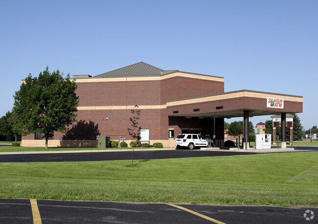
Property Record
400 4Th Ave Ne, Saint Joseph, MN 56374


NEARBY LISTINGS FOR SALE OR LEASE
Property Detail
400 4Th Ave Ne
St. Cloud, MN
Roske Addition
84.53795.0220
PT OF LOT 1 BLK 2 LYING W'LY OF FDL BEG AT SW CORN OF OUTLOT B - N ALG W LN OF OUTLOT B & ITS EXT TO THE N LN OF LOT 1 BLK 2
Financialbuilding
Stearns
X
Minnesota
27145C0610E
1b
2025
2.37 AC
2025
Stearns County
011308
Minneapolis/St Paul
7,620 SF
DEMOGRAPHICS near 400 4Th Ave Ne
1 Mile
3 Mile
5 Mile
2024 Total Population
6,281
10,802
32,987
2029 Population
6,492
11,149
34,174
Pop Growth 2024-2029
+ 3.36%
+ 3.21%
+ 3.60%
Average Age
33
36
38
2024 Total Households
1,931
3,706
12,908
HH Growth 2024-2029
+ 3.78%
+ 3.48%
+ 3.77%
Median Household Inc
$67,941
$73,551
$63,766
Avg Household Size
2.40
2.40
2.40
2024 Avg HH Vehicles
2.00
2.00
2.00
Median Home Value
$197,499
$221,406
$232,129
Median Year Built
1991
1993
1996
Nearby Places
Map Layers
Map Styles
 Street
 Aerial
- Restaurants
- Banks
- Shops
- Fitness
- Groceries
PUBLIC TRANSPORTATION
COMMUTER RAIL
St. Cloud Amtrak Station (Empire Builder - Amtrak)
DRIVE
WALK
Distance
St. Cloud Amtrak Station (Empire Builder - Amtrak)
16 min
8.8 mi
Freight Ports
Port Milwaukee
DRIVE
WALK
Distance
Port Milwaukee
456 min
412.1 mi
Nearby Properties
Address
Land Use
TOTAL SIZE
Lot Size
Zoning
Address
Land Use
TOTAL SIZE
Lot Size
Zoning
52,983 SF
22 AC
Address
Land Use
TOTAL SIZE
Lot Size
Zoning
148,150 SF
71.46 AC
Address
Land Use
TOTAL SIZE
Lot Size
Zoning
19.06 AC
Address
Land Use
TOTAL SIZE
Lot Size
Zoning
628,000 SF
40.51 AC
PUD16
Address
Land Use
TOTAL SIZE
Lot Size
Zoning
269,390 SF
15.77 AC
Address
Land Use
TOTAL SIZE
Lot Size
Zoning
146,285 SF
19.10 AC
Address
Land Use
TOTAL SIZE
Lot Size
Zoning
51.70 AC
PL20B2
Address
Land Use
TOTAL SIZE
Lot Size
Zoning
288,861 SF
30.27 AC
I3
Address
Land Use
TOTAL SIZE
Lot Size
Zoning
Address
Land Use
TOTAL SIZE
Lot Size
Zoning
320,450 SF
26.20 AC
I3
Address
Land Use
TOTAL SIZE
Lot Size
Zoning
3,088 SF
67.89 AC
PL20B1
Address
Land Use
TOTAL SIZE
Lot Size
Zoning
33,796 SF
4.83 AC
Address
Land Use
TOTAL SIZE
Lot Size
Zoning
13,219 SF
2.19 AC
Address
Land Use
TOTAL SIZE
Lot Size
Zoning
44,631 SF
15.01 AC
Address
Land Use
TOTAL SIZE
Lot Size
Zoning
27,694 SF
7.17 AC
Address
Land Use
TOTAL SIZE
Lot Size
Zoning
4.15 AC
Address
Land Use
TOTAL SIZE
Lot Size
Zoning
Address
Land Use
TOTAL SIZE
Lot Size
Zoning
Address
Land Use
TOTAL SIZE
Lot Size
Zoning
15,545 SF
25.34 AC
Address
Land Use
TOTAL SIZE
Lot Size
Zoning
39,604 SF
11.29 AC
Address
Land Use
TOTAL SIZE
Lot Size
Zoning
100,010 SF
10 AC
Address
Land Use
TOTAL SIZE
Lot Size
Zoning
88,290 SF
5 AC
Address
Land Use
TOTAL SIZE
Lot Size
Zoning
69,151 SF
4.34 AC
PUD32
Address
Land Use
TOTAL SIZE
Lot Size
Zoning
16,562 SF
3.70 AC
Address
Land Use
TOTAL SIZE
Lot Size
Zoning
39,544 SF
6.92 AC
Address
Land Use
TOTAL SIZE
Lot Size
Zoning
19,800 SF
10 AC
Address
Land Use
TOTAL SIZE
Lot Size
Zoning
Address
Land Use
TOTAL SIZE
Lot Size
Zoning
The World's #1 Commercial Real Estate Marketplace
Connect with us
© 2025 CoStar Group
The information above has been obtained from sources believed reliable. While we do not doubt its accuracy we have not verified it and make no guarantee, warranty or representation about it. It is your responsibility to independently confirm its accuracy and completeness. Any projections, opinions, assumptions, or estimates used are for example only and do not represent the current or future performance of the property. The value of this transaction to you depends on tax and other factors which should be evaluated by your tax, financial, and legal advisors. You and your advisors should conduct a careful, independent investigation of the property to determine to your satisfaction the suitability of the property for your needs.