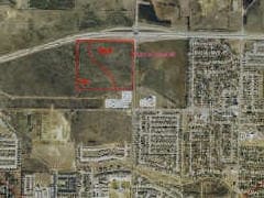
Property Record
400 Ame Dr, Denton, TX 76207


Property Detail
400 Ame Dr
Dallas-Fort Worth-Arlington, TX
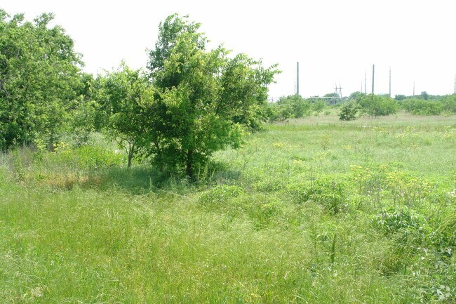
LOCUST LP ADDITION BLK A LOT 5
R580938
DENTON
Apartment
Texas
B and X Area of moderate flood hazard, usually the area between the limits of the 100-year and 500-year floods.
5
2024
5.88 AC
2025
Denton
020404
Dallas/Ft Worth
175,943 SF
NEARBY LISTINGS FOR SALE OR LEASE
DEMOGRAPHICS near 400 Ame Dr
1 mile
3 mile
5 mile
2024 Total Population
10,625
51,575
112,043
2029 Population
12,122
58,492
126,596
Pop Growth 2024-2029
+ 14.09%
+ 13.41%
+ 12.99%
Average Age
35
37
35
2024 Total Households
4,039
20,293
44,781
HH Growth 2024-2029
+ 14.04%
+ 13.69%
+ 13.32%
Median Household Inc
$82,662
$78,452
$60,735
Avg Household Size
2.60
2.40
2.30
2024 Avg HH Vehicles
2.00
2.00
2.00
Median Home Value
$316,016
$303,528
$308,969
Median Year Built
1999
1986
1989
Nearby Places
Map Layers
Map Styles
 Street
 Aerial
Transit
 Traffic
 Biking
Places
Listings with unknown addresses are not visible on the map
- Restaurants
- Banks
- Shops
- Fitness
- Groceries
PUBLIC TRANSPORTATION
COMMUTER RAIL
Downtown Denton Transit Center (A-train - Denton County Transportation Authority)
Drive
Walk
Distance
Downtown Denton Transit Center (A-train - Denton County Transportation Authority)
8 min
3.9 mi
Medpark Station (A-train - Denton County Transportation Authority)
Drive
Walk
Distance
Medpark Station (A-train - Denton County Transportation Authority)
15 min
7.8 mi
AIRPORT
Dallas-Fort Worth International
Drive
Walk
Distance
Dallas-Fort Worth International
40 min
30.0 mi
Freight Ports
Port of Shreveport
Drive
Walk
Distance
Port of Shreveport
259 min
236.6 mi
Nearby Properties
Address
Land Use
TOTAL SIZE
Lot Size
Zoning
Address
Land Use
TOTAL SIZE
Lot Size
Zoning
490,000 SF
144.26 AC
Address
Land Use
TOTAL SIZE
Lot Size
Zoning
490,000 SF
27.69 AC
Address
Land Use
TOTAL SIZE
Lot Size
Zoning
347,844 SF
14.09 AC
Address
Land Use
TOTAL SIZE
Lot Size
Zoning
576,664 SF
189.26 AC
Address
Land Use
TOTAL SIZE
Lot Size
Zoning
368,434 SF
16.39 AC
Address
Land Use
TOTAL SIZE
Lot Size
Zoning
343,800 SF
10.95 AC
Address
Land Use
TOTAL SIZE
Lot Size
Zoning
373,498 SF
54.27 AC
Address
Land Use
TOTAL SIZE
Lot Size
Zoning
262,008 SF
11.11 AC
Address
Land Use
TOTAL SIZE
Lot Size
Zoning
285,578 SF
42.28 AC
Address
Land Use
TOTAL SIZE
Lot Size
Zoning
298,744 SF
32.12 AC
Address
Land Use
TOTAL SIZE
Lot Size
Zoning
702,810 SF
37.91 AC
Address
Land Use
TOTAL SIZE
Lot Size
Zoning
362,191 SF
6.81 AC
Address
Land Use
TOTAL SIZE
Lot Size
Zoning
149,145 SF
31.45 AC
Address
Land Use
TOTAL SIZE
Lot Size
Zoning
216,314 SF
22.10 AC
Address
Land Use
TOTAL SIZE
Lot Size
Zoning
374,520 SF
23.62 AC
Address
Land Use
TOTAL SIZE
Lot Size
Zoning
300,000 SF
11.31 AC
Address
Land Use
TOTAL SIZE
Lot Size
Zoning
261,847 SF
2.81 AC
Address
Land Use
TOTAL SIZE
Lot Size
Zoning
216,321 SF
16.97 AC
Address
Land Use
TOTAL SIZE
Lot Size
Zoning
378,000 SF
14.94 AC
Address
Land Use
TOTAL SIZE
Lot Size
Zoning
213,040 SF
11.59 AC
Address
Land Use
TOTAL SIZE
Lot Size
Zoning
203,238 SF
15.98 AC
14E
Address
Land Use
TOTAL SIZE
Lot Size
Zoning
150,162 SF
40.40 AC
Address
Land Use
TOTAL SIZE
Lot Size
Zoning
265,448 SF
6.67 AC
Address
Land Use
TOTAL SIZE
Lot Size
Zoning
292,407 SF
7.07 AC
Address
Land Use
TOTAL SIZE
Lot Size
Zoning
147,492 SF
11.39 AC
22G
Address
Land Use
TOTAL SIZE
Lot Size
Zoning
367,488 SF
22.80 AC
Address
Land Use
TOTAL SIZE
Lot Size
Zoning
336,342 SF
11.81 AC
Address
Land Use
TOTAL SIZE
Lot Size
Zoning
210,794 SF
11.43 AC
Address
Land Use
TOTAL SIZE
Lot Size
Zoning
162,500 SF
11.04 AC
The World's #1 Commercial Real Estate Marketplace
Connect with us
© 2026 CoStar Group
The information above has been obtained from sources believed reliable. While we do not doubt its accuracy we have not verified it and make no guarantee, warranty or representation about it. It is your responsibility to independently confirm its accuracy and completeness. Any projections, opinions, assumptions, or estimates used are for example only and do not represent the current or future performance of the property. The value of this transaction to you depends on tax and other factors which should be evaluated by your tax, financial, and legal advisors. You and your advisors should conduct a careful, independent investigation of the property to determine to your satisfaction the suitability of the property for your needs.