Property Record
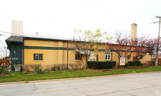
400 Anthony Trl, Northbrook, IL 60062


Current Lease Availabilities
NEARBY LISTINGS FOR SALE OR LEASE
Property Detail
400 Anthony Trl
Industrialgeneral
Cook
X
Illinois
17097C0288K
1.08 AC
2023
North Cook
2024
Chicago
801601
Chicago-Naperville-Elgin, IL-IN-WI
17,250 SF
04-05-400-022-0000
DEMOGRAPHICS near 400 Anthony Trl
1 Mile
3 Mile
5 Mile
2024 Total Population
7,201
70,291
197,487
2029 Population
7,070
68,842
193,615
Pop Growth 2024-2029
(1.82%)
(2.06%)
(1.96%)
Average Age
46
44
43
2024 Total Households
2,806
26,504
74,286
HH Growth 2024-2029
(2.07%)
(2.34%)
(2.13%)
Median Household Inc
$114,198
$138,815
$114,115
Avg Household Size
2.50
2.60
2.60
2024 Avg HH Vehicles
2.00
2.00
2.00
Median Home Value
$563,643
$571,921
$495,029
Median Year Built
1978
1973
1975
Nearby Places
Map Layers
Map Styles
 Street
 Aerial
- Restaurants
- Banks
- Shops
- Fitness
- Groceries
PUBLIC TRANSPORTATION
COMMUTER RAIL
Lake Cook Station (Milwaukee District North Line - Northeast Illinois Regional Commuter Railroad (Metra))
DRIVE
WALK
Distance
Lake Cook Station (Milwaukee District North Line - Northeast Illinois Regional Commuter Railroad (Metra))
4 min
1.2 mi
Deerfield Station (Milwaukee District North Line - Northeast Illinois Regional Commuter Railroad (Metra))
DRIVE
WALK
Distance
Deerfield Station (Milwaukee District North Line - Northeast Illinois Regional Commuter Railroad (Metra))
6 min
2.5 mi
AIRPORT
Chicago O'Hare International
DRIVE
WALK
Distance
Chicago O'Hare International
23 min
14.2 mi
Chicago Midway International
DRIVE
WALK
Distance
Chicago Midway International
50 min
31.5 mi
Nearby Properties
Address
Land Use
TOTAL SIZE
Lot Size
Zoning
Address
Land Use
TOTAL SIZE
Lot Size
Zoning
6,783,684 SF
69.84 AC
Address
Land Use
TOTAL SIZE
Lot Size
Zoning
815,308 SF
12.95 AC
Address
Land Use
TOTAL SIZE
Lot Size
Zoning
708,522 SF
17.11 AC
Address
Land Use
TOTAL SIZE
Lot Size
Zoning
301,050 SF
11.22 AC
Address
Land Use
TOTAL SIZE
Lot Size
Zoning
864,590 SF
2.64 AC
Address
Land Use
TOTAL SIZE
Lot Size
Zoning
530,208 SF
Address
Land Use
TOTAL SIZE
Lot Size
Zoning
21.58 AC
Address
Land Use
TOTAL SIZE
Lot Size
Zoning
1,049,337 SF
24.57 AC
Address
Land Use
TOTAL SIZE
Lot Size
Zoning
653,040 SF
7.96 AC
Address
Land Use
TOTAL SIZE
Lot Size
Zoning
8,586,994 SF
10.41 AC
Address
Land Use
TOTAL SIZE
Lot Size
Zoning
443,916 SF
5.61 AC
Address
Land Use
TOTAL SIZE
Lot Size
Zoning
188,987 SF
6.65 AC
Address
Land Use
TOTAL SIZE
Lot Size
Zoning
419,812 SF
13.88 AC
Address
Land Use
TOTAL SIZE
Lot Size
Zoning
32.61 AC
Address
Land Use
TOTAL SIZE
Lot Size
Zoning
534,816 SF
6.98 AC
Address
Land Use
TOTAL SIZE
Lot Size
Zoning
186,646 SF
26.69 AC
Address
Land Use
TOTAL SIZE
Lot Size
Zoning
349,846 SF
5.11 AC
Address
Land Use
TOTAL SIZE
Lot Size
Zoning
333,202 SF
13.88 AC
Address
Land Use
TOTAL SIZE
Lot Size
Zoning
221,786 SF
6.33 AC
Address
Land Use
TOTAL SIZE
Lot Size
Zoning
46.27 AC
Address
Land Use
TOTAL SIZE
Lot Size
Zoning
362,944 SF
12.74 AC
Address
Land Use
TOTAL SIZE
Lot Size
Zoning
167,843 SF
12.55 AC
Address
Land Use
TOTAL SIZE
Lot Size
Zoning
6.32 AC
Address
Land Use
TOTAL SIZE
Lot Size
Zoning
215,633 SF
9.78 AC
Address
Land Use
TOTAL SIZE
Lot Size
Zoning
8.89 AC
Address
Land Use
TOTAL SIZE
Lot Size
Zoning
142,300 SF
13.16 AC
Address
Land Use
TOTAL SIZE
Lot Size
Zoning
193,804 SF
7.98 AC
Address
Land Use
TOTAL SIZE
Lot Size
Zoning
247,655 SF
12.19 AC
Address
Land Use
TOTAL SIZE
Lot Size
Zoning
105,033 SF
5.21 AC
Address
Land Use
TOTAL SIZE
Lot Size
Zoning
191,402 SF
6.92 AC
The World's #1 Commercial Real Estate Marketplace
Connect with us
© 2025 CoStar Group
The information above has been obtained from sources believed reliable. While we do not doubt its accuracy we have not verified it and make no guarantee, warranty or representation about it. It is your responsibility to independently confirm its accuracy and completeness. Any projections, opinions, assumptions, or estimates used are for example only and do not represent the current or future performance of the property. The value of this transaction to you depends on tax and other factors which should be evaluated by your tax, financial, and legal advisors. You and your advisors should conduct a careful, independent investigation of the property to determine to your satisfaction the suitability of the property for your needs.