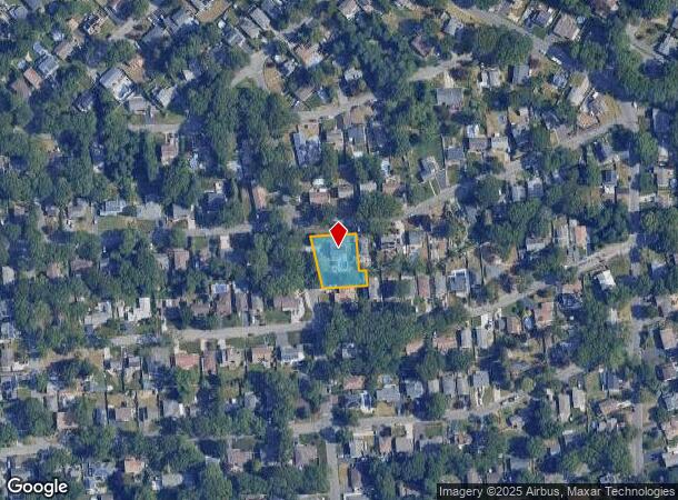
Property Record
400 Boulder St, Ronkonkoma, NY 11779
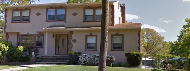
This Property Is For Sale
NEARBY LISTINGS FOR SALE OR LEASE
-
-
View all Ronkonkoma listings for sale on LoopNet.com
Property Detail
400 Boulder St
Nassau County-Suffolk County, NY
Lake Hills
0500-032-00-02-00-042-000
Suffolk
Sfr
New York
X
0.35 AC
36103C0660H
Central Suffolk
2,104 SF
Long Island (New York)
DEMOGRAPHICS near 400 Boulder St
1 Mile
3 Mile
5 Mile
2024 Total Population
14,054
81,703
220,348
2029 Population
13,813
80,440
216,952
Pop Growth 2024-2029
(1.71%)
(1.55%)
(1.54%)
Average Age
41
42
41
2024 Total Households
4,627
27,310
73,651
HH Growth 2024-2029
(1.92%)
(1.73%)
(1.66%)
Median Household Inc
$118,361
$119,526
$118,501
Avg Household Size
3.00
2.90
2.90
2024 Avg HH Vehicles
2.00
2.00
2.00
Median Home Value
$426,327
$461,768
$466,804
Median Year Built
1968
1969
1970
Nearby Places
- Restaurants
- Banks
- Shops
- Fitness
- Groceries
PUBLIC TRANSPORTATION
COMMUTER RAIL
Ronkonkoma Station (Greenport Branch - Long Island Rail Road, Ronkonkoma Branch - Long Island Rail Road)
DRIVE
WALK
Distance
Ronkonkoma Station (Greenport Branch - Long Island Rail Road, Ronkonkoma Branch - Long Island Rail Road)
6 min
2.6 mi
Central Islip Station (Ronkonkoma Branch - Long Island Rail Road)
DRIVE
WALK
Distance
Central Islip Station (Ronkonkoma Branch - Long Island Rail Road)
10 min
4.4 mi
AIRPORT
Long Island MacArthur
DRIVE
WALK
Distance
Long Island MacArthur
9 min
3.9 mi
Freight Ports
Port of New Haven
DRIVE
WALK
Distance
Port of New Haven
129 min
49.9 mi
Nearby Properties
Address
Land Use
TOTAL SIZE
Lot Size
Zoning
Address
Land Use
TOTAL SIZE
Lot Size
Zoning
1,207.60 AC
Address
Land Use
TOTAL SIZE
Lot Size
Zoning
69.90 AC
AA
Address
Land Use
TOTAL SIZE
Lot Size
Zoning
49.54 AC
CA
Address
Land Use
TOTAL SIZE
Lot Size
Zoning
8.05 AC
NULL
Address
Land Use
TOTAL SIZE
Lot Size
Zoning
170.87 AC
AAA
Address
Land Use
TOTAL SIZE
Lot Size
Zoning
36.66 AC
NULL
Address
Land Use
TOTAL SIZE
Lot Size
Zoning
51.59 AC
AA
Address
Land Use
TOTAL SIZE
Lot Size
Zoning
360.60 AC
AAA
Address
Land Use
TOTAL SIZE
Lot Size
Zoning
13.06 AC
BUS3
Address
Land Use
TOTAL SIZE
Lot Size
Zoning
18.68 AC
IND1
Address
Land Use
TOTAL SIZE
Lot Size
Zoning
97.24 AC
AAA
Address
Land Use
TOTAL SIZE
Lot Size
Zoning
12.84 AC
NULL
Address
Land Use
TOTAL SIZE
Lot Size
Zoning
23.08 AC
AA
Address
Land Use
TOTAL SIZE
Lot Size
Zoning
45.71 AC
NULL
Address
Land Use
TOTAL SIZE
Lot Size
Zoning
200.70 AC
AAA
Address
Land Use
TOTAL SIZE
Lot Size
Zoning
5.53 AC
ICD
Address
Land Use
TOTAL SIZE
Lot Size
Zoning
5.32 AC
BUS3
Address
Land Use
TOTAL SIZE
Lot Size
Zoning
6.81 AC
NULL
Address
Land Use
TOTAL SIZE
Lot Size
Zoning
152.10 AC
AA
Address
Land Use
TOTAL SIZE
Lot Size
Zoning
12.80 AC
AAA
Address
Land Use
TOTAL SIZE
Lot Size
Zoning
5.40 AC
ICD
Address
Land Use
TOTAL SIZE
Lot Size
Zoning
6.50 AC
GSE
Address
Land Use
TOTAL SIZE
Lot Size
Zoning
Address
Land Use
TOTAL SIZE
Lot Size
Zoning
15.80 AC
ICD
Address
Land Use
TOTAL SIZE
Lot Size
Zoning
12.20 AC
IND1
Address
Land Use
TOTAL SIZE
Lot Size
Zoning
10.99 AC
Address
Land Use
TOTAL SIZE
Lot Size
Zoning
11.86 AC
NULL
Address
Land Use
TOTAL SIZE
Lot Size
Zoning
7.54 AC
Address
Land Use
TOTAL SIZE
Lot Size
Zoning
60.30 AC
Address
Land Use
TOTAL SIZE
Lot Size
Zoning
12.12 AC
IND1
The World's #1 Commercial Real Estate Marketplace
Connect with us
© 2025 CoStar Group
The information above has been obtained from sources believed reliable. While we do not doubt its accuracy we have not verified it and make no guarantee, warranty or representation about it. It is your responsibility to independently confirm its accuracy and completeness. Any projections, opinions, assumptions, or estimates used are for example only and do not represent the current or future performance of the property. The value of this transaction to you depends on tax and other factors which should be evaluated by your tax, financial, and legal advisors. You and your advisors should conduct a careful, independent investigation of the property to determine to your satisfaction the suitability of the property for your needs.