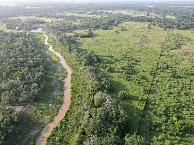
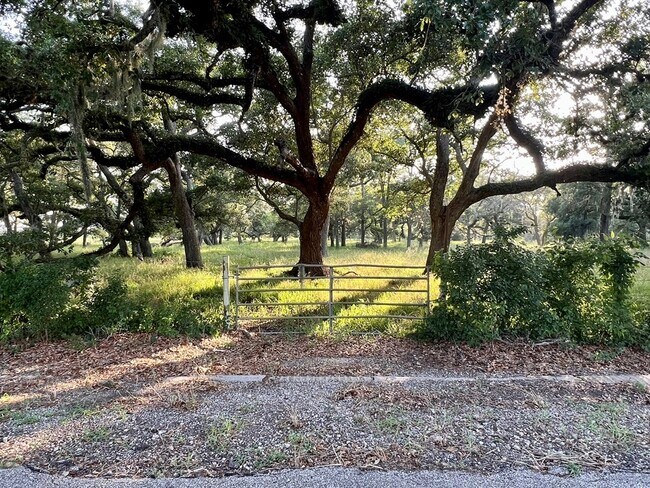
Property Record
400 Brazos River Rd, Freeport, TX 77541
Property Detail
400 Brazos River Rd
0020-1502-000
A0020 S F AUSTIN TRACT 7 (DIV 18) ACRES 19.53
Agriculturalland
BRAZORIA
0003
Texas
AE The base floodplain where base flood elevations are provided. AE Zones are now used on new format FIRMs instead of A1-A30 Zones.
7
2024
10 AC
2025
Southwest Far
664200
Houston
8,400 SF
Houston-Pasadena-The Woodlands, TX
NEARBY LISTINGS FOR SALE OR LEASE
DEMOGRAPHICS near 400 Brazos River Rd
1 mile
3 mile
5 mile
2025 Total Population
186
17,910
54,116
2030 Population
212
19,734
59,914
Pop Growth 2025-2030
+ 13.98%
+ 10.18%
+ 10.71%
Average Age
42
37
38
2025 Total Households
66
6,931
20,258
HH Growth 2025-2030
+ 13.64%
+ 10.58%
+ 11.27%
Median Household Inc
$88,815
$73,891
$79,426
Avg Household Size
2.80
2.50
2.60
2025 Avg HH Vehicles
3.00
2.00
2.00
Median Home Value
$235,714
$224,863
$240,783
Median Year Built
1993
1985
1983
Nearby Places
Map Layers
Map Styles
 Street
 Aerial
Transit
 Traffic
 Biking
Places
Listings with unknown addresses are not visible on the map
- Restaurants
- Banks
- Shops
- Fitness
- Groceries
SALE & LEASE HISTORY
LISTING DATE
SALE/LEASE

Dec 10, 2024
For Sale
Nearby Properties
Address
Land Use
TOTAL SIZE
Lot Size
Zoning
Address
Land Use
TOTAL SIZE
Lot Size
Zoning
274,303 SF
15.11 AC
0004
Address
Land Use
TOTAL SIZE
Lot Size
Zoning
167,434 SF
25 AC
Address
Land Use
TOTAL SIZE
Lot Size
Zoning
161,170 SF
8.67 AC
Address
Land Use
TOTAL SIZE
Lot Size
Zoning
253,058 SF
12.07 AC
Address
Land Use
TOTAL SIZE
Lot Size
Zoning
102,425 SF
15.42 AC
Address
Land Use
TOTAL SIZE
Lot Size
Zoning
200,113 SF
10.07 AC
0033
Address
Land Use
TOTAL SIZE
Lot Size
Zoning
200,711 SF
9.88 AC
0041
Address
Land Use
TOTAL SIZE
Lot Size
Zoning
45,667 SF
66.18 AC
8500
Address
Land Use
TOTAL SIZE
Lot Size
Zoning
120,591 SF
7.70 AC
Address
Land Use
TOTAL SIZE
Lot Size
Zoning
136,550 SF
8.97 AC
Address
Land Use
TOTAL SIZE
Lot Size
Zoning
164,368 SF
6.85 AC
Address
Land Use
TOTAL SIZE
Lot Size
Zoning
184,398 SF
11.89 AC
Address
Land Use
TOTAL SIZE
Lot Size
Zoning
135,443 SF
36.97 AC
Address
Land Use
TOTAL SIZE
Lot Size
Zoning
100,826 SF
7.20 AC
Address
Land Use
TOTAL SIZE
Lot Size
Zoning
129,286 SF
6.14 AC
Address
Land Use
TOTAL SIZE
Lot Size
Zoning
69,107 SF
10.76 AC
Address
Land Use
TOTAL SIZE
Lot Size
Zoning
155,435 SF
14.28 AC
0007
Address
Land Use
TOTAL SIZE
Lot Size
Zoning
67,517 SF
53.79 AC
Address
Land Use
TOTAL SIZE
Lot Size
Zoning
75,338 SF
6.31 AC
0034
Address
Land Use
TOTAL SIZE
Lot Size
Zoning
124,993 SF
6.36 AC
Address
Land Use
TOTAL SIZE
Lot Size
Zoning
46,269 SF
2.65 AC
Address
Land Use
TOTAL SIZE
Lot Size
Zoning
90,459 SF
4.94 AC
Address
Land Use
TOTAL SIZE
Lot Size
Zoning
34,098 SF
3.18 AC
Address
Land Use
TOTAL SIZE
Lot Size
Zoning
61,890 SF
31.63 AC
Address
Land Use
TOTAL SIZE
Lot Size
Zoning
59,261 SF
2.17 AC
Address
Land Use
TOTAL SIZE
Lot Size
Zoning
58,460 SF
5.09 AC
Address
Land Use
TOTAL SIZE
Lot Size
Zoning
46,832 SF
2.24 AC
Address
Land Use
TOTAL SIZE
Lot Size
Zoning
64,026 SF
2.50 AC
0055
Address
Land Use
TOTAL SIZE
Lot Size
Zoning
40,230 SF
3.17 AC
Address
Land Use
TOTAL SIZE
Lot Size
Zoning
17,598 SF
7.40 AC
The World's #1 Commercial Real Estate Marketplace
Connect with us
© 2026 CoStar Group
The information above has been obtained from sources believed reliable. While we do not doubt its accuracy we have not verified it and make no guarantee, warranty or representation about it. It is your responsibility to independently confirm its accuracy and completeness. Any projections, opinions, assumptions, or estimates used are for example only and do not represent the current or future performance of the property. The value of this transaction to you depends on tax and other factors which should be evaluated by your tax, financial, and legal advisors. You and your advisors should conduct a careful, independent investigation of the property to determine to your satisfaction the suitability of the property for your needs.