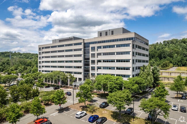
Property Record
300/400 Connell Dr, Berkeley Heights, NJ 07922
Current Lease Availabilities
NEARBY LISTINGS FOR SALE OR LEASE
Property Detail
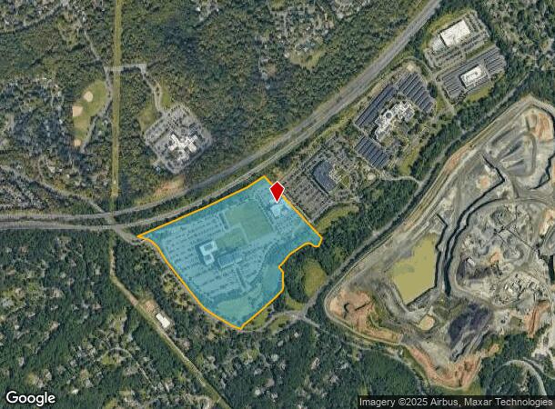
300/400 Connell Dr
01-04102-0000-00001
Union
Commercialnec
New Jersey
AE
1
34035C0091E
47.69 AC
2024
Short Hills/Millburn
2025
Northern New Jersey
038201
Newark, NJ
DEMOGRAPHICS near 300/400 Connell Dr
1 mile
3 mile
5 mile
2024 Total Population
3,790
93,529
228,665
2029 Population
3,803
92,842
226,885
Pop Growth 2024-2029
+ 0.34%
(0.73%)
(0.78%)
Average Age
43
40
40
2024 Total Households
1,221
31,507
76,279
HH Growth 2024-2029
+ 0.33%
(0.83%)
(0.85%)
Median Household Inc
$180,246
$122,859
$124,875
Avg Household Size
3.00
2.90
2.90
2024 Avg HH Vehicles
2.00
2.00
2.00
Median Home Value
$740,229
$606,316
$630,641
Median Year Built
1970
1958
1957
Nearby Places
Map Layers
Map Styles
 Street
 Aerial
Transit
 Traffic
 Biking
Places
Listings with unknown addresses are not visible on the map
- Restaurants
- Banks
- Shops
- Fitness
- Groceries
PUBLIC TRANSPORTATION
COMMUTER RAIL
Berkeley Heights (Morris & Essex Gladstone Branch - NJ Transit Commuter Rail (NJ Transit))
Drive
Walk
Distance
Berkeley Heights (Morris & Essex Gladstone Branch - NJ Transit Commuter Rail (NJ Transit))
8 min
2.4 mi
Murray Hill (Morris & Essex Gladstone Branch - NJ Transit Commuter Rail (NJ Transit))
Drive
Walk
Distance
Murray Hill (Morris & Essex Gladstone Branch - NJ Transit Commuter Rail (NJ Transit))
8 min
3.2 mi
AIRPORT
Newark Liberty International
Drive
Walk
Distance
Newark Liberty International
24 min
17.4 mi
LaGuardia
Drive
Walk
Distance
LaGuardia
58 min
36.6 mi
John F Kennedy International
Drive
Walk
Distance
John F Kennedy International
67 min
44.8 mi
Freight Ports
Maher Terminal
Drive
Walk
Distance
Maher Terminal
28 min
18.0 mi
Nearby Properties
Address
Land Use
TOTAL SIZE
Lot Size
Zoning
Address
Land Use
TOTAL SIZE
Lot Size
Zoning
151,088 SF
26.48 AC
CCRC
Address
Land Use
TOTAL SIZE
Lot Size
Zoning
20.08 AC
RML1
Address
Land Use
TOTAL SIZE
Lot Size
Zoning
153.40 AC
OR
Address
Land Use
TOTAL SIZE
Lot Size
Zoning
439.33 AC
Address
Land Use
TOTAL SIZE
Lot Size
Zoning
0.42 AC
R-1
Address
Land Use
TOTAL SIZE
Lot Size
Zoning
26.87 AC
H-D
Address
Land Use
TOTAL SIZE
Lot Size
Zoning
47.80 AC
H-D
Address
Land Use
TOTAL SIZE
Lot Size
Zoning
34.60 AC
MU
Address
Land Use
TOTAL SIZE
Lot Size
Zoning
140,732 SF
42.73 AC
OR
Address
Land Use
TOTAL SIZE
Lot Size
Zoning
15.79 AC
H-D
Address
Land Use
TOTAL SIZE
Lot Size
Zoning
24.92 AC
MU
Address
Land Use
TOTAL SIZE
Lot Size
Zoning
12.47 AC
H-D
Address
Land Use
TOTAL SIZE
Lot Size
Zoning
4.74 AC
NC
Address
Land Use
TOTAL SIZE
Lot Size
Zoning
19.84 AC
H-D
Address
Land Use
TOTAL SIZE
Lot Size
Zoning
61,912 SF
16 AC
OR
Address
Land Use
TOTAL SIZE
Lot Size
Zoning
23.66 AC
R2
Address
Land Use
TOTAL SIZE
Lot Size
Zoning
356.94 AC
OL
Address
Land Use
TOTAL SIZE
Lot Size
Zoning
21.53 AC
H-D
Address
Land Use
TOTAL SIZE
Lot Size
Zoning
36.55 AC
OL
Address
Land Use
TOTAL SIZE
Lot Size
Zoning
122,820 SF
14.65 AC
H-D
Address
Land Use
TOTAL SIZE
Lot Size
Zoning
184,000 SF
24.43 AC
OR
Address
Land Use
TOTAL SIZE
Lot Size
Zoning
120 SF
9.80 AC
Address
Land Use
TOTAL SIZE
Lot Size
Zoning
12.52 AC
H-D
Address
Land Use
TOTAL SIZE
Lot Size
Zoning
0.39 AC
R5
Address
Land Use
TOTAL SIZE
Lot Size
Zoning
28.80 AC
Address
Land Use
TOTAL SIZE
Lot Size
Zoning
6.76 AC
MU
Address
Land Use
TOTAL SIZE
Lot Size
Zoning
Address
Land Use
TOTAL SIZE
Lot Size
Zoning
87,778 SF
1.88 AC
Address
Land Use
TOTAL SIZE
Lot Size
Zoning
The World's #1 Commercial Real Estate Marketplace
Connect with us
© 2026 CoStar Group
The information above has been obtained from sources believed reliable. While we do not doubt its accuracy we have not verified it and make no guarantee, warranty or representation about it. It is your responsibility to independently confirm its accuracy and completeness. Any projections, opinions, assumptions, or estimates used are for example only and do not represent the current or future performance of the property. The value of this transaction to you depends on tax and other factors which should be evaluated by your tax, financial, and legal advisors. You and your advisors should conduct a careful, independent investigation of the property to determine to your satisfaction the suitability of the property for your needs.