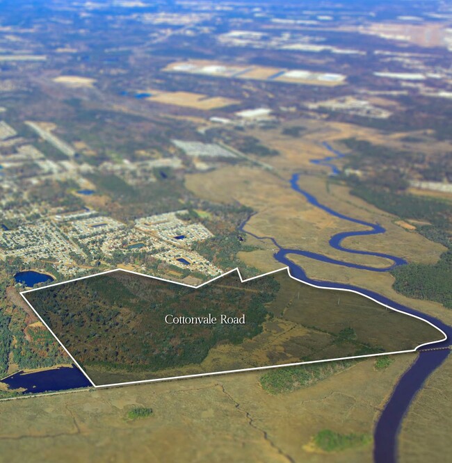
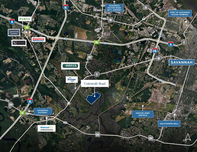
Property Record
Highway 17, Savannah, GA 31405
NEARBY LISTINGS FOR SALE OR LEASE
Property Detail
Highway 17
Savannah, GA
West Side 2
1099201017
PARCEL F LEBANON PLANTATION FAR M TRACTS 57 AC T (36 AC H & 21
Vacantlandnec
Chatham
X
Georgia
13051C0140G
57 AC
2024
Outlying Chatham County
2025
Savannah
004500
DEMOGRAPHICS near Highway 17
1 Mile
3 Mile
5 Mile
2024 Total Population
1,957
24,462
75,876
2029 Population
2,039
25,358
78,651
Pop Growth 2024-2029
+ 4.19%
+ 3.66%
+ 3.66%
Average Age
37
38
38
2024 Total Households
707
9,895
29,821
HH Growth 2024-2029
+ 4.24%
+ 3.57%
+ 3.83%
Median Household Inc
$86,405
$69,738
$59,906
Avg Household Size
2.70
2.40
2.40
2024 Avg HH Vehicles
1.00
2.00
2.00
Median Home Value
$173,928
$204,542
$190,354
Median Year Built
2006
2001
1997
Nearby Places
- Restaurants
- Banks
- Shops
- Fitness
- Groceries
PUBLIC TRANSPORTATION
COMMUTER RAIL
Savannah (Palmetto - Amtrak, Silver Meteor - Amtrak, Silver Star - Amtrak)
DRIVE
WALK
Distance
Savannah (Palmetto - Amtrak, Silver Meteor - Amtrak, Silver Star - Amtrak)
18 min
8.1 mi
AIRPORT
Savannah/Hilton Head International
DRIVE
WALK
Distance
Savannah/Hilton Head International
22 min
9.2 mi
Freight Ports
Georgia Ports - Savannah
DRIVE
WALK
Distance
Georgia Ports - Savannah
24 min
11.2 mi
Nearby Properties
Address
Land Use
TOTAL SIZE
Lot Size
Zoning
Address
Land Use
TOTAL SIZE
Lot Size
Zoning
99.50 AC
M
Address
Land Use
TOTAL SIZE
Lot Size
Zoning
70.49 AC
M
Address
Land Use
TOTAL SIZE
Lot Size
Zoning
942,210 SF
50.60 AC
Address
Land Use
TOTAL SIZE
Lot Size
Zoning
34,980 SF
23.34 AC
PR3-16
Address
Land Use
TOTAL SIZE
Lot Size
Zoning
33,510 SF
22.30 AC
PRM16
Address
Land Use
TOTAL SIZE
Lot Size
Zoning
12,560 SF
14.82 AC
PUD
Address
Land Use
TOTAL SIZE
Lot Size
Zoning
21.13 AC
PUDC
Address
Land Use
TOTAL SIZE
Lot Size
Zoning
6,580 SF
42.03 AC
PUDM-12
Address
Land Use
TOTAL SIZE
Lot Size
Zoning
413,230 SF
39.64 AC
M-CO
Address
Land Use
TOTAL SIZE
Lot Size
Zoning
8,208 SF
48.30 AC
PUDC
Address
Land Use
TOTAL SIZE
Lot Size
Zoning
355,570 SF
25.41 AC
PIL
Address
Land Use
TOTAL SIZE
Lot Size
Zoning
41,592 SF
20.47 AC
PUDC
Address
Land Use
TOTAL SIZE
Lot Size
Zoning
22,728 SF
15.81 AC
PUDC
Address
Land Use
TOTAL SIZE
Lot Size
Zoning
12,560 SF
22.94 AC
PUD
Address
Land Use
TOTAL SIZE
Lot Size
Zoning
27,168 SF
15.95 AC
PUDC
Address
Land Use
TOTAL SIZE
Lot Size
Zoning
16,138 SF
18.33 AC
PUDC
Address
Land Use
TOTAL SIZE
Lot Size
Zoning
6,278 SF
24.47 AC
RA
Address
Land Use
TOTAL SIZE
Lot Size
Zoning
27,408 SF
12.97 AC
PUDC
Address
Land Use
TOTAL SIZE
Lot Size
Zoning
28.95 AC
M
Address
Land Use
TOTAL SIZE
Lot Size
Zoning
71,502 SF
10.60 AC
PUDIS
Address
Land Use
TOTAL SIZE
Lot Size
Zoning
18,800 SF
8.71 AC
PUDC
Address
Land Use
TOTAL SIZE
Lot Size
Zoning
11,784 SF
9.79 AC
PUDC
Address
Land Use
TOTAL SIZE
Lot Size
Zoning
142,560 SF
6.67 AC
PUDCC
Address
Land Use
TOTAL SIZE
Lot Size
Zoning
35,304 SF
6.40 AC
PUDC
Address
Land Use
TOTAL SIZE
Lot Size
Zoning
35,304 SF
6.86 AC
PUDC
Address
Land Use
TOTAL SIZE
Lot Size
Zoning
11,784 SF
9.37 AC
PUDC
Address
Land Use
TOTAL SIZE
Lot Size
Zoning
13,225 SF
18.59 AC
PUDCC
Address
Land Use
TOTAL SIZE
Lot Size
Zoning
88,000 SF
9.62 AC
PIL
Address
Land Use
TOTAL SIZE
Lot Size
Zoning
79,700 SF
4.67 AC
PUDCC
Address
Land Use
TOTAL SIZE
Lot Size
Zoning
70,384 SF
8.78 AC
PUDC
The World's #1 Commercial Real Estate Marketplace
Connect with us
© 2025 CoStar Group
The information above has been obtained from sources believed reliable. While we do not doubt its accuracy we have not verified it and make no guarantee, warranty or representation about it. It is your responsibility to independently confirm its accuracy and completeness. Any projections, opinions, assumptions, or estimates used are for example only and do not represent the current or future performance of the property. The value of this transaction to you depends on tax and other factors which should be evaluated by your tax, financial, and legal advisors. You and your advisors should conduct a careful, independent investigation of the property to determine to your satisfaction the suitability of the property for your needs.