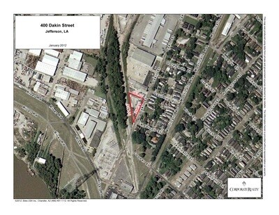
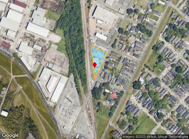
Property Record
400 Dakin St, New Orleans, LA 70121
NEARBY LISTINGS FOR SALE OR LEASE
Property Detail
400 Dakin St
New Orleans-Metairie, LA
Ludger Fortier Plant
0700004250
IN SEC 38 T 12 S R 11 E 9700931 11221792
Realpropertynec
Jefferson
X
Louisiana
22051C0185F
101
2024
0.45 AC
2024
Jefferson
024900
New Orleans/Metairie/Kenner
DEMOGRAPHICS near 400 Dakin St
1 mile
3 mile
5 mile
2024 Total Population
12,014
132,676
345,019
2029 Population
11,507
127,727
333,153
Pop Growth 2024-2029
(4.22%)
(3.73%)
(3.44%)
Average Age
42
41
42
2024 Total Households
5,691
57,966
158,496
HH Growth 2024-2029
(4.45%)
(3.94%)
(3.46%)
Median Household Inc
$51,490
$63,077
$58,069
Avg Household Size
2.00
2.10
2.10
2024 Avg HH Vehicles
1.00
1.00
1.00
Median Home Value
$305,114
$358,147
$327,422
Median Year Built
1946
1950
1959
Nearby Places
Map Layers
Map Styles
 Street
 Aerial
Transit
 Traffic
 Biking
Places
Listings with unknown addresses are not visible on the map
- Restaurants
- Banks
- Shops
- Fitness
- Groceries
PUBLIC TRANSPORTATION
TRANSIT/SUBWAY
Carrollton and Willow (St. Charles Streetcar - New Orleans Regional Transit Authority Streetcars (New Orleans Streetcars))
Drive
Walk
Distance
Carrollton and Willow (St. Charles Streetcar - New Orleans Regional Transit Authority Streetcars (New Orleans Streetcars))
2 min
15 min
0.8 mi
Carrollton and Oak (St. Charles Streetcar - New Orleans Regional Transit Authority Streetcars (New Orleans Streetcars))
Drive
Walk
Distance
Carrollton and Oak (St. Charles Streetcar - New Orleans Regional Transit Authority Streetcars (New Orleans Streetcars))
2 min
16 min
0.9 mi
Carrollton and Freret (St. Charles Streetcar - New Orleans Regional Transit Authority Streetcars (New Orleans Streetcars))
Drive
Walk
Distance
Carrollton and Freret (St. Charles Streetcar - New Orleans Regional Transit Authority Streetcars (New Orleans Streetcars))
2 min
17 min
0.9 mi
Carrollton and Birch (St. Charles Streetcar - New Orleans Regional Transit Authority Streetcars (New Orleans Streetcars))
Drive
Walk
Distance
Carrollton and Birch (St. Charles Streetcar - New Orleans Regional Transit Authority Streetcars (New Orleans Streetcars))
2 min
18 min
0.9 mi
Carrollton and Hickory (St. Charles Streetcar - New Orleans Regional Transit Authority Streetcars (New Orleans Streetcars))
Drive
Walk
Distance
Carrollton and Hickory (St. Charles Streetcar - New Orleans Regional Transit Authority Streetcars (New Orleans Streetcars))
3 min
18 min
0.9 mi
COMMUTER RAIL
Drive
Walk
Distance
11 min
5.5 mi
AIRPORT
Louis Armstrong New Orleans International
Drive
Walk
Distance
Louis Armstrong New Orleans International
22 min
12.4 mi
Freight Ports
Port of New Orleans
Drive
Walk
Distance
Port of New Orleans
17 min
7.5 mi
Nearby Properties
Address
Land Use
TOTAL SIZE
Lot Size
Zoning
Address
Land Use
TOTAL SIZE
Lot Size
Zoning
80.92 AC
EC
Address
Land Use
TOTAL SIZE
Lot Size
Zoning
22.63 AC
Address
Land Use
TOTAL SIZE
Lot Size
Zoning
468,704 SF
7.58 AC
MC
Address
Land Use
TOTAL SIZE
Lot Size
Zoning
197,182 SF
0.01 AC
OS-R
Address
Land Use
TOTAL SIZE
Lot Size
Zoning
0.14 AC
Address
Land Use
TOTAL SIZE
Lot Size
Zoning
725,677 SF
54.19 AC
EC
Address
Land Use
TOTAL SIZE
Lot Size
Zoning
609,449 SF
2 AC
EC
Address
Land Use
TOTAL SIZE
Lot Size
Zoning
1.15 AC
MS
Address
Land Use
TOTAL SIZE
Lot Size
Zoning
0.16 AC
Address
Land Use
TOTAL SIZE
Lot Size
Zoning
35.06 AC
Address
Land Use
TOTAL SIZE
Lot Size
Zoning
4.31 AC
BC2
Address
Land Use
TOTAL SIZE
Lot Size
Zoning
3.36 AC
EC
Address
Land Use
TOTAL SIZE
Lot Size
Zoning
315,570 SF
4.42 AC
HU-RM2
Address
Land Use
TOTAL SIZE
Lot Size
Zoning
2.20 AC
EC
Address
Land Use
TOTAL SIZE
Lot Size
Zoning
63.72 AC
OS-N
Address
Land Use
TOTAL SIZE
Lot Size
Zoning
0.08 AC
Address
Land Use
TOTAL SIZE
Lot Size
Zoning
Address
Land Use
TOTAL SIZE
Lot Size
Zoning
Address
Land Use
TOTAL SIZE
Lot Size
Zoning
66.97 AC
LI
Address
Land Use
TOTAL SIZE
Lot Size
Zoning
Address
Land Use
TOTAL SIZE
Lot Size
Zoning
11.29 AC
HU-RD1
Address
Land Use
TOTAL SIZE
Lot Size
Zoning
20.13 AC
EC
Address
Land Use
TOTAL SIZE
Lot Size
Zoning
Address
Land Use
TOTAL SIZE
Lot Size
Zoning
25,744 SF
14.18 AC
LI
Address
Land Use
TOTAL SIZE
Lot Size
Zoning
9.02 AC
HU-RD2
Address
Land Use
TOTAL SIZE
Lot Size
Zoning
7,468 SF
8.13 AC
HU-RD2
Address
Land Use
TOTAL SIZE
Lot Size
Zoning
39,963 SF
110.36 AC
OS-N
Address
Land Use
TOTAL SIZE
Lot Size
Zoning
1.27 AC
HU-RM1
Address
Land Use
TOTAL SIZE
Lot Size
Zoning
96,000 SF
1.85 AC
HU-RD2
Address
Land Use
TOTAL SIZE
Lot Size
Zoning
2.27 AC
HU-RD2
The World's #1 Commercial Real Estate Marketplace
Connect with us
© 2026 CoStar Group
The information above has been obtained from sources believed reliable. While we do not doubt its accuracy we have not verified it and make no guarantee, warranty or representation about it. It is your responsibility to independently confirm its accuracy and completeness. Any projections, opinions, assumptions, or estimates used are for example only and do not represent the current or future performance of the property. The value of this transaction to you depends on tax and other factors which should be evaluated by your tax, financial, and legal advisors. You and your advisors should conduct a careful, independent investigation of the property to determine to your satisfaction the suitability of the property for your needs.