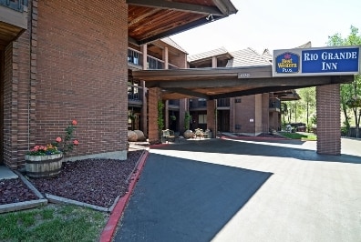
Property Record
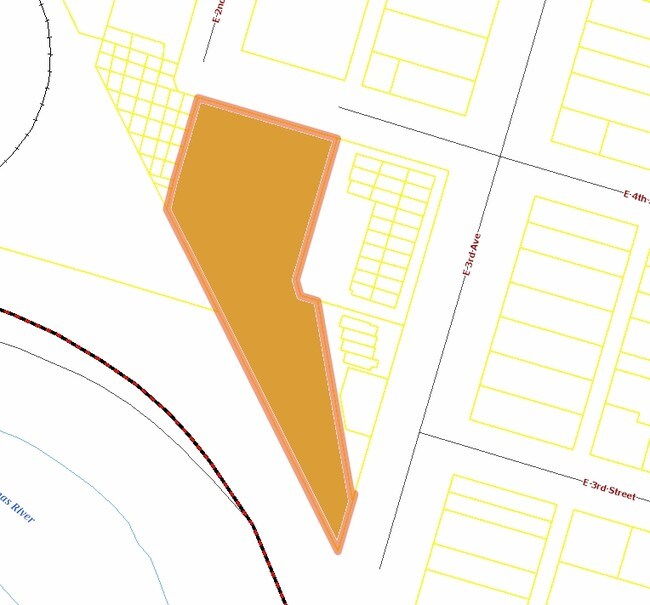
400 E 2Nd Ave, Durango, CO 81301

Property Detail
400 E 2Nd Ave
Durango, CO
SUBDIVISION: MOUNTAIN VIEW ADD BLOCK: 2 LOT: 1 MCCALLISTER INVESTMENTS LP BA & LOT CONS PLAT #870791 400 E 2ND AVE DURANGO 81301
R426040
La Plata
Transientlodging
Colorado
B and X Area of moderate flood hazard, usually the area between the limits of the 100-year and 500-year floods.
1
2024
1.73 AC
2025
Colorado Southwest Area
971100
Other Market Areas
52,704 SF
NEARBY LISTINGS FOR SALE OR LEASE
-
-
View all Durango listings for sale on LoopNet.com
DEMOGRAPHICS near 400 E 2Nd Ave
1 mile
3 mile
5 mile
2025 Total Population
3,481
16,646
23,993
2030 Population
3,479
16,642
24,040
Pop Growth 2025-2030
(0.06%)
(0.02%)
+ 0.20%
Average Age
39
39
40
2025 Total Households
1,704
6,817
10,118
HH Growth 2025-2030
(0.29%)
(0.44%)
(0.13%)
Median Household Inc
$70,595
$88,089
$89,598
Avg Household Size
2.00
2.10
2.10
2025 Avg HH Vehicles
2.00
2.00
2.00
Median Home Value
$730,769
$715,505
$714,395
Median Year Built
1957
1979
1987
Nearby Places
Map Layers
Map Styles
 Street
 Aerial
Transit
 Traffic
 Biking
Places
Listings with unknown addresses are not visible on the map
- Restaurants
- Banks
- Shops
- Fitness
- Groceries
PUBLIC TRANSPORTATION
AIRPORT
Durango-La Plata County
Drive
Walk
Distance
Durango-La Plata County
25 min
14.9 mi
Nearby Properties
Address
Land Use
TOTAL SIZE
Lot Size
Zoning
Address
Land Use
TOTAL SIZE
Lot Size
Zoning
1,237,361 SF
230.69 AC
Address
Land Use
TOTAL SIZE
Lot Size
Zoning
277,165 SF
16.47 AC
Address
Land Use
TOTAL SIZE
Lot Size
Zoning
174,631 SF
32.10 AC
Address
Land Use
TOTAL SIZE
Lot Size
Zoning
108,918 SF
27.44 AC
Address
Land Use
TOTAL SIZE
Lot Size
Zoning
68,857 SF
21.03 AC
Address
Land Use
TOTAL SIZE
Lot Size
Zoning
153,242 SF
11.62 AC
Address
Land Use
TOTAL SIZE
Lot Size
Zoning
30,443 SF
0.65 AC
Address
Land Use
TOTAL SIZE
Lot Size
Zoning
108,697 SF
13.51 AC
Address
Land Use
TOTAL SIZE
Lot Size
Zoning
112,681 SF
1.12 AC
Address
Land Use
TOTAL SIZE
Lot Size
Zoning
159,163 SF
5.50 AC
Address
Land Use
TOTAL SIZE
Lot Size
Zoning
180,591 SF
13.50 AC
Address
Land Use
TOTAL SIZE
Lot Size
Zoning
87,592 SF
10.30 AC
Address
Land Use
TOTAL SIZE
Lot Size
Zoning
48,369 SF
0.63 AC
Address
Land Use
TOTAL SIZE
Lot Size
Zoning
58,393 SF
10.20 AC
Address
Land Use
TOTAL SIZE
Lot Size
Zoning
45,824 SF
4.55 AC
Address
Land Use
TOTAL SIZE
Lot Size
Zoning
78,166 SF
6.73 AC
Address
Land Use
TOTAL SIZE
Lot Size
Zoning
51,923 SF
Address
Land Use
TOTAL SIZE
Lot Size
Zoning
45,340 SF
3.74 AC
Address
Land Use
TOTAL SIZE
Lot Size
Zoning
65,704 SF
2.27 AC
Address
Land Use
TOTAL SIZE
Lot Size
Zoning
23,667 SF
1.91 AC
Address
Land Use
TOTAL SIZE
Lot Size
Zoning
60,809 SF
3.02 AC
Address
Land Use
TOTAL SIZE
Lot Size
Zoning
51,561 SF
37.58 AC
Address
Land Use
TOTAL SIZE
Lot Size
Zoning
29,546 SF
4.14 AC
Address
Land Use
TOTAL SIZE
Lot Size
Zoning
23,503 SF
14.22 AC
Address
Land Use
TOTAL SIZE
Lot Size
Zoning
112,292 SF
9.21 AC
Address
Land Use
TOTAL SIZE
Lot Size
Zoning
45,481 SF
5 AC
Address
Land Use
TOTAL SIZE
Lot Size
Zoning
72,094 SF
0.57 AC
Address
Land Use
TOTAL SIZE
Lot Size
Zoning
48,258 SF
3.30 AC
Address
Land Use
TOTAL SIZE
Lot Size
Zoning
49,001 SF
7.61 AC
The World's #1 Commercial Real Estate Marketplace
Connect with us
© 2026 CoStar Group
The information above has been obtained from sources believed reliable. While we do not doubt its accuracy we have not verified it and make no guarantee, warranty or representation about it. It is your responsibility to independently confirm its accuracy and completeness. Any projections, opinions, assumptions, or estimates used are for example only and do not represent the current or future performance of the property. The value of this transaction to you depends on tax and other factors which should be evaluated by your tax, financial, and legal advisors. You and your advisors should conduct a careful, independent investigation of the property to determine to your satisfaction the suitability of the property for your needs.