Property Record
468 E Division St, Rockford, MI 49341
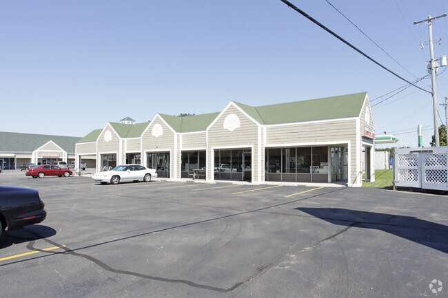

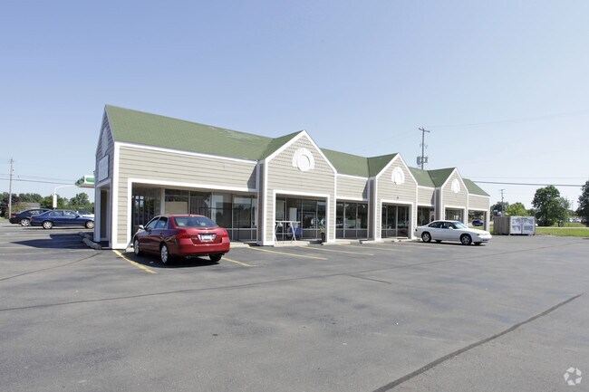
Property Detail
468 E Division St
41-11-06-101-008
THAT PART OF N 525 FT OF NWFRL 1/4 LYING WLY OF WLY LINE OF WOLVERINE BLVE /300 FT WIDE/ EX W 100 FT & EX COM 301.41 FT E
Stripcommercialcenter
KENT
C-3
Michigan
B and X Area of moderate flood hazard, usually the area between the limits of the 100-year and 500-year floods.
3.63 AC
2024
Outlying Kent County
2025
West Michigan
010803
Grand Rapids-Wyoming-Kentwood, MI
24,756 SF
NEARBY LISTINGS FOR SALE OR LEASE
DEMOGRAPHICS near 468 E Division St
1 mile
3 mile
5 mile
2025 Total Population
5,892
22,925
47,855
2030 Population
6,056
23,637
49,368
Pop Growth 2025-2030
+ 2.78%
+ 3.11%
+ 3.16%
Average Age
40
40
41
2025 Total Households
2,350
8,441
17,357
HH Growth 2025-2030
+ 2.89%
+ 3.22%
+ 3.26%
Median Household Inc
$84,305
$109,775
$112,197
Avg Household Size
2.50
2.70
2.70
2025 Avg HH Vehicles
2.00
2.00
2.00
Median Home Value
$334,521
$385,114
$389,069
Median Year Built
1990
1992
1992
Nearby Places
Map Layers
Map Styles
 Street
 Aerial
Layers
 Traffic
 Biking
Places
Listings with unknown addresses are not visible on the map
- Restaurants
- Banks
- Shops
- Fitness
- Groceries
PUBLIC TRANSPORTATION
AIRPORT
Gerald R Ford International
Drive
Walk
Distance
Gerald R Ford International
34 min
21.6 mi
SALE & LEASE HISTORY
LISTING DATE
SALE/LEASE

Oct 22, 2019
For Lease
Nearby Properties
Address
Land Use
TOTAL SIZE
Lot Size
Zoning
Address
Land Use
TOTAL SIZE
Lot Size
Zoning
32.53 AC
Address
Land Use
TOTAL SIZE
Lot Size
Zoning
178,942 SF
143.48 AC
I-1
Address
Land Use
TOTAL SIZE
Lot Size
Zoning
178,942 SF
202.41 AC
I-1
Address
Land Use
TOTAL SIZE
Lot Size
Zoning
22.40 AC
Address
Land Use
TOTAL SIZE
Lot Size
Zoning
128,148 SF
42.93 AC
PUD
Address
Land Use
TOTAL SIZE
Lot Size
Zoning
17.30 AC
Address
Land Use
TOTAL SIZE
Lot Size
Zoning
4.51 AC
Address
Land Use
TOTAL SIZE
Lot Size
Zoning
49.13 AC
Address
Land Use
TOTAL SIZE
Lot Size
Zoning
99.87 AC
R4
Address
Land Use
TOTAL SIZE
Lot Size
Zoning
305,350 SF
49.86 AC
I-1
Address
Land Use
TOTAL SIZE
Lot Size
Zoning
113,165 SF
10.94 AC
R-3
Address
Land Use
TOTAL SIZE
Lot Size
Zoning
74,756 SF
9.86 AC
C-3
Address
Land Use
TOTAL SIZE
Lot Size
Zoning
79.34 AC
Address
Land Use
TOTAL SIZE
Lot Size
Zoning
9.88 AC
Address
Land Use
TOTAL SIZE
Lot Size
Zoning
10.08 AC
Address
Land Use
TOTAL SIZE
Lot Size
Zoning
101,815 SF
9.23 AC
C-3
Address
Land Use
TOTAL SIZE
Lot Size
Zoning
121,183 SF
6.83 AC
I-1
Address
Land Use
TOTAL SIZE
Lot Size
Zoning
8.20 AC
R-3
Address
Land Use
TOTAL SIZE
Lot Size
Zoning
10.12 AC
Address
Land Use
TOTAL SIZE
Lot Size
Zoning
6.51 AC
Address
Land Use
TOTAL SIZE
Lot Size
Zoning
10.61 AC
Address
Land Use
TOTAL SIZE
Lot Size
Zoning
44.69 AC
Address
Land Use
TOTAL SIZE
Lot Size
Zoning
64,075 SF
11.13 AC
I-1
Address
Land Use
TOTAL SIZE
Lot Size
Zoning
18,630 SF
1.84 AC
C2
Address
Land Use
TOTAL SIZE
Lot Size
Zoning
Address
Land Use
TOTAL SIZE
Lot Size
Zoning
1,725 SF
4.90 AC
R-3
Address
Land Use
TOTAL SIZE
Lot Size
Zoning
2.28 AC
Address
Land Use
TOTAL SIZE
Lot Size
Zoning
Address
Land Use
TOTAL SIZE
Lot Size
Zoning
66,590 SF
4.06 AC
I-1
Address
Land Use
TOTAL SIZE
Lot Size
Zoning
The World's #1 Commercial Real Estate Marketplace
Connect with us
© 2026 CoStar Group
The information above has been obtained from sources believed reliable. While we do not doubt its accuracy we have not verified it and make no guarantee, warranty or representation about it. It is your responsibility to independently confirm its accuracy and completeness. Any projections, opinions, assumptions, or estimates used are for example only and do not represent the current or future performance of the property. The value of this transaction to you depends on tax and other factors which should be evaluated by your tax, financial, and legal advisors. You and your advisors should conduct a careful, independent investigation of the property to determine to your satisfaction the suitability of the property for your needs.