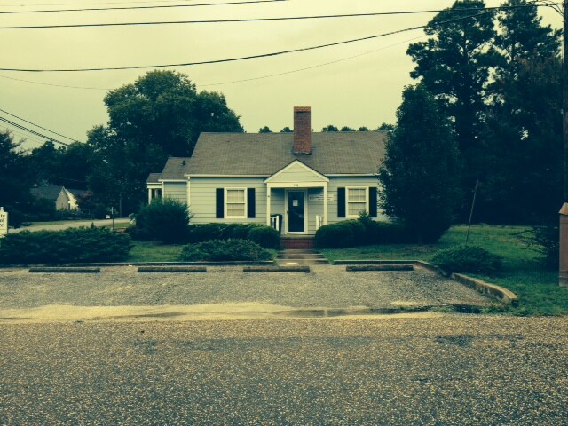
Property Record
400 E H St, Erwin, NC 28339

Property Detail
400 E H St
06059711210011
1 LT 400 EAST H NORTH 10 TH ST 88X148
Realpropertynec
Harnett
CB
North Carolina
B and X Area of moderate flood hazard, usually the area between the limits of the 100-year and 500-year floods.
400
2025
0.30 AC
2025
North Carolina Southeast Area
070500
Other Market Areas
2,829 SF
Anderson Creek, NC
NEARBY LISTINGS FOR SALE OR LEASE
DEMOGRAPHICS near 400 E H St
1 mile
3 mile
5 mile
2025 Total Population
4,049
10,333
22,758
2030 Population
4,402
11,252
24,824
Pop Growth 2025-2030
+ 8.72%
+ 8.89%
+ 9.08%
Average Age
42
43
42
2025 Total Households
1,618
4,175
9,314
HH Growth 2025-2030
+ 8.59%
+ 8.77%
+ 8.96%
Median Household Inc
$55,833
$54,640
$51,203
Avg Household Size
2.40
2.40
2.40
2025 Avg HH Vehicles
2.00
2.00
2.00
Median Home Value
$169,623
$214,646
$222,355
Median Year Built
1965
1975
1976
Nearby Places
Map Layers
Map Styles
 Street
 Aerial
Transit
 Traffic
 Biking
Places
Listings with unknown addresses are not visible on the map
- Restaurants
- Banks
- Shops
- Fitness
- Groceries
PUBLIC TRANSPORTATION
AIRPORT
Fayetteville Regional/Grannis Field
Drive
Walk
Distance
Fayetteville Regional/Grannis Field
38 min
36.9 mi
Freight Ports
Port of Wilmington
Drive
Walk
Distance
Port of Wilmington
1 min
88.4 mi
SALE & LEASE HISTORY
LISTING DATE
SALE/LEASE

Sep 23, 2016
For Sale
Aug 09, 2018
For Lease
Apr 06, 2017
For Sale
Nearby Properties
Address
Land Use
TOTAL SIZE
Lot Size
Zoning
Address
Land Use
TOTAL SIZE
Lot Size
Zoning
73.86 AC
Address
Land Use
TOTAL SIZE
Lot Size
Zoning
15.37 AC
R10
Address
Land Use
TOTAL SIZE
Lot Size
Zoning
292,616 SF
49.62 AC
M1
Address
Land Use
TOTAL SIZE
Lot Size
Zoning
81,250 SF
12.60 AC
I10
Address
Land Use
TOTAL SIZE
Lot Size
Zoning
14,466 SF
1.64 AC
Address
Land Use
TOTAL SIZE
Lot Size
Zoning
52,334 SF
8.72 AC
R10
Address
Land Use
TOTAL SIZE
Lot Size
Zoning
27.93 AC
Address
Land Use
TOTAL SIZE
Lot Size
Zoning
11,896 SF
1.61 AC
B2
Address
Land Use
TOTAL SIZE
Lot Size
Zoning
43,834 SF
3.07 AC
R10
Address
Land Use
TOTAL SIZE
Lot Size
Zoning
50,991 SF
12 AC
I10
Address
Land Use
TOTAL SIZE
Lot Size
Zoning
60,864 SF
6.33 AC
C2
Address
Land Use
TOTAL SIZE
Lot Size
Zoning
8,760 SF
2.58 AC
CB
Address
Land Use
TOTAL SIZE
Lot Size
Zoning
9,095 SF
3.12 AC
OI
Address
Land Use
TOTAL SIZE
Lot Size
Zoning
44,556 SF
2.76 AC
C2
Address
Land Use
TOTAL SIZE
Lot Size
Zoning
5,832 SF
0.63 AC
C3
Address
Land Use
TOTAL SIZE
Lot Size
Zoning
40,806 SF
5.50 AC
RM
Address
Land Use
TOTAL SIZE
Lot Size
Zoning
143,622 SF
8 AC
I10
Address
Land Use
TOTAL SIZE
Lot Size
Zoning
3,711 SF
1.50 AC
C3
Address
Land Use
TOTAL SIZE
Lot Size
Zoning
19,158 SF
5 AC
OI
Address
Land Use
TOTAL SIZE
Lot Size
Zoning
21,200 SF
4.86 AC
Address
Land Use
TOTAL SIZE
Lot Size
Zoning
16,000 SF
1.53 AC
B2
Address
Land Use
TOTAL SIZE
Lot Size
Zoning
3,274 SF
1.20 AC
C3
Address
Land Use
TOTAL SIZE
Lot Size
Zoning
17,132 SF
1.98 AC
Address
Land Use
TOTAL SIZE
Lot Size
Zoning
43,434 SF
1.87 AC
C2
Address
Land Use
TOTAL SIZE
Lot Size
Zoning
2,459 SF
1.06 AC
C3
Address
Land Use
TOTAL SIZE
Lot Size
Zoning
17,557 SF
27.88 AC
RD
Address
Land Use
TOTAL SIZE
Lot Size
Zoning
9,204 SF
9.64 AC
RA30
Address
Land Use
TOTAL SIZE
Lot Size
Zoning
3,546 SF
1.45 AC
B2
Address
Land Use
TOTAL SIZE
Lot Size
Zoning
11,735 SF
3.07 AC
R10
Address
Land Use
TOTAL SIZE
Lot Size
Zoning
2,471 SF
1.14 AC
C3
The World's #1 Commercial Real Estate Marketplace
Connect with us
© 2026 CoStar Group
The information above has been obtained from sources believed reliable. While we do not doubt its accuracy we have not verified it and make no guarantee, warranty or representation about it. It is your responsibility to independently confirm its accuracy and completeness. Any projections, opinions, assumptions, or estimates used are for example only and do not represent the current or future performance of the property. The value of this transaction to you depends on tax and other factors which should be evaluated by your tax, financial, and legal advisors. You and your advisors should conduct a careful, independent investigation of the property to determine to your satisfaction the suitability of the property for your needs.