Property Record
400 E New Bern Rd, Kinston, NC 28504
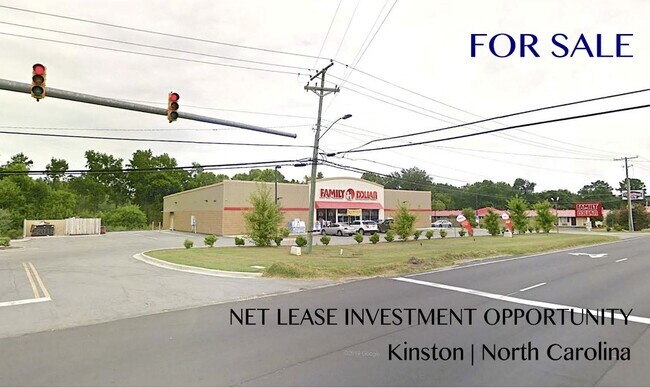

Property Detail
400 E New Bern Rd
452410464197
400 E NEW BERN RD FAMILY DOLLAR 2 LOTS SOLD 118K EACH
Wholesaleoutletdiscountstore
Lenoir
B1
North Carolina
AE The base floodplain where base flood elevations are provided. AE Zones are now used on new format FIRMs instead of A1-A30 Zones.
1.51 AC
2025
North Carolina Southeast Area
2025
Other Market Areas
011400
Kinston, NC
8,470 SF
NEARBY LISTINGS FOR SALE OR LEASE
DEMOGRAPHICS near 400 E New Bern Rd
1 mile
3 mile
5 mile
2025 Total Population
952
15,144
26,095
2030 Population
1,006
15,621
26,620
Pop Growth 2025-2030
+ 5.67%
+ 3.15%
+ 2.01%
Average Age
34
42
43
2025 Total Households
399
6,712
11,270
HH Growth 2025-2030
+ 5.51%
+ 3.22%
+ 2.09%
Median Household Inc
$30,250
$33,658
$39,527
Avg Household Size
2.40
2.20
2.20
2025 Avg HH Vehicles
1.00
1.00
2.00
Median Home Value
$145,454
$96,147
$121,957
Median Year Built
1968
1965
1970
Nearby Places
Map Layers
Map Styles
 Street
 Aerial
Layers
 Traffic
 Biking
Places
Listings with unknown addresses are not visible on the map
- Restaurants
- Banks
- Shops
- Fitness
- Groceries
PUBLIC TRANSPORTATION
AIRPORT
Pitt-Greenville
Drive
Walk
Distance
Pitt-Greenville
48 min
32.0 mi
Albert J Ellis
Drive
Walk
Distance
Albert J Ellis
60 min
34.2 mi
Coastal Carolina Regional
Drive
Walk
Distance
Coastal Carolina Regional
47 min
36.8 mi
SALE & LEASE HISTORY
LISTING DATE
SALE/LEASE

Aug 09, 2021
For Sale
Nearby Properties
Address
Land Use
TOTAL SIZE
Lot Size
Zoning
Address
Land Use
TOTAL SIZE
Lot Size
Zoning
107,460 SF
17.70 AC
I2
Address
Land Use
TOTAL SIZE
Lot Size
Zoning
20,042 SF
77.79 AC
O&I
Address
Land Use
TOTAL SIZE
Lot Size
Zoning
144,099 SF
23.48 AC
RA8
Address
Land Use
TOTAL SIZE
Lot Size
Zoning
525,504 SF
76.02 AC
I1
Address
Land Use
TOTAL SIZE
Lot Size
Zoning
77,100 SF
1.91 AC
B2
Address
Land Use
TOTAL SIZE
Lot Size
Zoning
119,634 SF
1.86 AC
B2
Address
Land Use
TOTAL SIZE
Lot Size
Zoning
51,934 SF
0.32 AC
B2
Address
Land Use
TOTAL SIZE
Lot Size
Zoning
53,768 SF
33.29 AC
I1
Address
Land Use
TOTAL SIZE
Lot Size
Zoning
73,800 SF
5.38 AC
B1
Address
Land Use
TOTAL SIZE
Lot Size
Zoning
23,086 SF
7.39 AC
RA5
Address
Land Use
TOTAL SIZE
Lot Size
Zoning
424,443 SF
104.04 AC
SC
Address
Land Use
TOTAL SIZE
Lot Size
Zoning
6,178 SF
6.33 AC
RA5
Address
Land Use
TOTAL SIZE
Lot Size
Zoning
108,816 SF
1.30 AC
B2
Address
Land Use
TOTAL SIZE
Lot Size
Zoning
13,257 SF
27.42 AC
Address
Land Use
TOTAL SIZE
Lot Size
Zoning
8,640 SF
8.03 AC
RA5
Address
Land Use
TOTAL SIZE
Lot Size
Zoning
83,088 SF
1.19 AC
B2
Address
Land Use
TOTAL SIZE
Lot Size
Zoning
3,724 SF
8.84 AC
RA5
Address
Land Use
TOTAL SIZE
Lot Size
Zoning
51,828 SF
7.05 AC
O&I
Address
Land Use
TOTAL SIZE
Lot Size
Zoning
6,760 SF
147.39 AC
RA6
Address
Land Use
TOTAL SIZE
Lot Size
Zoning
43,545 SF
5.62 AC
SC
Address
Land Use
TOTAL SIZE
Lot Size
Zoning
14,651 SF
2.85 AC
B1
Address
Land Use
TOTAL SIZE
Lot Size
Zoning
136,368 SF
11.60 AC
I1
Address
Land Use
TOTAL SIZE
Lot Size
Zoning
22,124 SF
Address
Land Use
TOTAL SIZE
Lot Size
Zoning
8,680 SF
12.35 AC
RA5
Address
Land Use
TOTAL SIZE
Lot Size
Zoning
74,734 SF
8.81 AC
RA8
Address
Land Use
TOTAL SIZE
Lot Size
Zoning
29,108 SF
88.62 AC
RA6
Address
Land Use
TOTAL SIZE
Lot Size
Zoning
10,171 SF
478.12 AC
RA8
Address
Land Use
TOTAL SIZE
Lot Size
Zoning
112,564 SF
29.12 AC
I1
Address
Land Use
TOTAL SIZE
Lot Size
Zoning
162,825 SF
19.02 AC
I1
Address
Land Use
TOTAL SIZE
Lot Size
Zoning
12,000 SF
16.02 AC
I2
The World's #1 Commercial Real Estate Marketplace
Connect with us
© 2026 CoStar Group
The information above has been obtained from sources believed reliable. While we do not doubt its accuracy we have not verified it and make no guarantee, warranty or representation about it. It is your responsibility to independently confirm its accuracy and completeness. Any projections, opinions, assumptions, or estimates used are for example only and do not represent the current or future performance of the property. The value of this transaction to you depends on tax and other factors which should be evaluated by your tax, financial, and legal advisors. You and your advisors should conduct a careful, independent investigation of the property to determine to your satisfaction the suitability of the property for your needs.