Property Record
400 E Tryon Rd, Raleigh, NC 27610
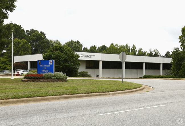
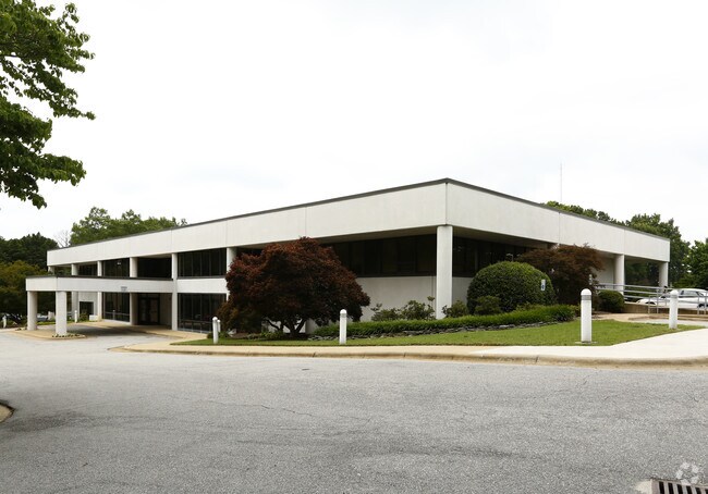
Property Detail
400 E Tryon Rd
Raleigh-Cary, NC
WAKE
1702.20-81-2547-000
North Carolina
Warehouse
128.17 AC
OX-3
Southeast Wake County
B and X Area of moderate flood hazard, usually the area between the limits of the 100-year and 500-year floods.
Raleigh/Durham
235,588 SF
NEARBY LISTINGS FOR SALE OR LEASE
DEMOGRAPHICS near 400 E Tryon Rd
1 mile
3 mile
5 mile
2025 Total Population
6,764
65,695
186,465
2030 Population
7,358
70,951
202,304
Pop Growth 2025-2030
+ 8.78%
+ 8.00%
+ 8.49%
Average Age
37
38
36
2025 Total Households
2,313
24,131
73,593
HH Growth 2025-2030
+ 9.21%
+ 8.56%
+ 9.31%
Median Household Inc
$55,082
$63,469
$70,827
Avg Household Size
2.80
2.50
2.30
2025 Avg HH Vehicles
2.00
2.00
2.00
Median Home Value
$236,524
$321,968
$376,869
Median Year Built
1993
1990
1995
Nearby Places
Map Layers
Map Styles
 Street
 Aerial
Layers
 Traffic
 Biking
Places
Listings with unknown addresses are not visible on the map
- Restaurants
- Banks
- Shops
- Fitness
- Groceries
PUBLIC TRANSPORTATION
COMMUTER RAIL
Raleigh Union Station (Piedmont - North Carolina by Train (NC Train))
Drive
Walk
Distance
Raleigh Union Station (Piedmont - North Carolina by Train (NC Train))
10 min
4.3 mi
AIRPORT
Raleigh-Durham International
Drive
Walk
Distance
Raleigh-Durham International
28 min
18.1 mi
Freight Ports
Port of Wilmington
Drive
Walk
Distance
Port of Wilmington
152 min
129.3 mi
Nearby Properties
Address
Land Use
TOTAL SIZE
Lot Size
Zoning
Address
Land Use
TOTAL SIZE
Lot Size
Zoning
972,279 SF
4.05 AC
DX-20
Address
Land Use
TOTAL SIZE
Lot Size
Zoning
458,830 SF
3.98 AC
DX-20
Address
Land Use
TOTAL SIZE
Lot Size
Zoning
2,583,746 SF
87.16 AC
HI
Address
Land Use
TOTAL SIZE
Lot Size
Zoning
573,338 SF
19.34 AC
IH
Address
Land Use
TOTAL SIZE
Lot Size
Zoning
982,323 SF
154.02 AC
OX-7
Address
Land Use
TOTAL SIZE
Lot Size
Zoning
127,409 SF
734.31 AC
R-1
Address
Land Use
TOTAL SIZE
Lot Size
Zoning
344,814 SF
1.95 AC
DX-40
Address
Land Use
TOTAL SIZE
Lot Size
Zoning
561,966 SF
3.81 AC
IX-7
Address
Land Use
TOTAL SIZE
Lot Size
Zoning
765,252 SF
1.72 AC
DX-20
Address
Land Use
TOTAL SIZE
Lot Size
Zoning
376,902 SF
189.85 AC
OX-3
Address
Land Use
TOTAL SIZE
Lot Size
Zoning
197,029 SF
6.27 AC
DX-5
Address
Land Use
TOTAL SIZE
Lot Size
Zoning
483,677 SF
1.13 AC
DX-20
Address
Land Use
TOTAL SIZE
Lot Size
Zoning
447,294 SF
5.64 AC
PD
Address
Land Use
TOTAL SIZE
Lot Size
Zoning
287,483 SF
1.95 AC
DX-40
Address
Land Use
TOTAL SIZE
Lot Size
Zoning
152,838 SF
8.88 AC
DX-30
Address
Land Use
TOTAL SIZE
Lot Size
Zoning
337,314 SF
2.01 AC
DX-20
Address
Land Use
TOTAL SIZE
Lot Size
Zoning
327,776 SF
14.48 AC
CX-5
Address
Land Use
TOTAL SIZE
Lot Size
Zoning
347,818 SF
32.02 AC
CX-3
Address
Land Use
TOTAL SIZE
Lot Size
Zoning
276,300 SF
0.99 AC
DX-40
Address
Land Use
TOTAL SIZE
Lot Size
Zoning
332,928 SF
DX-40
Address
Land Use
TOTAL SIZE
Lot Size
Zoning
395,760 SF
0.55 AC
DX-40
Address
Land Use
TOTAL SIZE
Lot Size
Zoning
332,913 SF
0.73 AC
DX-20
Address
Land Use
TOTAL SIZE
Lot Size
Zoning
490,100 SF
0.55 AC
DX-40
Address
Land Use
TOTAL SIZE
Lot Size
Zoning
108,480 SF
3.98 AC
OX-3
Address
Land Use
TOTAL SIZE
Lot Size
Zoning
28,314 SF
4.07 AC
DX-20
Address
Land Use
TOTAL SIZE
Lot Size
Zoning
454,561 SF
1.28 AC
DX-40
Address
Land Use
TOTAL SIZE
Lot Size
Zoning
151,056 SF
0.52 AC
DX-20
Address
Land Use
TOTAL SIZE
Lot Size
Zoning
370,651 SF
24.83 AC
IX-3
Address
Land Use
TOTAL SIZE
Lot Size
Zoning
249,480 SF
0.64 AC
DX-40
The World's #1 Commercial Real Estate Marketplace
Connect with us
© 2026 CoStar Group
The information above has been obtained from sources believed reliable. While we do not doubt its accuracy we have not verified it and make no guarantee, warranty or representation about it. It is your responsibility to independently confirm its accuracy and completeness. Any projections, opinions, assumptions, or estimates used are for example only and do not represent the current or future performance of the property. The value of this transaction to you depends on tax and other factors which should be evaluated by your tax, financial, and legal advisors. You and your advisors should conduct a careful, independent investigation of the property to determine to your satisfaction the suitability of the property for your needs.