Property Record
E Washington St, La Grange, NC 28551
This Property Is For Sale
NEARBY LISTINGS FOR SALE OR LEASE
-
-
View all La Grange listings for sale on LoopNet.com
Property Detail
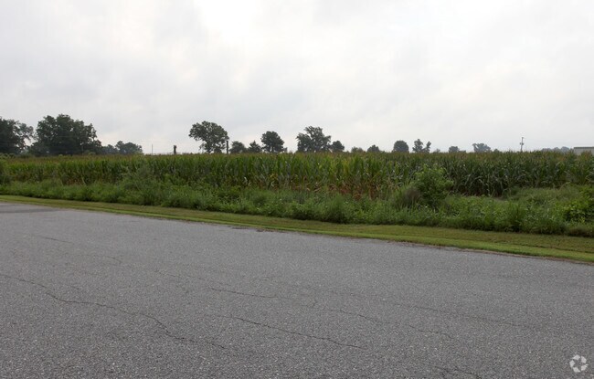
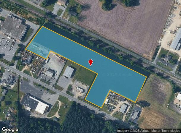
E Washington St
Kinston, NC
Recombination Survey For Simon Ray Foss
356610460938
E WASHINGTON ST
Vacantlandnec
Lenoir
X
North Carolina
3720356600K
8.55 AC
2025
North Carolina Southeast Area
2025
Other Market Areas
011100
DEMOGRAPHICS near E Washington St
1 Mile
3 Mile
5 Mile
2024 Total Population
2,401
5,267
9,982
2029 Population
2,384
5,231
9,872
Pop Growth 2024-2029
(0.71%)
(0.68%)
(1.10%)
Average Age
42
42
41
2024 Total Households
1,002
2,167
4,041
HH Growth 2024-2029
(0.80%)
(0.69%)
(1.14%)
Median Household Inc
$52,647
$42,652
$50,141
Avg Household Size
2.30
2.30
2.40
2024 Avg HH Vehicles
2.00
2.00
2.00
Median Home Value
$90,416
$91,895
$138,995
Median Year Built
1986
1987
1987
Nearby Places
Map Layers
Map Styles
 Street
 Aerial
- Restaurants
- Banks
- Shops
- Fitness
- Groceries
Nearby Properties
Address
Land Use
TOTAL SIZE
Lot Size
Zoning
Address
Land Use
TOTAL SIZE
Lot Size
Zoning
117,948 SF
8.66 AC
R10
Address
Land Use
TOTAL SIZE
Lot Size
Zoning
44,000 SF
117 AC
Address
Land Use
TOTAL SIZE
Lot Size
Zoning
134,772 SF
20.62 AC
Address
Land Use
TOTAL SIZE
Lot Size
Zoning
45,007 SF
4.39 AC
HC
Address
Land Use
TOTAL SIZE
Lot Size
Zoning
10,772 SF
10.41 AC
Address
Land Use
TOTAL SIZE
Lot Size
Zoning
9,668 SF
7.68 AC
R18
Address
Land Use
TOTAL SIZE
Lot Size
Zoning
12,672 SF
2.26 AC
Address
Land Use
TOTAL SIZE
Lot Size
Zoning
10,136 SF
47.01 AC
Address
Land Use
TOTAL SIZE
Lot Size
Zoning
3,999 SF
17.76 AC
R12
Address
Land Use
TOTAL SIZE
Lot Size
Zoning
3,867 SF
1.74 AC
Address
Land Use
TOTAL SIZE
Lot Size
Zoning
7,448 SF
9.60 AC
R18
Address
Land Use
TOTAL SIZE
Lot Size
Zoning
550.35 AC
Address
Land Use
TOTAL SIZE
Lot Size
Zoning
1,024 SF
523.54 AC
Address
Land Use
TOTAL SIZE
Lot Size
Zoning
40,078 SF
9.11 AC
OH
Address
Land Use
TOTAL SIZE
Lot Size
Zoning
13,860 SF
34.92 AC
Address
Land Use
TOTAL SIZE
Lot Size
Zoning
4,400 SF
1,145.28 AC
Address
Land Use
TOTAL SIZE
Lot Size
Zoning
16,575 SF
2.71 AC
R10
Address
Land Use
TOTAL SIZE
Lot Size
Zoning
15,880 SF
3.32 AC
Address
Land Use
TOTAL SIZE
Lot Size
Zoning
16,090 SF
7.73 AC
Address
Land Use
TOTAL SIZE
Lot Size
Zoning
5,358 SF
7.20 AC
R12
Address
Land Use
TOTAL SIZE
Lot Size
Zoning
73.80 AC
Address
Land Use
TOTAL SIZE
Lot Size
Zoning
8,000 SF
1.26 AC
Address
Land Use
TOTAL SIZE
Lot Size
Zoning
3,000 SF
224.30 AC
Address
Land Use
TOTAL SIZE
Lot Size
Zoning
4,704 SF
4.83 AC
R12
Address
Land Use
TOTAL SIZE
Lot Size
Zoning
10,000 SF
0.93 AC
DC
Address
Land Use
TOTAL SIZE
Lot Size
Zoning
13,744 SF
4.27 AC
Address
Land Use
TOTAL SIZE
Lot Size
Zoning
7,286 SF
3.67 AC
Address
Land Use
TOTAL SIZE
Lot Size
Zoning
7,674 SF
13.73 AC
Address
Land Use
TOTAL SIZE
Lot Size
Zoning
2,015 SF
7.14 AC
R10
Address
Land Use
TOTAL SIZE
Lot Size
Zoning
8,050 SF
1.19 AC
R12
The World's #1 Commercial Real Estate Marketplace
Connect with us
© 2025 CoStar Group
The information above has been obtained from sources believed reliable. While we do not doubt its accuracy we have not verified it and make no guarantee, warranty or representation about it. It is your responsibility to independently confirm its accuracy and completeness. Any projections, opinions, assumptions, or estimates used are for example only and do not represent the current or future performance of the property. The value of this transaction to you depends on tax and other factors which should be evaluated by your tax, financial, and legal advisors. You and your advisors should conduct a careful, independent investigation of the property to determine to your satisfaction the suitability of the property for your needs.