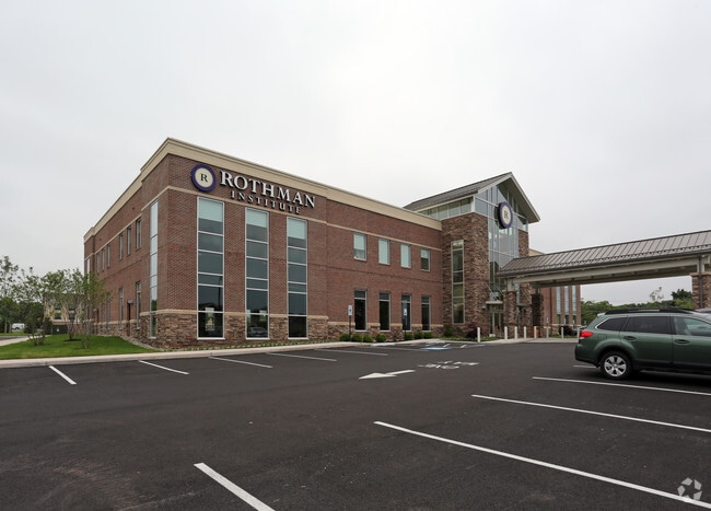
Property Record
400 Enterprise Dr, Royersford, PA 19468


NEARBY LISTINGS FOR SALE OR LEASE
Property Detail
400 Enterprise Dr
Philadelphia-Camden-Wilmington, PA-NJ-DE-MD
Linfield Corporate Center
37-00-00659-924
INCLUDES UNITS 50 & 80
Medicalbuilding
Montgomery
X
Pennsylvania
42029C0025G
49
2024
3.43 AC
2025
West Montgomery County
208603
Philadelphia
33,488 SF
DEMOGRAPHICS near 400 Enterprise Dr
1 Mile
3 Mile
5 Mile
2024 Total Population
3,509
37,459
94,203
2029 Population
3,572
38,515
96,633
Pop Growth 2024-2029
+ 1.80%
+ 2.82%
+ 2.58%
Average Age
40
41
40
2024 Total Households
1,277
15,049
35,095
HH Growth 2024-2029
+ 1.80%
+ 2.86%
+ 2.67%
Median Household Inc
$123,194
$89,175
$100,487
Avg Household Size
2.70
2.40
2.60
2024 Avg HH Vehicles
2.00
2.00
2.00
Median Home Value
$350,696
$295,905
$328,669
Median Year Built
1994
1988
1986
Nearby Places
Map Layers
Map Styles
 Street
 Aerial
- Restaurants
- Banks
- Shops
- Fitness
- Groceries
PUBLIC TRANSPORTATION
AIRPORT
Lehigh Valley International
DRIVE
WALK
Distance
Lehigh Valley International
69 min
37.8 mi
Philadelphia International
DRIVE
WALK
Distance
Philadelphia International
62 min
40.9 mi
Freight Ports
South Jersey Port
DRIVE
WALK
Distance
South Jersey Port
56 min
37.0 mi
Nearby Properties
Address
Land Use
TOTAL SIZE
Lot Size
Zoning
Address
Land Use
TOTAL SIZE
Lot Size
Zoning
605,161 SF
78.08 AC
LLI
Address
Land Use
TOTAL SIZE
Lot Size
Zoning
208,637 SF
13.37 AC
AG
Address
Land Use
TOTAL SIZE
Lot Size
Zoning
463,481 SF
79.65 AC
R1
Address
Land Use
TOTAL SIZE
Lot Size
Zoning
416,228 SF
18.24 AC
R3
Address
Land Use
TOTAL SIZE
Lot Size
Zoning
368,083 SF
126.15 AC
R2
Address
Land Use
TOTAL SIZE
Lot Size
Zoning
217,154 SF
77.97 AC
R1
Address
Land Use
TOTAL SIZE
Lot Size
Zoning
1,298,806 SF
305.46 AC
HI
Address
Land Use
TOTAL SIZE
Lot Size
Zoning
268,366 SF
32.55 AC
R4
Address
Land Use
TOTAL SIZE
Lot Size
Zoning
271,556 SF
38.87 AC
R4
Address
Land Use
TOTAL SIZE
Lot Size
Zoning
316,623 SF
15.26 AC
R4
Address
Land Use
TOTAL SIZE
Lot Size
Zoning
407,301 SF
8.04 AC
ARU
Address
Land Use
TOTAL SIZE
Lot Size
Zoning
233,630 SF
15 AC
R4
Address
Land Use
TOTAL SIZE
Lot Size
Zoning
185,077 SF
6.10 AC
MS
Address
Land Use
TOTAL SIZE
Lot Size
Zoning
125,788 SF
24.83 AC
R1
Address
Land Use
TOTAL SIZE
Lot Size
Zoning
152,928 SF
20.28 AC
R1
Address
Land Use
TOTAL SIZE
Lot Size
Zoning
103,819 SF
33 AC
R1
Address
Land Use
TOTAL SIZE
Lot Size
Zoning
124,079 SF
16.92 AC
MS
Address
Land Use
TOTAL SIZE
Lot Size
Zoning
97,188 SF
13.13 AC
OLI
Address
Land Use
TOTAL SIZE
Lot Size
Zoning
134,334 SF
21.95 AC
RB
Address
Land Use
TOTAL SIZE
Lot Size
Zoning
68,378 SF
27 AC
R3
Address
Land Use
TOTAL SIZE
Lot Size
Zoning
137,596 SF
41 AC
IN
Address
Land Use
TOTAL SIZE
Lot Size
Zoning
147,444 SF
16.09 AC
LLI
Address
Land Use
TOTAL SIZE
Lot Size
Zoning
82,802 SF
29.01 AC
R1
Address
Land Use
TOTAL SIZE
Lot Size
Zoning
98,208 SF
2.26 AC
CRSC
Address
Land Use
TOTAL SIZE
Lot Size
Zoning
214,914 SF
48.17 AC
OLI
Address
Land Use
TOTAL SIZE
Lot Size
Zoning
222,272 SF
21.60 AC
OLI
Address
Land Use
TOTAL SIZE
Lot Size
Zoning
83,186 SF
11.81 AC
CRSC
Address
Land Use
TOTAL SIZE
Lot Size
Zoning
83,629 SF
7.29 AC
R2
Address
Land Use
TOTAL SIZE
Lot Size
Zoning
74,270 SF
7.25 AC
MS
Address
Land Use
TOTAL SIZE
Lot Size
Zoning
136,807 SF
3 AC
R2
The World's #1 Commercial Real Estate Marketplace
Connect with us
© 2026 CoStar Group
The information above has been obtained from sources believed reliable. While we do not doubt its accuracy we have not verified it and make no guarantee, warranty or representation about it. It is your responsibility to independently confirm its accuracy and completeness. Any projections, opinions, assumptions, or estimates used are for example only and do not represent the current or future performance of the property. The value of this transaction to you depends on tax and other factors which should be evaluated by your tax, financial, and legal advisors. You and your advisors should conduct a careful, independent investigation of the property to determine to your satisfaction the suitability of the property for your needs.