Property Record
400 Jamison Rd, Elma, NY 14059


Save to a Folder
{{folder.Name}}
{{folder.ListingIds.length}} Properties
{{folder.ListingIds.length}} Property
Create a New Folder
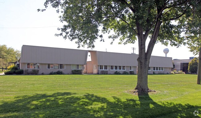
Property Detail
400 Jamison Rd
Buffalo-Cheektowaga, NY
GAS WELL FEE#1
144200-155-000-0001-005-111-A
Erie
Miningfacilityoilgasmineralpreciousmetals
New York
IND
5.111
B and X Area of moderate flood hazard, usually the area between the limits of the 100-year and 500-year floods.
73 AC
0
Outlying Erie County
2025
Buffalo/Niagara Falls
014102
NEARBY LISTINGS FOR SALE OR LEASE
-
-
View all Elma listings for sale on LoopNet.com
DEMOGRAPHICS near 400 Jamison Rd
1 mile
3 mile
5 mile
2025 Total Population
517
12,550
54,264
2030 Population
516
12,598
54,536
Pop Growth 2025-2030
(0.19%)
+ 0.38%
+ 0.50%
Average Age
46
46
45
2025 Total Households
213
5,220
22,070
HH Growth 2025-2030
(0.47%)
+ 0.34%
+ 0.46%
Median Household Inc
$112,500
$101,803
$106,524
Avg Household Size
2.40
2.30
2.40
2025 Avg HH Vehicles
2.00
2.00
2.00
Median Home Value
$341,000
$355,370
$340,157
Median Year Built
1960
1966
1973
Nearby Places
Map Layers
Map Styles
 Street
 Aerial
Layers
 Traffic
 Biking
Places
Listings with unknown addresses are not visible on the map
- Restaurants
- Banks
- Shops
- Fitness
- Groceries
PUBLIC TRANSPORTATION
AIRPORT
Buffalo Niagara International
Drive
Walk
Distance
Buffalo Niagara International
24 min
13.1 mi
Niagara Falls International
Drive
Walk
Distance
Niagara Falls International
47 min
31.8 mi
Freight Ports
Albany, NY Port
Drive
Walk
Distance
Albany, NY Port
343 min
286.2 mi
Nearby Properties
Address
Land Use
TOTAL SIZE
Lot Size
Zoning
Address
Land Use
TOTAL SIZE
Lot Size
Zoning
121,465 SF
4.20 AC
Address
Land Use
TOTAL SIZE
Lot Size
Zoning
1,409 SF
2.70 AC
Address
Land Use
TOTAL SIZE
Lot Size
Zoning
167,315 SF
5.32 AC
Address
Land Use
TOTAL SIZE
Lot Size
Zoning
129,572 SF
13.10 AC
Address
Land Use
TOTAL SIZE
Lot Size
Zoning
64,283 SF
18.67 AC
10
Address
Land Use
TOTAL SIZE
Lot Size
Zoning
178,744 SF
27.90 AC
Address
Land Use
TOTAL SIZE
Lot Size
Zoning
Address
Land Use
TOTAL SIZE
Lot Size
Zoning
124,495 SF
6.15 AC
Address
Land Use
TOTAL SIZE
Lot Size
Zoning
13,364 SF
407.01 AC
N000
Address
Land Use
TOTAL SIZE
Lot Size
Zoning
15,990 SF
2.09 AC
Address
Land Use
TOTAL SIZE
Lot Size
Zoning
4,511 SF
157.64 AC
R
Address
Land Use
TOTAL SIZE
Lot Size
Zoning
143,358 SF
15.62 AC
Address
Land Use
TOTAL SIZE
Lot Size
Zoning
55,413 SF
3.19 AC
Address
Land Use
TOTAL SIZE
Lot Size
Zoning
190,420 SF
117.90 AC
Address
Land Use
TOTAL SIZE
Lot Size
Zoning
13,874 SF
1.69 AC
Address
Land Use
TOTAL SIZE
Lot Size
Zoning
Address
Land Use
TOTAL SIZE
Lot Size
Zoning
5,246 SF
2.42 AC
Address
Land Use
TOTAL SIZE
Lot Size
Zoning
7,558 SF
4.50 AC
11
Address
Land Use
TOTAL SIZE
Lot Size
Zoning
117,130 SF
55.30 AC
Address
Land Use
TOTAL SIZE
Lot Size
Zoning
13,286 SF
1 AC
Address
Land Use
TOTAL SIZE
Lot Size
Zoning
Address
Land Use
TOTAL SIZE
Lot Size
Zoning
211,575 SF
39.30 AC
Address
Land Use
TOTAL SIZE
Lot Size
Zoning
Address
Land Use
TOTAL SIZE
Lot Size
Zoning
26,770 SF
1 AC
Address
Land Use
TOTAL SIZE
Lot Size
Zoning
12,473 SF
3.15 AC
Address
Land Use
TOTAL SIZE
Lot Size
Zoning
61,248 SF
1.10 AC
Address
Land Use
TOTAL SIZE
Lot Size
Zoning
Address
Land Use
TOTAL SIZE
Lot Size
Zoning
218,990 SF
69.57 AC
COMM
Address
Land Use
TOTAL SIZE
Lot Size
Zoning
Address
Land Use
TOTAL SIZE
Lot Size
Zoning
15,984 SF
1.20 AC
The World's #1 Commercial Real Estate Marketplace
Connect with us
© 2026 CoStar Group
The information above has been obtained from sources believed reliable. While we do not doubt its accuracy we have not verified it and make no guarantee, warranty or representation about it. It is your responsibility to independently confirm its accuracy and completeness. Any projections, opinions, assumptions, or estimates used are for example only and do not represent the current or future performance of the property. The value of this transaction to you depends on tax and other factors which should be evaluated by your tax, financial, and legal advisors. You and your advisors should conduct a careful, independent investigation of the property to determine to your satisfaction the suitability of the property for your needs.